This item has been sold, but you can get on the Waitlist to be notified if another example becomes available, or purchase a digital scan.
1901 Stanford Map of the United States w/ Railroads for British Investors
UnitedStatesRailroads-stanford-1901$2,500.00


Title
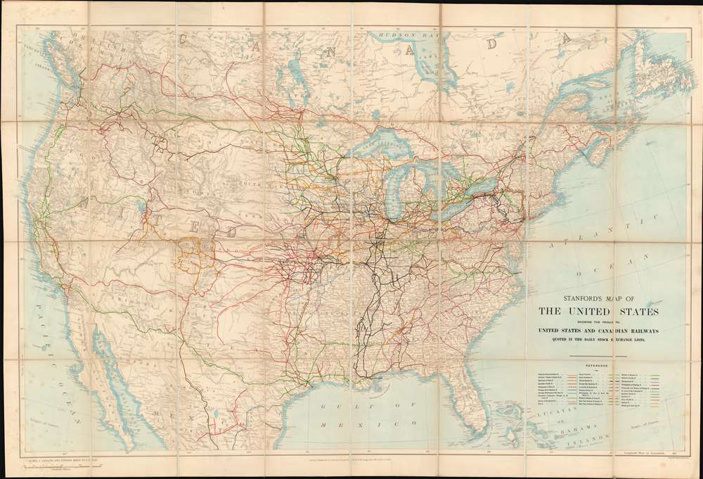
Stanford's Map of the United States showing the principal United States and Canadian Railways quoted in the Daily Stock Exchange Lists.
1901 (dated) 30.5 x 45.25 in (77.47 x 114.935 cm) 1 : 5274720
1901 (dated) 30.5 x 45.25 in (77.47 x 114.935 cm) 1 : 5274720
Description
Illustrating a little-known chapter of railroad history, this is an exceptional large-format 1901 Stanford map of the United States illustrating the growth and development of the American railroad system through the eyes of European investors. Embracing the whole of the United States, from Atlantic to Pacific, the nation is presented in a light sepia with multi-color overprinting illustrating the development of 31 different railroads. As the title suggests, the map is made for European investors, who financed more than 50% of American railroad growth. The leveraging of staggering amount of foreign investment, almost all in U.S. dollars, to construct the transcontinental railroad system, laid the foundations of American global economic dominance in the early 20th century.
On the American side, quoting Mira Wilkins in Foreign Investment in the U. S. Economy before 1914,
Foreign Investment in American Railroads
Foreign, particularly British and Dutch, investment fueled the development of the American trans-continental railroad system. The earliest British portfolio investments in U.S. railroads were private, through agents, but by 1838, U.S. Railroad companies were being listed on the London Stock Exchange. The appetite for American railroad securities became so voracious that the London Stock Exchange dedicated a special section to only these transactions. Likewise, by 1857, 57 percent of all securities quoted on the Amsterdam Stock and Securities Exchanges were committed to American Railroads.On the American side, quoting Mira Wilkins in Foreign Investment in the U. S. Economy before 1914,
In the late 19th century over 50% of the stock of such important American companies as the Pennsylvania Railroad (52%), the Illinois Central (65%), and the Louisville and Nashville (75%) was held abroad.Significantly, these securities were typically traded and held in U.S. Dollars. The investment required to construct multiple railroad networks across the vast expanse of the American west was so staggering that between 1880 and 1914, much of Europe's private wealth funneled to the United States and traded in American dollars. By 1913, these investments, and subsequent investments in other U.S. public and private sectors, catapulted the dollar to become the world's dominant currency and the U.S. to become the world's largest economy.
Chromolithography
Chromolithography is a color lithographic technique developed in the mid-19th century. The process involved using multiple lithographic stones, one for each color, to yield a rich composite effect. Oftentimes, the process would start with a black basecoat upon which subsequent colors were layered. Some chromolithographs used 30 or more separate lithographic stones to achieve the desired effect. Chromolithograph color could also be effectively blended for even more dramatic results. The process became extremely popular in the late 19th and early 20th centuries, when it emerged as the dominate method of color printing. The vivid color chromolithography produced made it exceptionally effective for advertising and propaganda imagery.Publication History and Census
This map was issued in 1901 by Stanford's Geographical Establishment. Today it is extremely rare, with only 2 other examples known, one at the British Library, and another at the University of Texas, Arlington.Cartographer
Edward Stanford (May 27, 1827 - November 3, 1904) was one of the most prolific map publishing firms of the late 19th century. The company began as a partnership in 1848 between the 21 year old Edward Stanford and the established map dealer Trelawney Saunders. By 1853 the partnership had dissolved and Edward Stanford took full control of the business. A subsequent series of expansions and exciting new map issues finally led to the production of Stanford's masterwork, "Stanford's Library Map of London". This map is still available and remains somewhat accurate. At the time of publishing it was hailed by the Royal Geographical Society as "the most perfect map of London that has ever been issued". In 1882 Edward Stanford Sr. passed the firm on to his son, Edward Stanford Jr. who continued in his father's proud tradition. Today the Stanford firm still publishes maps and remains one of the most important and prolific cartographic publishers in the world. More by this mapmaker...
Condition
Very good. Folds into original binder. Some light toning.
References
OCLC 557792039. British Library UIN BLL01004949557.