1735 Landteck / Homann Presentation of their Novel Universal Clock
UniversalClock-landteck-1735$600.00

Title
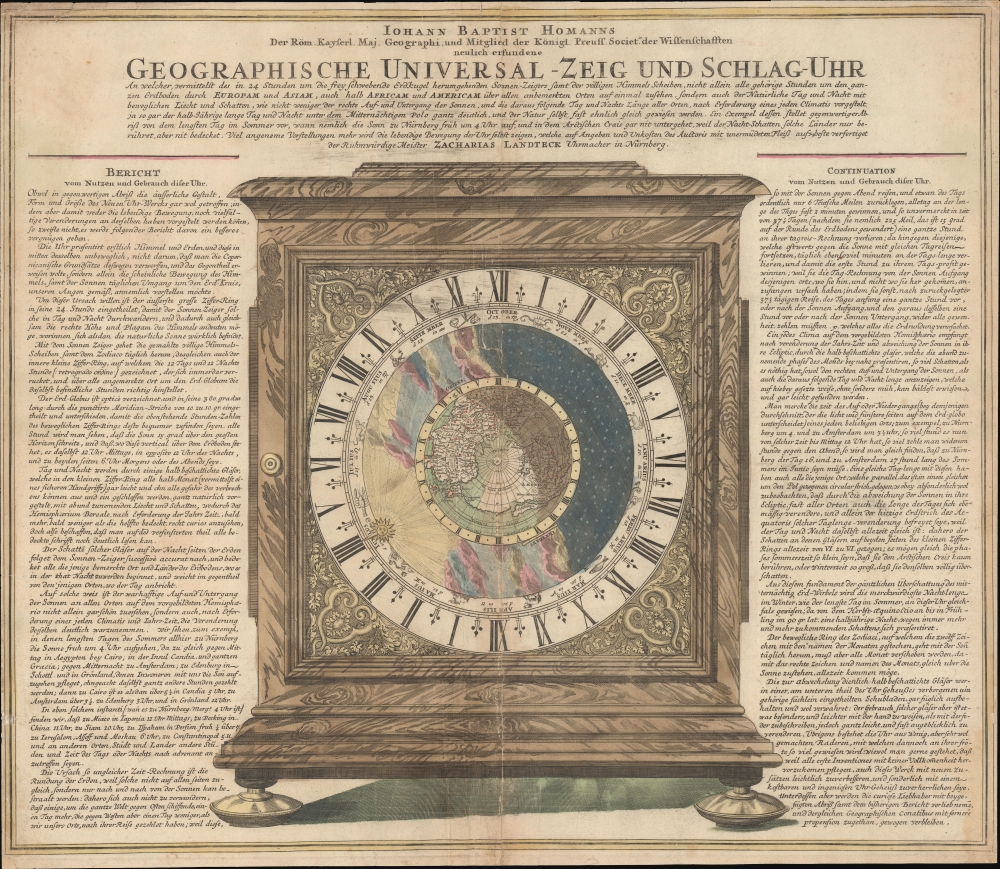
Geographische Universal - Zeig Und Schlag-Uhr.
1735 (undated) 19.75 x 22 in (50.165 x 55.88 cm)
1735 (undated) 19.75 x 22 in (50.165 x 55.88 cm)
Description
A remarkable c. 1735 Zacharias Landteck and J. B. Homman 'universal clock' with instructions on how to use time to determine longitude at sea - a perennial problem for mariners. The piece advocates for Homann's invention of the universal clock, known as Geographische Universal Zeig und SchlagUhr an (Universal Pointing and Chiming Clock), but this is unverified.
A Closer Look
This is meant to represent the Landteck clock, a physical clock constructed in 1705 by the Nuremburg clockmaker Zacharias Landteck (1670 - 1740), and, if this sheet is to be believed, invented by J. B. Homann himself in his role as an instrument maker. The primary image presents a clock handsomely housed in a wooden case. The central image is a northern polar projection (with insular California), surrounded by calendar and time dials which, on the actual clock, would have rotated. An additional ring, also rotating, is intended to distinguish night and day. In the example given here, the location of the day/night boundary is shown when the sun rises in Nuremberg on the summer solstice (on June 21 when the sun enters the sign of Cancer).The Universal Clock
There are at least two versions of this print, both of which are attributed to Homann, but one of which (this one) also attributed the invention of the clock to Homann, while the other attributes it to Landteck. It is unclear who invented the piece. The clock would have it possible to determine the local time along any meridian, as well as the positions and times of sunrise and sunset on any day of the year for any location in the Northern Hemisphere. This achievement was significant, for armed with this information, it was possible to calculate longitude at sea, a longstanding problem for mariners that would be officially resolved until Harrison's invention of the Marine Chronometer in, ironically, 1735.Geographische Universal Zeig und SchlagUhr an
It seems so! Wolfram Dolz, in his study of the piece, was able to identify an auction record of the clock selling in 1955, although there is no further knowledge of that example. However, in 2005 the Musée International d'Horlogerie in La Chaux-de-Fonds (Switzerland) managed to acquire an example for its collection - perhaps the 1955 example? In addition, in 1738 a copy of the clock was made for King Frederick August III of Poland, which survives.Publication History and Census
This image was published in at least 3 editions. One does not feature Homann's name and attributes the clock only to Lanteck. Another introduces Homan's name, but does not record his membership in the Königlich Preußische Sozietät der Wissenschaften (he was elected in 1715). A third, corresponding to this example, records the membership.CartographerS
Zacharias Landteck (1670 - 1740) was a clock- and watchmaker based in Nuremberg (Nürnberg), Germany. In 1705, he produced, either alone or in collaboration with J. B. Homann (1664 - 1724), a 'Universal Clock,' the Geographische Universal Zeig und SchlagUhr an, intended to assist in navigation by enabling mariners to determine the time at sea along any meridian. More by this mapmaker...
Johann Baptist Homann (March 20, 1664 - July 1, 1724) was the most prominent and prolific map publisher of the 18th century. Homann was born in Oberkammlach, a small town near Kammlach, Bavaria, Germany. As a young man, Homann studied in a Jesuit school and nursed ambitions of becoming a Dominican priest. Nonetheless, he converted to Protestantism in 1687, when he was 23. It is not clear where he mastered engraving, but we believe it may have been in Amsterdam. Homann's earliest work we have identified is about 1689, and already exhibits a high degree of mastery. Around 1691, Homann moved to Nuremberg and registered as a notary. By this time, he was already making maps, and very good ones at that. He produced a map of the environs of Nürnberg in 1691/92, which suggests he was already a master engraver. Around 1693, Homann briefly relocated to Vienna, where he lived and studied printing and copper plate engraving until 1695. Until 1702, he worked in Nuremberg in the map trade under Jacob von Sandrart (1630 - 1708) and then David Funck (1642 - 1709). Afterward, he returned to Nuremberg, where, in 1702, he founded the commercial publishing firm that would bear his name. In the next five years, Homann produced hundreds of maps and developed a distinctive style characterized by heavy, detailed engraving, elaborate allegorical cartouche work, and vivid hand color. Due to the lower cost of printing in Germany, the Homann firm could undercut the dominant French and Dutch publishing houses while matching their diversity and quality. Despite copious output, Homann did not release his first major atlas until the 33-map Neuer Atlas of 1707, followed by a 60-map edition of 1710. By 1715, Homann's rising star caught the attention of the Holy Roman Emperor Charles VI, who appointed him Imperial Cartographer. In the same year, he was also appointed a member of the Royal Academy of Sciences in Berlin. Homann's prestigious title came with several significant advantages, including access to the most up-to-date cartographic information as well as the 'Privilege'. The Privilege was a type of early copyright offered to very few by the Holy Roman Emperor. Though less sophisticated than modern copyright legislation, the Privilege offered limited protection for several years. Most all J. B. Homann maps printed between 1715 and 1730 bear the inscription 'Cum Priviligio' or some variation. Following Homann's death in 1724, the firm's map plates and management passed to his son, Johann Christoph Homann (1703 - 1730). J. C. Homann, perhaps realizing that he would not long survive his father, stipulated in his will that the company would be inherited by his two head managers, Johann Georg Ebersberger (1695 - 1760) and Johann Michael Franz (1700 - 1761), and that it would publish only under the name 'Homann Heirs'. This designation, in various forms (Homannsche Heirs, Heritiers de Homann, Lat Homannianos Herod, Homannschen Erben, etc.) appears on maps from about 1731 onwards. The firm continued to publish maps in ever-diminishing quantities until the death of its last owner, Christoph Franz Fembo (1781 - 1848). Learn More...
Condition
Average. Centerfold split repaired, no loss. Minor margin reinstatement to corners. Some spotting and toning. Some archival tissue verso reinforcement at margins and along fold lines.
References
Rumsey 9753.009. Wolfram Dolz, Johann Baptist Homann’s Geographic Universal Clock and the Small Globes of Sichelbarth and Doppelmayr, 'Globe Studies', no. 51/52, 2005, pp. 33 - 45.