This item has been sold, but you can get on the Waitlist to be notified if another example becomes available, or purchase a digital scan.
1848 Fremont Map of Upper California and Oregon
UpperCaliforniaOregon-fremont-1848$1,100.00

Title
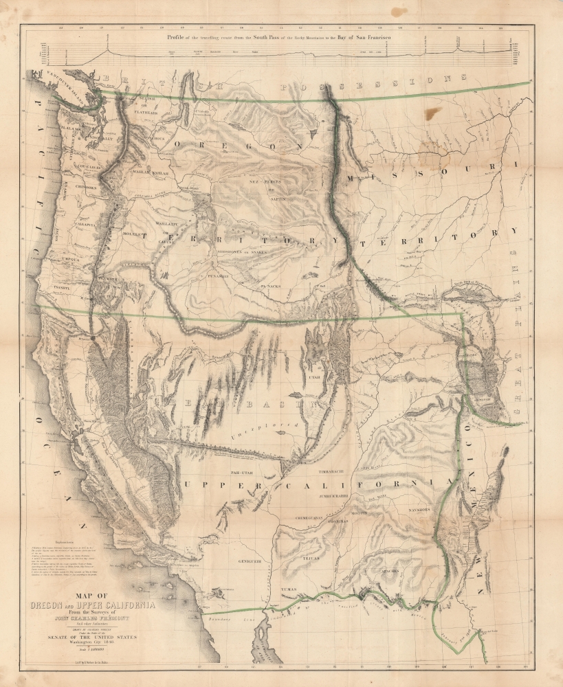
Map of Oregon and Upper California From the Surveys of John Charles Frémont.
1848 (dated) 35 x 28.5 in (88.9 x 72.39 cm) 1 : 3000000
1848 (dated) 35 x 28.5 in (88.9 x 72.39 cm) 1 : 3000000
Description
A landmark 1848 map of the American West by John C. Frémont and Carl Preuss. In the words of Carl Wheat,
More than any other persons, John Charles Fremont and Charles Preuss dominate the cartography of the American West during the three years before the Gold Rush and brought a human tide surging into that land which had so long lain beyond the ken of most Americans. (Wheat, C. I., Mapping of the Transmississippi West, 1540 – 1861, 523).
A Closer Look
Coverage embraces from the Rio Grande and modern-day Colorado, west to include most of what is today California, Arizona, New Mexico, Utah, Nevada, Washington, Oregon, Idaho Montana, and Wyoming. The map is described in detail by cartographic historian and dealer Paul Cohen in his study of western American maps,This important and beautifully drawn map became the model for many of the later gold region maps. The California portion is based on Fremont's map of 1845, but the legend 'El Dorado or Gold Rush Region' has been added along the 'Rio d. l. Plumas' (Feather River), and the 'R. d. l. Americanos' (American River), which is shown flowing out of 'Lake Bonpland' (Tahoe). The map covers the territory from the boundary of the 'British Possessions' on the north to the Mexican border on the south, and from the Pacific Ocean on the west to Fort Laramie and the 'Great Plains' on the east (Wheat). [B]y far the most accurate map of the Far West up to the time of its publication. The rapidly changing political character of the West is not neglected on the map. 1848 was a milestone year for establishing United States territories and boundaries, and the recognition of these most recent developments make the map an up-to-date document. 'Oregon Territory' established by Congress on August 114, 1848, is clearly delineated, as are the boundaries with Mexico laid out by the Treaty of Guadalupe Hidalgo. Missouri Territory is also indicated, as was, for the first time on a published map, the presence of the Mormons in the Great Basin.
Historical Context
This map emerged in the wake of the Mexican-American War (1846 - 1848) and the signing of the Treaty of Guadalupe Hidalgo, which ceded vast new territories to the United States including the present-day states California, Nevada, Utah, New Mexico, most of Arizona and Colorado, and parts of Oklahoma, Kansas, and Wyoming. The area was poorly understood. Fremont's reports and Preuss' maps were the best available geographic references to the region. Returning to Wheat,in the history of the American West, the year 1848 is signalized by three events above all others, the discovery of gold at Sutter's Mill… the formal close of the Mexican War… which brought the cession of California and New Mexico… and the creation of the Territory of Oregon… All three events figure in the characteristic maps produced during the year, and particularly the cartographic monument of 1848, the magnificent 'Map of Oregon and Upper California. (Wheat, C. I., Mapping of the Transmississippi West, 1540 – 1861, 49).
Publication History and Census
This map was published in 1847 to accompany Frémont's 1848 Geographical Memoire upon Upper California, a seminal work in its right. It was drawn by Charles Preuss, then engraved and printed by E. Weber of Baltimore. While the map comes to market from time to time, it remains an essential map for any collection focusing on the American Westward Expansion.CartographerS
John Charles Frémont (January 21, 1813 - July 13, 1890) was an American military officer, politician, and explorer. Fremont was born in Savannah, Georgia. A man of adventure, Frémont led several expeditions into the American West in the 1840s, earning the nickname 'The Pathfinder.' His explorations, documented in reports and maps, significantly contributed to the understanding of the western United States and were instrumental in guiding settlers to the region. Frémont's military career was marked by his role in the Bear Flag Revolt (June 1846), leading to the annexation of California as part of the United States. In politics, he was a prominent figure in the early Republican Party and was its first presidential candidate in 1856, though he was unsuccessful in his bid. His later life was marred by controversy and financial troubles, but his early contributions to the exploration and expansion of the American West cemented his place in U.S. history. He died in 1890 in New York City. More by this mapmaker...
Charles Preuss (1803 - September 2, 1854), or as he was born George Karl Ludwig Preuss, was a German-born lithographer and cartographer who produced several important maps of the American West in the middle part of the 19th Century. Preuss was born in Hohscheid, Germany, where grew up and studied the science of Geodesy. There he also studied lithography with its inventor, Aloys Snefleder. After mastering the art, he worked under the Prussian Government as a mapmaker and surveyor. Preuss immigrated to the United States with his wife and children in 1834. In the United States, he worked at a few minor drafting positions before taking work under Ferdinand Hassler and the U.S. Coast Survey. Hassler introduced Preuss to Captain John Charles Fremont, who was then planning his landmark surveying expedition to the American West. Impressed with Preuss' work, Fremont hired him as the expedition's cartographer. Preuss seems to have been singularly unimpressed with Fremont and the American West, complaining bitterly in his journals about both. He considered Fremont "childish" and the scenery "dull" and "lackluster." Nonetheless, he was convinced to participate in one expedition after another, and the maps he produced, both under Fremont and under Stansbury, were among the most important maps of the region ever drafted. These include, among many others, the first map of the Oregon Trail, the first accurate mapping of the Great Salt Lake, the naming of the Golden Gate, and the first identification of the California Gold region. Preuss's maps influenced North American cartography for the next two decades. Kemble Warren, who assembled Preuss' maps as well as the work of many others into his "General Map" of the American West, said of Preuss, "his skill in sketching topography in the field and in representing it on the map has never been surpassed in this country." Ultimately, despite his many successes, the admiration of his peers, and a life of adventure, Preuss seems to have suffered from chronic depression, apparently the result of sunstroke in California. In September of 1854, he hung himself from a tree limb in Washington, D.C. Learn More...
Source
Frémont, J. C., Geographical Memoir upon Upper California, in illustration of his Map of Oregon and California, (Washington: Wendell and Van Benthuysen) 1848.
Condition
Good. Some wear on old fold lines and verso stabilization at a few fold intersections. Minor fold split, about 3 inches, closed and reinforced on verso. A few minor discolorations.