
This item below is out of stock, but another example (left) is available. To view the available item, click "Details."
Details
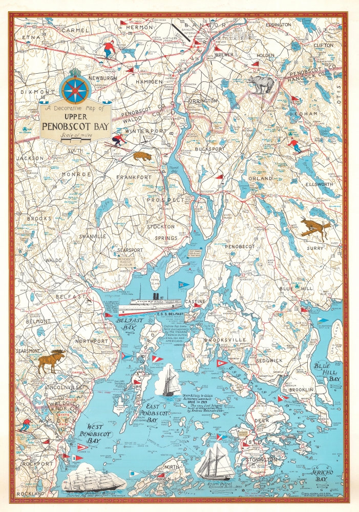
1972 Phillips Pictorial Map of Upper Penobscot Bay, Maine
$750.00
1972 Phillips Pictorial Map of Upper Penobscot Bay, Maine
UpperPenobscotBay-phillips-1972$200.00

Title
A Decorative Map of Upper Penobscot Bay.
1972 (dated) 26.75 x 18.5 in (67.945 x 46.99 cm) 1 : 126720
1972 (dated) 26.75 x 18.5 in (67.945 x 46.99 cm) 1 : 126720
Description
This is a charming 1972 Augustus D. Phillips pictorial map of the upper Penobscot Bay. Featuring illustrations of ships and local wildlife, Phillips's many iconic Maine maps combine practical information, history, humor, and beautiful detail, making them a favorite of 'in the know' collectors.
A Closer Look
Depicting from Bangor south to North Haven and Rockland, Phillips illustrates the lakes and topography, often identifying many geological features by name. Large red flags highlight golf courses. Wonderful illustrations of ships fill Belfast and Penobscot bays with short captions providing historical context. Triangular flags mark yacht clubs along the shores of both bays.Publication History and Census
This map was created by Augustus D. Phillips and published by A. D. Phillips and Son in 1972. A second edition was published by A. D. Phillips and Son in 1981. We note a single cataloged example of the present 1972 edition which is part of the collection at the University of Maine at Orono. The Osher Map Library at the University of Southern Maine has an example of the 1981 edition in their collection.Cartographer
Augustus Dewey Phillips (May 6, 1898 - December 14, 1975), a.k.a. 'Gus', was an American artist, cartographer, and publisher. Born on Mount Desert Island, Maine, as a boy Augustus and his brother Luther Savage Phillips (1891 - 1960) helped their dad in a variety of odd jobs, including maintaining a boat rental business and harvesting and selling ice. Augustus graduated from Hebron Academy and then attended the University of Maine for a short time. After leaving university, Phillips became a Maine Guide and worked as a carpenter and draftsman in the South Portland and Boothbay Harbor ship and boat yards. The brothers traveled together widely throughout Maine. Luther went on to start a popular map and postcard business out of Northeast Harbor, Maine. After Luther died in 1960, Augustus took over the map businesses. In a tragic turn of events, in 1973 an out of control bush fire destroyed the Phillips studio and much of the surviving stock, making all Phillips' maps issued prior to that date rare. His passion for landscapes helped Augustus create his own map style. Augustus expanded the business and continued making new maps until he died in 1975. Augustus' son, Donald Beekman Phillips (1935 - 2009) continued the business after his father's death. Augustus married Mary Fletcher on April 26, 1922, with whom he had four children. More by this mapmaker...
Condition
Good. Light creasing. Dampstain along top near border not visible on recto.
References
OCLC 182555211.