This item has been sold, but you can get on the Waitlist to be notified if another example becomes available, or purchase a digital scan.
1879 Viele First Map of the Upper West Side of Manhattan, New York City
UpperWestSide-viele-1879$2,500.00

Title
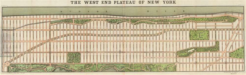
The West End Plateau of New York.
1879 (dated) 15.5 x 49.5 in (39.37 x 125.73 cm) 1 : 4500
1879 (dated) 15.5 x 49.5 in (39.37 x 125.73 cm) 1 : 4500
Description
This is the first separately published map of the Upper West Side of Manhattan (New York City) and arguably the first printed map of the Upper West Side. Published in 1879 by Herman Knickerbocker Vielé, son of the prominent New York mapmaker and politician Egbert Ludovicus Vielé, this map was issued to promote real estate investment in the high ground of the Upper West Side. The map covers Manhattan from roughly Columbus Circle (58th Street) to 130th Street, between the Hudson River and Central Park. It includes all of Riverside Park, the Western side of Central Park, Morningside Park, the future site of Columbia University (Bloomingdale Lunatic Asylum), and Manhattan Square (American Museum of Natural History). Along 9th Avenue (Columbus Ave), the map illustrates the West Side and Yonkers Patent Railway Company, service along which opened in June of 1879 as far as 104th Street, and by December of the same year, to 155th Street.
The Vielé family, seemingly through Herman, was heavily invested in the Upper West Side and correctly surmised that leveled high ground would soon become one of Manhattan's most desirable residential areas. From the beginning Vielé promoted with Upper West Side as a haven for the merchant aristocracy. In the 25-page promotional pamphlet accompanying this map, the elder Vielé, Egbert, describes the 'West End Plateau,'
The OCLC identifies institutional holdings at the New York Public Library, the New York Historical Society, Columbia University, Stanford University (Rumsey), and at the New York State Library. All of these holdings, with the exception of Stanford, can be traded to the map's original publication. We are aware of only 6 examples that have changed hands privately between 1910 and present.
An Exploding American Metropolis
When this map was issued, New York was a fast-growing city, but the Upper West Side, the streets for which were planned as early as 1811, was largely uninhabited. Throughout the 1860s and 1870s, Central Park was under construction and the city was involved with the complex project of acquiring the lands north of 14th street from the various estates and heirs, many dating to the Dutch period, who claimed ownership. The Commissioners Law granted the city right to the land under eminent domain, but owners and heirs were often recalcitrant and unwilling to accept the compensation the city was required to provide for land seizures.As Remote as the Dakota Territory
The Upper West Side or West End Plateau, as the title of this map suggests, was initially a hilly high ground called by some the 'spine of Manhattan.' Initially the rocky terrain focused urban development on the more level East Side of the city, where Park Avenue, planned by Vaux and Olmsted, became a nexus of elite social life. While the Upper East side of Manhattan was being developed, the city leveraged massive resources to uniformly grade the hills Upper West Side. This work was largely completed by the late 1870s, and real estate development began in earnest in the 1880s. The first major luxury apartment building on the Upper West Side, the Dakota, began being constructed in 1880s and opened its doors in 1884. It was called the Dakota because it was considered as distant from New York society as the 'Dakota Territory.' Photos from this period show the Dakota as a lone monolith lording over Central Park.Upper West Side Real Estate Development
Nonetheless, city planners correctly anticipated explosive growth in upper Manhattan and the Vielé family was uniquely positioned to profit on the development. Herman Vielé father, Egbert, is best known today as the author of the Vielé Map, a massive map of Manhattan illustrating the over and underground waterways throughout the city. Egbert Vielé, initially a sanitary commissioner, was responsible for the construction of Central Park and, by the 1870s, had become a prominent and wealthy politician with far reaching interests that included not only Manhattan real estate, but mining companies in Colorado and more.The Vielé family, seemingly through Herman, was heavily invested in the Upper West Side and correctly surmised that leveled high ground would soon become one of Manhattan's most desirable residential areas. From the beginning Vielé promoted with Upper West Side as a haven for the merchant aristocracy. In the 25-page promotional pamphlet accompanying this map, the elder Vielé, Egbert, describes the 'West End Plateau,'
The conclusion is inevitable, therefore, that the section of the city that has been held in reserve until the time when the progress of wealth and refinement shall have attained that period of its development when our citizens can appreciate and are ready to take advantage of the situation, is the section that is to be the most favored and the most sought after. At an expense unparalleled except in the lavish period if imperial opulence the great west end plateau … has been laid out and ornamented with a series of magnificent avenues not excelled by any other in the world. Moreover, this entire region combines in its general aspect all that is magnificent in the leading capitals of Europe. In our Central Park we have the fine Prater of Vienna, in our grand boulevard the rival of the finest avenues in the gay capital of France, in our Riverside Avenue, the equivalent of the Chiaja of Napes and the Corso of Rome, while the beautiful 'Unter den Linen' of Berlin, and the finest portions of the West End of London are reproduced gain and again…Vielé further anticipated that the West End Plateau (Upper West Side) would become home to 'a higher order of domestic architecture that it has been the good fortune of New York heretofore to possess.'
Publication History and Census
This map was printed by Johnson and Pratt of New York for Herman K. Vielé. There appears to be only one edition and all examples are scarce. The map is accompanied by a 25-page booklet penned by Egbert L. Vielé describing the virtues of the West End Plateau in exceptionally bounteous terms.The OCLC identifies institutional holdings at the New York Public Library, the New York Historical Society, Columbia University, Stanford University (Rumsey), and at the New York State Library. All of these holdings, with the exception of Stanford, can be traded to the map's original publication. We are aware of only 6 examples that have changed hands privately between 1910 and present.
CartographerS
Herman Knickerbocker Vielé (January 31, 1856 - December 14, 1908) was an American surveyor, civil engineer, artist, novelist, playwright, and poet active in the late 19th and early 20th centuries. He was the son of the important 19th century New York civil engineer, mapmaker, and politician Egbert Ludovicus Vielé. Herman Vielé was initially trained to follow in his father's footsteps as a surveyor and civil engineer. His early employment history is vague, but he did work in Washington D.C. surveying subdivisions for real-estate developers. He actively lobbied for street extension work and the development of the Upper West Side in the late 1870s. In 1879 he testified to block the construction of the Brooklyn Bridge, which he rightly claimed could not be completed on the projected budget. In the 1890s he completed various surveys in Boston regarding the extension of Massachusetts Avenue. Despite his very active career as a Civil Engineer, Herman Vielé is best known as a writer and artist, authoring several books between 1901 and 1908. His most prominent work is The Last of the Knickerbockers, a comedic look at the Dutch heritage of New York. His final work, On the Lightship was published posthumously in 1909. He was marred in 1887 to Mary Warton of Philadelphia. More by this mapmaker...
Egbert Ludovicus Vielé (June 17, 1825 - April 22, 1902) was an American civil engineer, cartographer, businessman, and politician active in New York City during the second half of the 19th century. Born in Saratoga County, Vielé attended the United States Military Academy at West Point. Graduating in 1847, he was commissioned as a brevet second lieutenant in the 2nd United States Infantry. He served in the Mexican-American War before resigning form military duty to pursue a career as a Civil Engineer in New York City. When the call came to plan New York City's Central Park in 1856, Vielé was established as Engineer-in-Chief of the project, and it was he who set down the guidelines by which Vaux and Olmstead ultimately planned the park. He held a similar position as engineer of Prospect Park, Brooklyn from 1860. It was most likely during his tenure with the park commissions that Vielé developed his theories connecting compromised natural drainage with sanitation and infectious disease. Vielé's great cartographic masterpiece, the Topographical Map of the City of New-York, euphemistically known as the 'Vielé Map' or 'Waterways Map' evolved out of the notion that epidemic level disease evolved from excess moisture in the soil. He contended that, as New York City expanded northwards, paving over stream beds and leveling out natural drainage channels, the underground waterways would stagnate and lead to plague or worse. Though intended for the purpose of urban planning, the Vielé Map's (as it came to be known) greatest legacy is as a construction tool. To this day, contractors, architects, and engineers consult the Vielé map to determine if unseen subterranean waterways need to be taken into account when preparing building foundations. He was elected as a Democratic representative to the Forty-ninth Congress (March 4, 1885 – March 3, 1887) and ran unsuccessfully for re-election in 1886. He was heavily involved in New York real-estate interests, but also owned shares of mining and railroad companies as far off as Colorado. Vielé died in April of 1902 and was buried in an elaborate Egyptian Revival tomb at West Point. Legend tells that Vielé, paranoid that he would be buried alive, an unfortunate but surprisingly common problem in the 19th century, installed a buzzer inside his coffin that would allow him to ring the school's commanding officer should the need arise. Apparently, it did not. Learn More...
Condition
Very good. Laid down on archival tissue. Some minor spits repaired. Minor infill. Datached but accompanied by original boards.
References
Rumsey 2556.003. OCLC 58758870. Chace Viele, p.40. Stokes, I. N. P., The Iconography of Manhattan Island, 1498-1909, v5, p1968-70. Haskell, D., Manhattan Maps A Co-operative List, 1334. New York Public Library, Map Div. 15-678.