This item has been sold, but you can get on the Waitlist to be notified if another example becomes available, or purchase a digital scan.
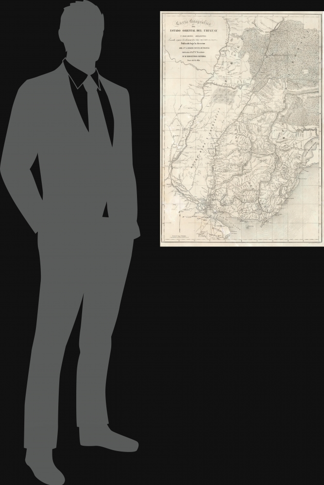
1841 Aimé Roger Map of Uruguay: First Detailed Map of the Republic
Uruguay-roger-1841$4,250.00


Title
Carta Geografica del Estado Oriental del Uruguay y Posesiones Adyacentes Trazada segun los documentes mas recentes y exactes.
1841 (dated) 31.75 x 22.25 in (80.645 x 56.515 cm) 1 : 1764000
1841 (dated) 31.75 x 22.25 in (80.645 x 56.515 cm) 1 : 1764000
Description
This is an extremely rare, separately issued lithograph 1841 map of the Republic of Uruguay during the early years of Uruguay's Independence and civil war. It was published in Paris on behalf of the French diplomat, Aimé Roger, and can be considered the first, detailed map of the independent Republic.
Roger's map was not an official map of the new nation - this would not be produced until 1884. It is likely that the changeability of Uruguayan politics interfered with the acceptance of this map over the long term. The 1842 Battle of Arroyo Grande saw Rivera defeated and left the whole of the country outside of Montevideo in Blanco hands. Only after the protracted Siege of Montevideo and the intervention of Brazil did power return to the Colorados. By this time, both the English and the French extricated themselves from La Plata's incessant wars, and Roger himself was re-posted to New Orleans. The violent fluctuations in Uruguayan leadership, the shifts of French policy, and the changing fortunes of Roger's career conspired to relegate the present map to undeserved obscurity.
Historical Context
As French consul, Roger is unlikely to have been the cartographer, but since Uruguay and La Plata were an active theatre of war, it is likely the sources were military - possibly even Uruguayan, given the extreme detail on the interior. The map is dedicated to Uruguay's President José Fructuoso Rivera y Toscana, (1784 - 1854) founder of the Colorado (Red) Party. While Uruguay itself was not a major focus of French policy, France had been taking sides in South America in general against the protectionist Argentine Confederation, allying with Peru and Bolivia who supported free trade with Europe. In order to bring pressure against Argentina, France supported President Rivera's Colorados, who was in armed conflict with the Buenos Aires-supported Blancos under General Manuel Oribe. The production and dedication of this map represented both a material and symbolic aid to Rivera.A Closer Look
The map's broad detail shows influence from the surveys of Felix de Azara, particularly with respect to the area between the Parana and Uruguay rivers, and the Laguna Ybera. For the interior of Uruguay, however, we see no resemblance with Azara's late 18th - early 19th century work. The general pattern of this map's rivers and mountains draws heavily on the 1827 Cary map, but Roger's map is significantly updated - particularly with respect to roads, both within Uruguay and across its frontiers. It includes roads across the Rio de la Plata near Buenos Aires, and across the border into Brazil, between the Rio Yaguaron and the Rio Bacacay. None of the roads and few of the towns of the interior on the present work appear on the Cary, which prior to this was the most detailed map available of the 'Provincia Oriental'. The patterns of the lagoons along the coast northeast of Maldonado are also very different from the Cary (who copied Azara's treatment of the coast).Roger's map was not an official map of the new nation - this would not be produced until 1884. It is likely that the changeability of Uruguayan politics interfered with the acceptance of this map over the long term. The 1842 Battle of Arroyo Grande saw Rivera defeated and left the whole of the country outside of Montevideo in Blanco hands. Only after the protracted Siege of Montevideo and the intervention of Brazil did power return to the Colorados. By this time, both the English and the French extricated themselves from La Plata's incessant wars, and Roger himself was re-posted to New Orleans. The violent fluctuations in Uruguayan leadership, the shifts of French policy, and the changing fortunes of Roger's career conspired to relegate the present map to undeserved obscurity.
Publication History and Census
This map was printed in Paris in 1841, apparently simultaneously by two separate printing houses: this one by Napoléon Chaix, and the other by Eugène Kaeppelin. Both are extremely rare. We see one example of this Chaix edition held by the Bibliotheque National de France; the Kaeppelin has four entries in OCLC. No market history.CartographerS
Aimé Roger (fl. 1836-1868) was a French diplomat active in South America during the post-independence struggle for dominance in the La Plata region. Virtually nothing is known about him: there is no convincing record of his birth or death, and no record at all of his education or training. He first appears in the historical record as an attaché in the French consulate in Buenos Aires. In 1736 he was to be reassigned to a new consulate in Albania, but the political ferment in La Plata resulted in France's decision to keep him in place as vice-consul. He produced a report on the Paraguayan dictator José Gaspar Rodríguez de Francia. Later that year, the death of his superior led to Roger temporarily being made head of the French legation. France's policies were at the time expansionist, and in the South American theater this led France to support regimes friendly to foreign trade. In 1837, France saw the coalition of Peru and Bolivia as favorable to French interests; the Argentine Confederation were protectionist, and aligned against Peru and Bolivia. Roger was sent in 1838 to deliver an ultimatum to Argentina in advance of a French blockade of the Rio de la Plata, insisting on exemption of French subjects from military service and ensure 'most favored nation' treatment for France. Roger also maneuvered to develop relations with Uruguay's Colorado party, whose domestic foes, the Blancos, were supported by Argentina. The notion was to support the blockade with an Uruguayan alliance, relieving France of the necessity of landing troops (a move that would have run afoul of relations with the British). Neither the blockade nor Roger's other truculent moves were successful, and ultimately the French would withdraw from the conflict. Roger was subsequently appointed consul in New Orleans, where he appears to have caused little more trouble than marrying an American, with whom he would have a child. He is understood to have remained in New Orleans twenty years before returning to France. More by this mapmaker...
John Cary (1754 - 1835) was a London based cartographer active in the early part of the 19th century. Ronald Vere Tooley, the prominent English map historian, writes of Cary, "As an engraver he was elegant and exact with fine clear lettering and great delicacy of touch." Cary began his work as an engraver, cartographer, and globe maker in 1776 with his New and Correct English Atlas. This important atlas represented a new phase in cartography where accuracy and detail rose in prominence over the decorative embellishments of the 18th century. This change was indicative of the times when travel and commerce were expanding globally as never before. Cary's mastery of both engraving and cartography resulted in a series of seminal works that redefined mapmaking in the early 19th century. His stupendous Cary's New Universal Atlas, published in 1808, set the standard for all cartographers who followed. Cary reissued this seminal atlas in 1811, 1819, 1824, 1828, 1833, 1836 and 1844. Cary also did considerable work on the English Ordinance Survey prior to 1805. His cartographic work particularly inspired the Edinburgh school of cartography as represented by John Pinkerton and John Thomson. In America, Cary's work was used as the basis for Tanner's important New American Atlas. Cary's last published atlas appeared posthumously in 1844, however, by 1850 Cary's work was being carried on by his sons and other well-known cartographers including James Wyld, John Tallis & Company, and Crutchley. Learn More...
Azara, Félix de (May 18, 1742 - October 20, 1821) was a Spanish military officer, naturalist, and engineer. He joined the Army, and received training as an engineer in a Spanish military academy. His thirteen year career in the Army would see him promoted to Brigadier General. He spent twenty years in the Rio de la Plata region of South America as a delegate under the treaty of San Ildefonso, during which period he undertook to create an accurate map of the region. On the surveys, he also recorded the fauna the region, in particular cataloguing nearly four hundred species of bird. On his return to Europe in 1801 he wrote and published in Paris his Voyage dans l'Amerique meridionale depuis 1781 jusqu'en 1801 (1809) which contained his observations on the region's geography, natural features, and indigenous groups. His work was praised for thoroughness and accuracy, and was well regarded by Darwin. He died of pneumonia on October 20, 1821. Learn More...
Condition
Fair. Marginal mend to top; mended tear at bottom; area of reinstatement with some loss to lower left. Mounted on linen and fully stabilized, else very good.
References
OCLC 494196029.