This item has been sold, but you can get on the Waitlist to be notified if another example becomes available, or purchase a digital scan.
1827 Map of Uruguay, the Banda Oriental, and southern Brazil
Uruguay-vandermaelen-1827$275.00

Title
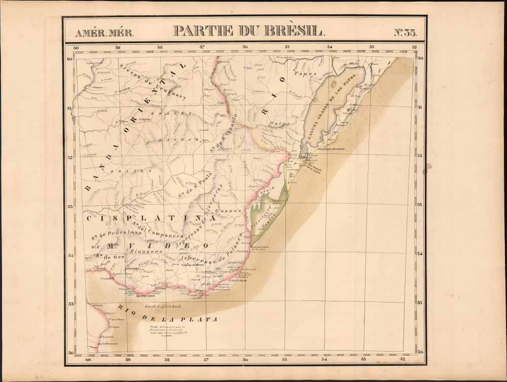
Partie du Brèsil. Amer. Mér. no. 35.
1827 (undated) 19 x 19.5 in (48.26 x 49.53 cm) 1 : 1641836
1827 (undated) 19 x 19.5 in (48.26 x 49.53 cm) 1 : 1641836
Description
This is the rare 1827 Vandermaelen map of the Cisplatine region: the Banda Oriental and southern Brazil, which would become Uruguay in South America.
A Closer Look
The map covers from the mouth of the Rio de la Plata to the Laguna de los Patos. This embraces all of modern-day Uruguay. Although the map was printed in 1827, it is likely that the surveys that informed it predated the Brazilian invasion of the Banda Oriental in 1816. Here, Uruguay is 'Cisplatina ou Mte. Video' reflecting the pre-invasion terminology. Likewise, there is no sign here of the 1825 unification of the Thirty-Three Orientals with the United Provinces and independence from Brazil, and the subsequent Brazilian declaration of war. This was among the largest-scale maps of this region produced to date. By applying a uniform scale to every map, Vandermaelen afforded sharper detail to many remote areas of the world previously not so well depicted. This is also the first map of the region executed in lithograph.Publication History and Census
This map appeared in the fifth part, 'Cinquième partie, Amér. mérid.' of Vandermaelen's Atlas universel de géographie physique, politique, statistique et minéralogique. The atlas was produced in one edition in 1827. Only 810 complete sets were sold. The full set of six volumes appears in eleven institutional collections in OCLC. The 5th volume alone is listed in 11. This map is listed as a separate map only at the Clements Library.Cartographer
Philippe Marie Guillaume Vandermaelen (December 23, 1795 - May 29, 1869) was a Flemish cartographer active in Brussels during the first part of the 19th century. Vandermaelen is created with "one of the most remarkable developments of private enterprise in cartography," namely his remarkable six volume Atlas Universel de Geographie. Vandermaelen was born in Brussels in 1795 and trained as a globe maker. It was no doubt his training as a globe maker that led him see the need for an atlas rendered on a universal scale in order that all bodies could be understood in relation to one another. In addition to his great work Vandermaelen also produced a number of globes, lesser maps, a highly detailed 250 sheet map of Belgium, and several regional atlases. More by this mapmaker...
Source
Vandeermaelen, P., Atlas universel de geographie physique, politique, statistique et mineralogique, (Bruxelles: Vandermaelen) 1827.
Atlas Universel de Geographie. This great work, featuring some 378 unique maps and compiled over three years, was the first lithograph atlas, and the first to render the world on the same projection and at a uniform scale. It was no doubt Vandermaelen’s training a globe maker that led him see the need for an atlas rendered uniformly so that all bodies could be understood in relation to one another. As a result, many newly emerging areas received more attention than prior efforts. Maps of the American West, in particular, benefited: ‘no mapmaker had previously attempted to use such a large scale for any western American area.’ (Wheat). Central and South Asia also appear in sharper focus. Despite Vandermaelen’s reliance upon existing sources, his maps very frequently provided the clearest depictions available of many poorly-understood parts of the world. The atlas was an expensive production, costing $800 in 1827. Subscription lists indicate that only 810 full sets of the atlas were sold. It was printed on high-quality paper with superior hand coloring and was engraved in a clear, legible style. Conjoined, the maps of Vendermaelen's atlas would create a massive globe some 7.75 meters in diameter, a feat which was accomplished at the Etablissement Geographique de Brussels.
Condition
Very good. Errant spot of original color at right border, else excellent.
References
Rumsey 2212.319. OCLC 889736441.