1834 Depot de la Marine Nautical Chart or Map of the United States East Coast
USEastCoast-depotmarine-1834$950.00


Title
Carte de la Côte Orientale de l'Amérique Septentrionale Partie Comprise Entre New York et la Rivière Saint Jean.
1834 (dated) 24.5 x 35 in (62.23 x 88.9 cm) 1 : 2000000
1834 (dated) 24.5 x 35 in (62.23 x 88.9 cm) 1 : 2000000
Description
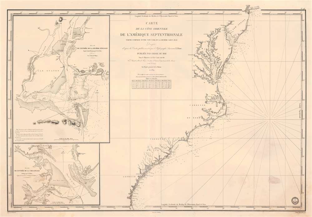
This is an 1834 French Dépôt-général de la Marine nautical chart or maritime map of the east coast of the United States. The map appeared at the height of the U.S.-French textile trade, which it was likely published to support. Southern ports in Virginia, Carolina, and Georgia provided the bulk of cotton for the French textile industry - a fact that would become a major point of contention during the Civil War (1861 - 1865), leading to the Cotton Famine (1863 - 1863). Depicting from New York City south to the mouth of the St. Johns River in Florida, coastal detail abounds. Depth soundings are indicated along the entire coastline, along with inlets, capes, banks, and coastal islands. The Delaware River is charted to Philadelphia. The Chesapeake Bay is detailed as far as Charlestown and Elkstown. The Potomac River (labeled here as Potomack) is illustrated to Washington, D.C., and the Rappahannock River (labeled here as Rappanahock) runs to Fredericksburg. Both Richmond and Petersburg are labeled along the James River, as is Norfolk. Albemarle and Pamlico Sounds are detailed in North Carolina, and Cape Hatteras, Cape Lookout, and Cape Fear are labeled. Both Charleston and Savannah are identified.
Insets
Two inset maps adorn the left side of the sheet. The top map details New York Bay and New York Harbor. Depth soundings are provided and navigational hazards, such as banks and reefs, are illustrated. Governor's Island and Ellis Island are both labeled, along with Red Hook, Brooklyn, Williamsburg, Bushwick, and Gravesend. The lower inset applies the same level of detail to the Chesapeake Bay. Shoals, banks, grounds, channels, and other navigational aids are all illustrated and labeled. Numerous depth soundings are indicated, particularly along suggested navigation channels. Hampton Roads, Newport News, and both the York and James Rivers are illustrated and labeled.Publication History and Census
This map was drawn by Jacques-Marie Hacq and engraved by Chassant from maps published by Edmund Blunt and published by the Dépôt-général de la Marine in 1834. We note two examples cataloged in OCLC: Université Laval in Québec and the Muséum national d'histoire naturelle in Paris.CartographerS
Dépôt des Cartes et Plans de la Marine (fl. 1720 - present), often called the Dépôt de Marine, was a French hydrographic mapping organization founded in 1720 under Charles-Hercule of Albert de Luynes (1674 - 1734). Much like the U.S. Coast Survey, the British Admiralty, and the Spanish Deposito Hydrografico, the Dépôt was initiated as a storehouse and distribution center of existing nautical and marine charts. Eventually the Dépôt initiated its own mapping activities in an attempt to improve and expand upon existing material. Some of the more prominent cartographers and hydrographers associated with the of Dépôt des Cartes were, Philippe Buache, Jacques-Nicholas Bellin, Giovanni Rizzi-Zannoni, Rigobert Bonne, and Jean Nicolas Buache. More by this mapmaker...
Jacques-Marie Hacq (September 22, 1785 – 18??) was a French letter and line engraver, and historian, active in Paris during the middle part of the 19th century. Hacq was born in Paris and trained under J. P. Besançon, who he succeeded at the Dépôt de la Guerre in 1830. He engraved for the Dépôt de la Guerre as early as 1830 and for the Dépôt des Cartes et Plans de la Marine from, at least, 1840 to 1852. In addition to his work for the French Government, he also completed maps and engravings for Lesage, Lapie, Dufour, Duperrez, Gouvion St. Cyr, and Dumont d'Urville. His historical works include a history of the Napoleonic Wars and a history of Paris under the reign of Louis XIII. During most of his career in Paris he lived at 58 Rue de la Harpe. Learn More...
Chassant (fl. c. 1830 - 1860) was a French line and chart engraver active in Paris in the middle part of the 19th century. Chassant was active with the French Dépôt de Marine from the 1830s into the 1860s. He was a master engraver and, some have argued, his dramatic hachuring work to illustrate topography suggests he may have been wasted on nautical charts. Most of his engraving was completed in partnerships with Jacques-Marie Hacq (September 22, 1785 – 18??). Chassant did not sign any of his engravings with a first name or other identifier, so it is difficult to track him down. He may be Alphonse Antoine Louis Chassant (August 1, 1808 - September 7, 1907), who in later life was an art historian and librarian of the city of Évreux. He wrote several books, including works on engraving. We cannot alas verify the connection and it may be pure guesswork. Learn More...
Edmund March Blunt (June 20, 1770 - 1862) was an American navigator, bookseller, chartmaker, and cartographer based in Newburyport, Massachusetts. Blunt was born in Portsmouth, New Hampshire in 1770. In 1796, along with the nominal assistance of prominent navigator Captain Lawrence Furlong, Blunt published The American Coast Pilot, one of the most important published works on American navigation. Although much of the work was plagiarized from British publications, the Coast Pilot was an immediate popular success. In response to the popularity of his work, Blunt published 21 subsequent editions, each with important updates and revisions. The first edition to contain map plates was printed in 1804. Following a fire that destroyed his offices at The Sign of the Bible in 1811, Blunt moved his business to New York and opened a new shop, The Sign of the Quadrant. His sons Edmund Jr. (1799 - 1866) and George William (1802 - 1878), joined the firm in 1824 and eventually took over the family business, renaming the firm 'E. and G. W. Blunt'. They both produced their own nautical books, charts, and instruments, as well as republished their father’s work. In 1830, Edmund accepted a position under Ferdinand Hassler at the United States Office of the Coast Survey. Much of Blunt's original work eventually found its way into U.S. Coast Survey Publications. George closed the firm in 1872 and sold the plates and chart copyrights to the U.S. Coast Survey and the U.S. Navy Hydrographic Office. Due to the quality and detail of Blunt's work, revised editions of his most important charts were republished well into the 1880s. Learn More...
Condition
Very good. Toning along original centerfold. Light soiling.
References
OCLC 1131387017.