
This item below is out of stock, but another example (left) is available. To view the available item, click "Details."
Details
1799 Vancouver Map of Vancouver Island, Washington, and Puget Sound
$3,500.00
1799 Vancouver Map of Vancouver Island, Washington, and Puget Sound
VancouverWashington-vancouver-1799-3$2,500.00

Title
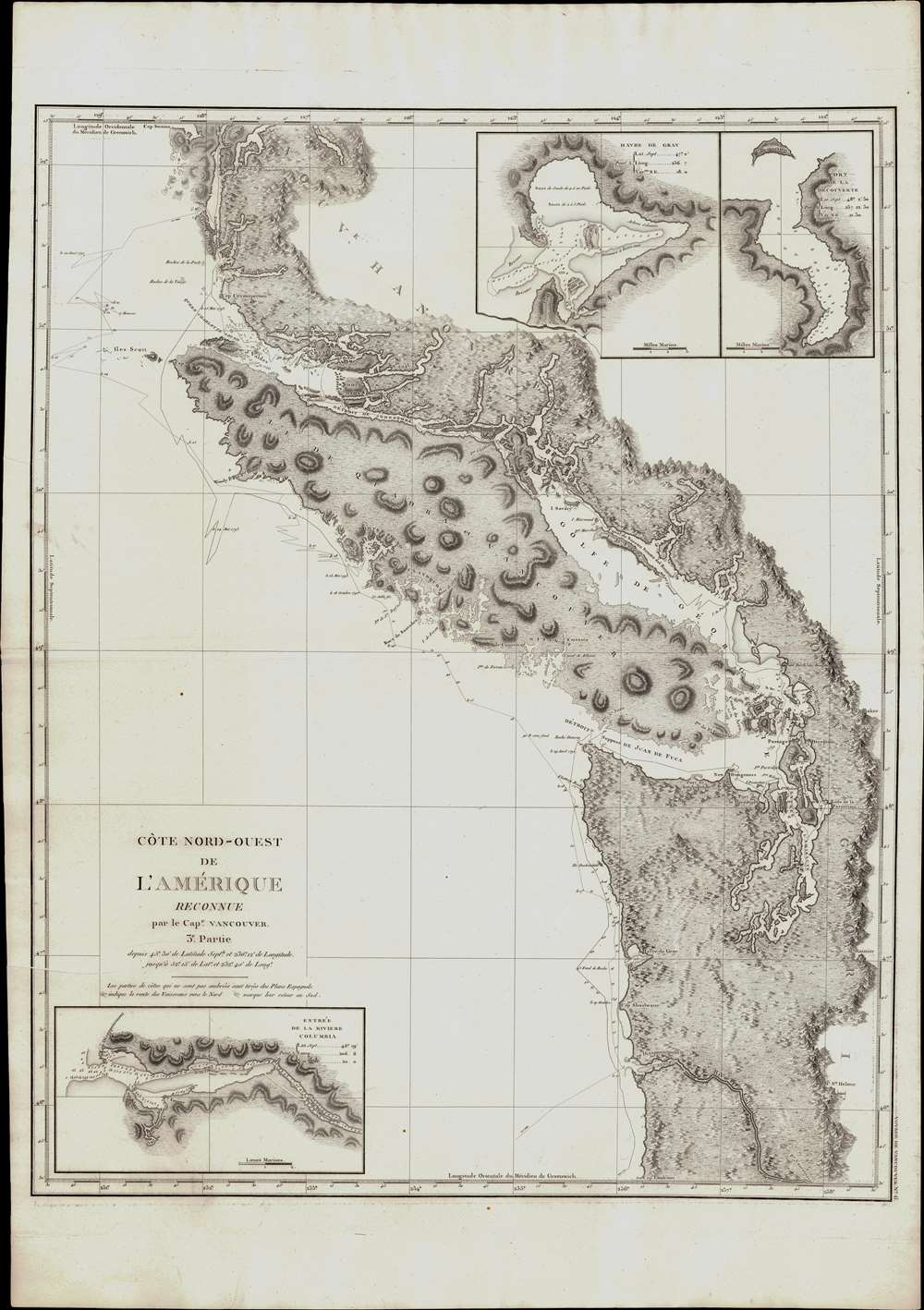
Cote Nord-Ouest de L'Amerique Reconnue par le Cape. Vanouver. 3e. Partie.
1799 (undated) 30 x 24 in (76.2 x 60.96 cm) 1 : 1058201
1799 (undated) 30 x 24 in (76.2 x 60.96 cm) 1 : 1058201
Description
This is the 1799 French edition of George Vancouver's 1799 nautical map of the region around Vancouver Island, the Strait of Juan de Fuca, the mouth of the Columbia River, and Queen Charlotte Sound, extending from Cape Lookout (in modern-day Oregon) to Cape Swaine (Alaska). It is considered to be the great navigator George Vancouver's most important and influential map, among those he produced in his foundational reconnaissance of the northwest coast of America (1791 - 1795).
In 1795, Vancouver returned to a Europe enmeshed in the French Revolutionary Wars (1792 - 1802). With the looming threat of Napoleon, Britain had little interest in science and discovery. Thus, despite his achievements, the great explorer was sidelined and besieged by personal and political enemies made during the voyage, including the expedition's naturalist Archibald Menzies (1754 - 1842) and the wastrel sailor Baron Thomas Pitt (1775 - 1804), who attempted to beat Vancouver down on the streets of London. By this time, the navigator's heath had also deteriorated and he died in 1798 - of unknown causes.
Notable Firsts
This beautifully engraved chart features a number of notable firsts, including the first charting of the Puget Sound, the first depiction of Vancouver as an island, and the first charting of the Johnston Strait. The chart also includes crucial coastal details, with Mount Rainier, Mt. St. Helene (Mt. St. Helens), and Mount Baker all shown. Insets in the upper right detail Cape Gray (Havre de Gray) and Port Discovery (Port de la Decouverte). Another inset in the lower-left focuses on the mouth of the Columbia River, soon to become a major artery for the fur trade.Vancouver Expedition (1791 - 1795)
The Vancouver Expedition was an epic four-and-a-half-year circumnavigation of the globe combining exploration and diplomacy. The expedition, launched under the auspices of the British Royal Navy, was commanded by Captain George Vancouver (1757 - 1798). It is considered the last great voyage of discovery of the 18th century and the last major voyage to search for a Northwest Passage. En route, Vancouver meticulously charted North America's northwestern Pacific Coast regions, including parts of Alaska, Washington, Oregon, and British Columbia. He also explored the Hawaiian Islands and the southwest coast of Australia. The goals of the expedition were both scientific and political. Vancouver was charged to precisely triangulate the locations of New Zealand and Australia, map the fur-rich Pacific Northwest for potential British settlement, and address unanswered questions from the final Cook Expedition (1776 - 1780) regarding Cook's Inlet and the possibility of a Northwest Passage.In 1795, Vancouver returned to a Europe enmeshed in the French Revolutionary Wars (1792 - 1802). With the looming threat of Napoleon, Britain had little interest in science and discovery. Thus, despite his achievements, the great explorer was sidelined and besieged by personal and political enemies made during the voyage, including the expedition's naturalist Archibald Menzies (1754 - 1842) and the wastrel sailor Baron Thomas Pitt (1775 - 1804), who attempted to beat Vancouver down on the streets of London. By this time, the navigator's heath had also deteriorated and he died in 1798 - of unknown causes.
Publication History and Census
The 1799 French edition of Vancouver's Voyage de découvertes was engraved by Tardieu and published by the French De l'Imprimerie de la République hot on the heels of the 1798 English edition of the work, from which it was derived and translated. The rare and coveted French edition of Vancouver's Atlas was more beautifully produced with better engraving, higher quality paper, and more detail than the 1798 English edition. Not only was its quality superior to the English edition, but it was also unsurpassed by the later 1828 folio edition. We see some forty examples of the 1799 in institutional collections but note that the separate chart is cataloged only two times in OCLC, one of which is in the Clements Library and four duplicate entries for the Biblioteca Nacional de Espana. This scarce map is a core piece for any serious collection focusing on Vancouver, British Columbia, or the Pacific Northwest.Cartographer
George Vancouver (June 22, 1750 - May 10, 1798) was a British naval officer and explorer active in the late 18th century. Vancouver was the last of the great naval explores of the 18th century and, along with Captain James Cook and Perouse, is credited with the first accurate mapping of the Northwest Coast of America. Vancouver was born in King's Lynn, England and joined the Royal Navy at age 13 as a seaman. While little is known of Vancouver's early life, he first appears in the annals of history as a midshipmen aboard the HMS Resolution of Captain Cook's second voyage in search of Terra Australis. On this expedition Vancouver claimed to have "been nearer the south pole than any other man" (after climbing the bowsprit before the ship turned back in the face of mountains of Antarctic ice). He also accompanied the third Cook expedition as a midshipman on the HMS Discovery where he witnessed the discovery of the Hawaiian Islands as well as Cooks tragic death on those same islands. Returning to England under Cook's second, Captain Clerke recommended Vancouver for promotion to Lieutenant. Under his new commission he spent several years learning surveying in the Caribbean aboard the HMS Martin, where he also distinguished himself in a number of military altercations with the French. In 1790 Vancouver received an appointment as the Captain of the HMS Discovery and was commissioned to complete the exploration of American's Northwest Coast begun by Cook and Perouse. Between 1791 and 1795 Vancouver's remarkable diligence and attention to detail created the first truly accurate cartographic picture of the American Coast between San Francisco Bay and California. Vancouver was the first to map countless rivers and inlets and to identify Vancouver Island. During his four years of exploration he also spent three winters in Hawaii, creating in the process the first accurate map of the islands. Unlike many earlier explorers Vancouver generally maintained good and respectful relations with the indigenous peoples he encountered. In Hawaii Vancouver allegedly negotiated the cession of Hawaii to England as well as introduced beneficial flora and fauna to the archipelago. Vancouver returned to England in 1795 where he immediately ran afoul of the powers that be. During his voyages Vancouver excited the ire of more than one crew member, including the well-connected naturalist Archibald Menzies, the sailing master Joseph Whidbey, and Thomas Pitt, the powerful Baron of Camelford. Slandered and assaulted by these influential enemies, one of Britian's greatest explorers fell into obscurity. He died shortly after in 1798 and was buried in an unremarkable grave at St. Peter's Churchyard, Petersham, Surrey, England. The journals of Vancouver's expedition, as well as his all-important maps, were published posthumously in the same year as his death. Robin Fisher, the academic Vice President of Mount Royal University in Calgary and author of two books on Vancouver, writes: He [Vancouver] put the northwest coast on the map...He drew up a map of the north-west coast that was accurate to the 'nth degree,' to the point it was still being used into the modern day as a navigational aid. That's unusual for a map from that early a time.
Today Vancouver is memorialized by Vancouver Island, which he discovered, the Hudson Bay Company's Fort Vancouver, the city of Vancouver, Vancouver Peninsula Australia, Mount Vancouver, the 8th highest mountain in Canada, Vancouver Bay in Jervis Inlet, and the Vancouver Maritime Museum. For his 250th birthday, the Canada Post issued a special postage stamp in his honor. More by this mapmaker...
Source
Vancouver, G., Voyage de decouvertes a l'ocean Pacifique du Nord, et autour du monde dans lequel la cote nord-ouest de l'Amerique a ete soigneusement reconnue et exactement relevee ordonne par le roi d'Angleterre, principalement dans la vue de constater s'il existe, a travers le continent de l'Amerique, un passage pour les vaisseaux, de l'ocean Pacifique du Nord a l'ocean Atlantique septentrional et execute en 1790, 1791, 1792, 1793, 1794 et 1795. (Paris: De l'Imprimerie de la Republique) 1799.
Condition
Very good. Slight foxing.
References
OCLC 763252702 (Full atlas). Wagner, H. R. Cartography of the Northwest Coast of America to the year 1800. Vol. 1. (Berkeley, 1937) pp. 239-250. Storm, C., A Catalogue of the Everett D. Graff Collection of Western Americana, 4456. Howes, W., U.S.iana (1650-1950: A Selective Bibliography in which are Described 11,620 Uncommon and Significant Books Relating to the Continental Portion of the United States, V23. Sabin, J., Biblioteca Americana. A Dictionary of Books Relating to America, from its Discovery to Present TIme, (29 vols) 98443. Wagner, H. R., The Cartography of the Northwest Coast of America to the Year 1800 (2 vols), 853-860. Rumsey 3354.005 (English Edition), 0233.007 (1828 edition). Falk, M. W., Alaskan Maps: A Cartobibliography of Alaska to 1900, #1799-7. Hayes, D., Historical Atlas of the Pacific Northwest: Maps of Exploration and Discovery: British Columbia, Washington, Oregon, Alaska, Yukon, #148.