1846 Bradford Map of Vermont
Vermont-bradford-1846$350.00

Title
Vermont.
1846 (dated) 15 x 12 in (38.1 x 30.48 cm) 1 : 792000
1846 (dated) 15 x 12 in (38.1 x 30.48 cm) 1 : 792000
Description
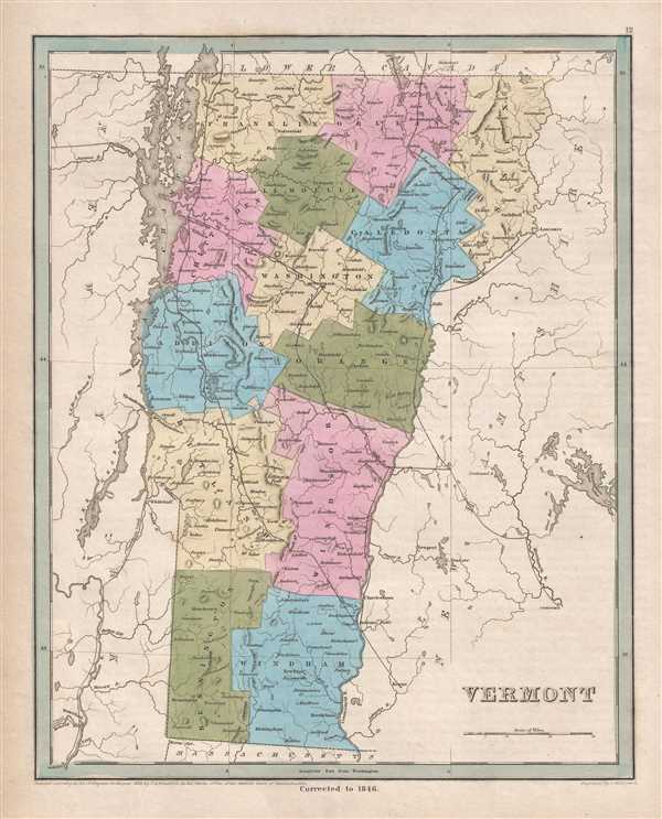
This is an 1846 Thomas G. Bradford map of Vermont. The map depicts the region from New York to New Hampshire and from Quebec to Massachusetts. As is prevalent among many maps from Bradford's A Universal Illustrated Atlas, the recently constructed rail network throughout New Hampshire and the surrounding states is highlighted.
Railroads in Vermont in the 1830s and 1840s
During the 1830s and 1840s, there was a significant push to build railroads from Boston across New Hampshire and Vermont to Lake Champlain, because New York State was no longer issuing charters to out-of-state railroad companies that might compete with the Erie Canal. Thus, by building railways through New Hampshire and Vermont, New York could be mostly avoided. It took a threat from companies in Massachusetts and Vermont to completely bypass New Hampshire for political forces in New Hampshire to back down from the anti-rail positions. However, events did not follow the same path in Vermont. The Vermont Railroad Commission was formed in February 1830 to help support the creation and financing of railroad companies in the state. Once political forces in New Hampshire fell into line, two different routes through to Burlington were proposed, both of which are illustrated here: the 'Central Route' and the 'Rutland Route'. Two different proposals for the 'Central Route' are illustrated here: one traveled via Concord and Montpelier to Burlington, and the other via Bellows Falls, Charlestown, and Montpelier to Burlington. The 'Rutland Route' cut across Vermont via Bellows Falls and Rutland to Burlington.
Highly detailed, each county is illustrated, labeled, and shaded a different color to allow for easy differentiation. Numerous cities and towns are labeled, including Montpelier, Rutland, and Burlington. Lake Champlain, depicted in detail, acts as the northern half of Vermont's border with New York. Myriad rivers and lakes are illustrated throughout the state, along with Lake George, the Champlain Canal, and the Hudson River in New York.
This map was engraved by George Boynton and published in the 1846 edition of Bradford and Goodrich's A Universal Illustrated Atlas.
CartographerS
Thomas Gamaliel Bradford (1802 - 1887) was born in Boston, Massachusetts, where he worked as an assistant editor for the Encyclopedia Americana. Bradford's first major cartographic work was his revision and subsequent republishing of an important French geography by Adrian Balbi, Abrege de Geographie published in America as Atlas Designed to Illustrate the Abridgment of Universal Geography, Modern and Ancient. Afterwards Bradford revised and expanded this work into his own important contributions to American cartography, the 1838 An Illustrated Atlas Geographical, Statistical and Historical of the United States and Adjacent Countries. Bradford's cartographic work is significant as among the first to record Texas as an independent nation. In his long career as a map publisher Bradford worked with William Davis Ticknor of Boston, Freeman Hunt of New York, Charles De Silver of Philadelphia, John Hinton, George Washington Boynton, and others. We have been able to discover little of Bradford's personal life. More by this mapmaker...
George Washington Boynton (fl. c. 1830 - 1850) was a Boston based cartographer and map engraver active in the first half of the 19th century. Boynton engraved and compiled maps for numerous publishers including Thomas Bradford, Nathaniel Dearborn, Daniel Adams, and S. G. Goodrich. His most significant work is most likely his engraving of various maps for Bradford's Illustrated Atlas, Geographical, Statistical, and Historical, of the United States and the Adjacent Countries and Universal Illustrated Atlas. He also engraved for the Boston Almanac. In 1835, Boynton is listed as an employee of the Boston Bewick Company, an engraving, stereotype, and printing concern based at no. 47 Court Street, Boston. Little else is known of his life. Learn More...
Source
Bradford, T. G. and Goodrich, S. G., A Universal Illustrated Atlas, exhibiting a Geographical, Statistical, and Historical view of the World, (Boston: Charles D. Strong) 1846.
The Universal Illustrated Atlas is one of the great American atlases of the first half of the 19th century. The atlas was first published in 1838 under the imprint of Charles D. Strong. It replaced and superseded Bradford's earlier smaller format Illustrated Atlas, Geographical, Statistical, and Historical, of the United States and the Adjacent Countries. Numerous reissues of the Universal Illustrated Atlas followed until about 1848. Although there are minor variations between the editions, most contain about 50 maps, the majority of which focus on the United States. Bradford's atlases are significant for recording North America during the Republic of Texas Era. In later editions, particularly the 1846 edition, Bradford illustrates the boom in railroad construction, possibly with the idea that his maps would aid travelers in planning journeys by rail. It was compiled by Thomas Gamaliel Bradford and Samuel Griswold Goodrich with most of the plates engraved by George Washington Boynton (fl. c. 1830 - 1850). Other contributors include Thomas Gordon (1778 - 1848), Fielding Lucas Jr. (1781 - 1854), Samuel Edward Stiles (1844 - 1901), Sherman and Smith (fl. c. 1829 - 1855), and Horace Thayer (1811 - c. 1874).
Condition
Very good. Even overall toning. Blank on verso.
References
Rumsey 0089.009 (1838 edition).