This item has been sold, but you can get on the Waitlist to be notified if another example becomes available, or purchase a digital scan.
1679 Tavernier Map of Vietnam and Southern China - First Edition
vietnamsouthchinasea-tavernier-1679$1,400.00

Title
Carte Faite sur la Lieux Par Daniel Tavernier En Plusieurs Voiages quil a fait au Tonquin.
1679 (undated) 19 x 15.5 in (48.26 x 39.37 cm) 1 : 3900000
1679 (undated) 19 x 15.5 in (48.26 x 39.37 cm) 1 : 3900000
Description
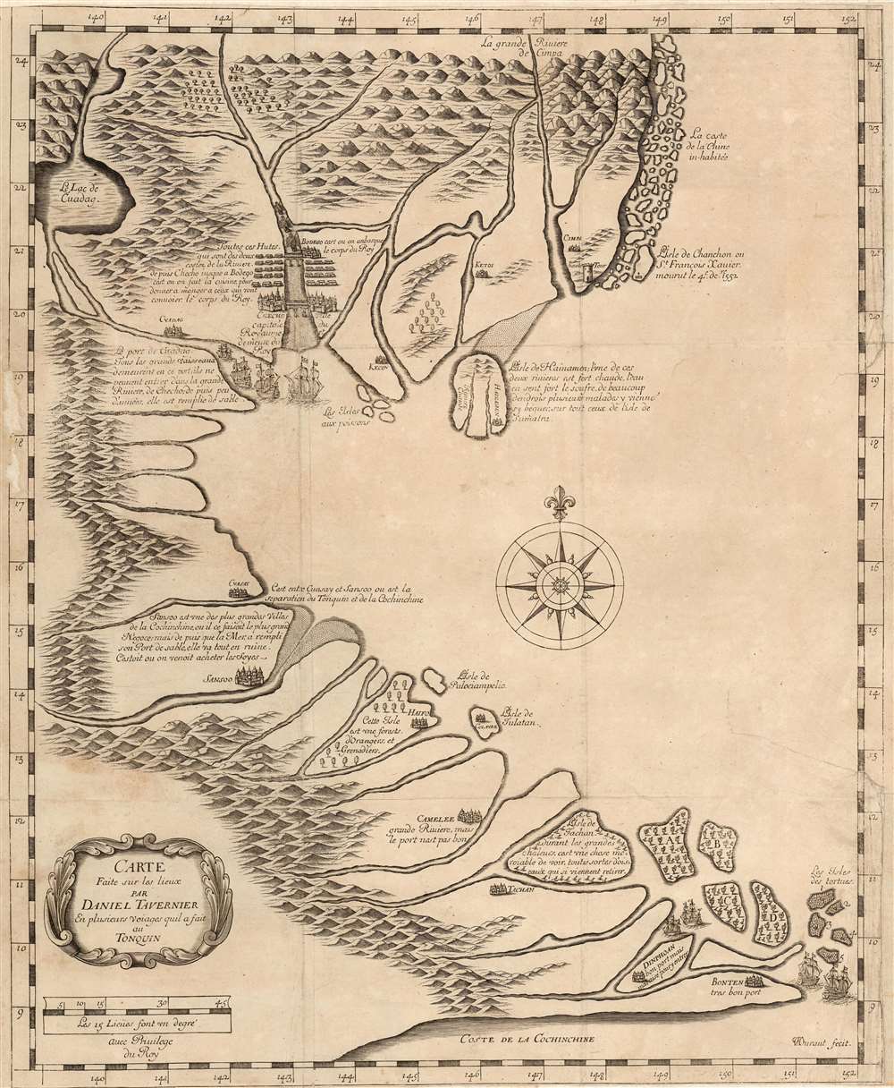
This is a rare, large, 1679 map of Vietnam and Southern China printed by Jean-Baptiste Tavernier and attributed to that mapmaker's elder brother, the French Huguenot merchant adventurer, Daniel Tavernier. The map covers the coast of Vietnam from southern China to the Mekong Delta. It includes parts of modern-day China: the Island of Hainan and the Chinese coast roughly as far north as modern-day Hong Kong and Macau. The Island of Shangchuan (上川岛) appears as well, just south of Hong Kong, where the Navarrese-Basque Roman Catholic missionary, St. Francis Xavier, died.
Tavernier
This map is attributed to Daniel Tavernier, the elusive elder brother of the gem merchant and map publisher Jean-Baptiste Tavernier. Daniel preceded his brother to the orient by at least 10 years and, from his base in the Dutch East India port of Batavia, made 11 or 12 voyages to Tonquin or modern-day northern Vietnam. This map was drawn from his experience and features numerous textual annotations that Suarez suggests contain 'both factual and fanciful' information, but we find most to be very accurate. Annotations describe the famous mineral hot springs of Hainan, the relative navigability of key rivers, and the site of missionary Francis Xavier's death on the Chinese island of Shangchuan. They further make note of the border between the kingdoms of Tonquin (north Vietnam) and Chochine (south Vietnam) in the vicinity of modern-day Hue. The Red River is illustrated prominently, bridged and straddled by Hanoi - here named Checho, by far the most prominent city on the map.Who Owns the South China Sea
Much has been made of this map in relation to modern day trade disputes in the South China Sea between China, Vietnam, and the Philippines. The contested Spratly or Paracel Islands are unfortunately not identified. In fact, although the scope of the map should theoretically cover these islands, the expanse of sea where they lie is instead filled with a compass rose. Nonetheless, this map does cover the South China Sea nearly in full and it is meaningful that this is presented as a 'Map of Tonquin.' Despite covering parts of China, there is no reference to Chinese sovereignty extending south of Hainan.Early China Trade
It does, on the other hand, identify the Côn Đảo Archipelago (Condore Islands) as the Tortues, referencing the abundance of turtles found there. Following their later abandonment of their factory in Hanoi, the English East India Company established a foothold on Pulo Condore as an entrepôt for ships plying the India-China route - soon to be expelled by the Vietnamese. Tavernier's inclusion of the islands here suggests a recognition their strategic value well before the English efforts.Communicative Decorative Elements
Later editions of this map - the Dutch, and the German - fill the empty ocean space with depictions of Neptune on his chariot. In comparison, the ships sailing the waters of this map seem sedate. Their placement, however - sailing around the point of Bonten approaching the Côn Đảo Archipelago, and sailing into the harbor of Cuadag, is significant.Publication History and Census
This map was engraved by Jean-Louis Durant and published by Jean-Baptiste Tavernier in his 1679 Recueil de plusieurs relations et traitez singuliers et curieux, the appendix to Jean-Baptiste Tavernier's 1676 Les Six Voyages de Jean Baptiste Tavernier. The map was later re-engraved entirely (to a much smaller plate) for the 1682 Dutch edition of the Tavernier, and again in 1684 to accompany Johann Chrisoph Wagner's Delineatio Provinciarum Pannoniae et Imperii Turcici in Oriente. The 1679 Recueil is well represented in institutional collections, but the separate map only appears in one catalog entry - incorrectly dated - in the Bibliothèque National de France.CartographerS
Daniel Tavernier (c. 1610 – September 10, 1648) was a French adventurer and merchant active in East Asia during the first half of the 17th century. He was born in Antwerp of a French or Flemish Huguenot family which subsequently returned to Paris after the publication of the Edict of Nantes, which promised protection for French Protestants. Daniel is an older brother of the more famous Jean-Baptiste Tavernier (1605 - 1689), who discovered the Tavernier Blue Diamond (Hope Diamond) and pioneered East Asian trade. Daniel is known to have made 11 or 12 voyages to Tonquin (North Vietnam) from Batavia in the Dutch East Indies. Having settled in the Dutch port of Batavia, he preceded Jean-Baptiste to East Asia by at least 10 years. Daniel's presence in Batavia probably inspired Jean-Baptiste to travel there on his second voyage. Daniel probably served as a guide for Jean-Baptiste on his voyage, which included a stop in Vietnam. Daniel Tavernier died in Batavia of dysentery on September 10 of 1648. He never published in his lifetime, but a map either drawn by him, or based upon his journals, was published by his brother, Jean-Baptiste, in 1679. More by this mapmaker...
Jean-Baptiste Tavernier (1605 - 1689) was a French gem merchant, traveler, and adventurer active in India and East Asia in the middle part of the 17th century. Tavernier was born in Paris of a French or Flemish Huguenot family that had emigrated to Antwerp, to escape persecution, and which subsequently returned to Paris after the publication of the Edict of Nantes, which promised protection for French Protestants. Tavernier had a family connection to mapmaking as both his father Gabriel and his uncle Melchior were cartographers and engravers. Nonetheless, despite a natural talent for drawing and engraving, he had an insatiable wanderlust and instead traveled independently to India and Asia where he made his fortune in the gem trade. Tavernier made a total of six voyages to Persia, India, and Asia between 1630 and 1668. Tavernier is best known for the discovery/purchase of the 116-carat Tavernier Blue diamond that he subsequently sold to Louis XIV of France in 1668 for 120,000 livres, the equivalent of 172,000 ounces of pure gold, and a letter of ennoblement. (Five years later, Louis had his court jeweler Jean Pitau recut the stone into the 68 carat French Blue and had it set as a hatpin. The gem was reset by his great-grandson Louis XV in The Medal of The Order of the Golden Fleece, stolen in 1792, and was recut and re-emerged in London 30 years later as The Hope Diamond). A wealthy man from his adventures, Tavernier acquired the Barony of Aubonne, and settled into a life of leisure wherein, to occupy himself he published a narrative of his voyages, along with two maps, as Les Six Voyages de Jean-Baptiste Tavernier (1676). Tavernier died in Moscow in 1689, at the age of eighty-four. There is a persistent and most likely false legend that he died from being torn apart by wild dogs as a result of a curse on the Tavernier Blue (Hope Diamond). He one of three brothers of the French merchant adventurer Daniel Tavernier who also made numerous voyages to East Asia. Learn More...
Jean Louis Durant (1654–1718) was a Swiss-born engraver active in Paris in the 1670s and 1680s. He engraved maps of Vietnam and Japan, and many of the plates for J. B. Tavernier's Recueil de plusieurs relations et traitez singuliers et curieux. Learn More...
Source
Tavernier, Jean-Baptiste, Recueil de plusieurs relations et traitez singuliers et curieux, (Paris), 1679.
Condition
Average. Margins extended at top and bottom not impacting image; margin reinstated at insertion point. Two mends to right in water areas with virtually no loss to border; mended at left with some loss to border only. Else very good.
References
OCLC 495087661. cf Suarez, Thomas, Early mapping of Southeast Asia, (Hong Kong: Periplus) fig 131.