Digital Image: 1679 Tavernier Map of Vietnam and Southern China - First Edition
vietnamsouthchinasea-tavernier-1679_d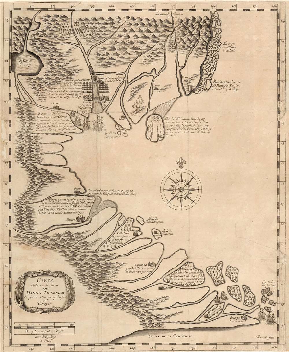

Title
Carte Faite sur la Lieux Par Daniel Tavernier En Plusieurs Voiages quil a fait au Tonquin.
1679 (undated) 19 x 15.5 in (48.26 x 39.37 cm) 1 : 3900000
1679 (undated) 19 x 15.5 in (48.26 x 39.37 cm) 1 : 3900000
Description
FOR THE ORIGINAL ANTIQUE MAP, WITH HISTORICAL ANALYSIS, CLICK HERE.
Digital Map Information
Geographicus maintains an archive of high-resolution rare map scans. We scan our maps at 300 DPI or higher, with newer images being 600 DPI, (either TIFF or JPEG, depending on when the scan was done) which is most cases in suitable for enlargement and printing.
Delivery
Once you purchase our digital scan service, you will receive a download link via email - usually within seconds. Digital orders are delivered as ZIP files, an industry standard file compression protocol that any computer should be able to unpack. Some of our files are very large, and can take some time to download. Most files are saved into your computer's 'Downloads' folder. All delivery is electronic. No physical product is shipped.
Credit and Scope of Use
You can use your digial image any way you want! Our digital images are unrestricted by copyright and can be used, modified, and published freely. The textual description that accompanies the original antique map is not included in the sale of digital images and remains protected by copyright. That said, we put significant care and effort into scanning and editing these maps, and we’d appreciate a credit when possible. Should you wish to credit us, please use the following credit line:
Courtesy of Geographicus Rare Antique Maps (https://www.geographicus.com).
How Large Can I Print?
In general, at 300 DPI, you should at least be able to double the size of the actual image, more so with our 600 DPI images. So, if the original was 10 x 12 inches, you can print at 20 x 24 inches, without quality loss. If your display requirements can accommodate some loss in image quality, you can make it even larger. That being said, no quality of scan will allow you to blow up at 10 x 12 inch map to wall size without significant quality loss. For more information, it is best consult a printer or reprographics specialist.
Refunds
If the high resolution image you ordered is unavailable, we will fully refund your purchase. Otherwise, digital images scans are a service, not a tangible product, and cannot be returned or refunded once the download link is used.
Cartographer S
Daniel Tavernier (c. 1610 – September 10, 1648) was a French adventurer and merchant active in East Asia during the first half of the 17th century. He was born in Antwerp of a French or Flemish Huguenot family which subsequently returned to Paris after the publication of the Edict of Nantes, which promised protection for French Protestants. Daniel is an older brother of the more famous Jean-Baptiste Tavernier (1605 - 1689), who discovered the Tavernier Blue Diamond (Hope Diamond) and pioneered East Asian trade. Daniel is known to have made 11 or 12 voyages to Tonquin (North Vietnam) from Batavia in the Dutch East Indies. Having settled in the Dutch port of Batavia, he preceded Jean-Baptiste to East Asia by at least 10 years. Daniel's presence in Batavia probably inspired Jean-Baptiste to travel there on his second voyage. Daniel probably served as a guide for Jean-Baptiste on his voyage, which included a stop in Vietnam. Daniel Tavernier died in Batavia of dysentery on September 10 of 1648. He never published in his lifetime, but a map either drawn by him, or based upon his journals, was published by his brother, Jean-Baptiste, in 1679. More by this mapmaker...
Jean-Baptiste Tavernier (1605 - 1689) was a French gem merchant, traveler, and adventurer active in India and East Asia in the middle part of the 17th century. Tavernier was born in Paris of a French or Flemish Huguenot family that had emigrated to Antwerp, to escape persecution, and which subsequently returned to Paris after the publication of the Edict of Nantes, which promised protection for French Protestants. Tavernier had a family connection to mapmaking as both his father Gabriel and his uncle Melchior were cartographers and engravers. Nonetheless, despite a natural talent for drawing and engraving, he had an insatiable wanderlust and instead traveled independently to India and Asia where he made his fortune in the gem trade. Tavernier made a total of six voyages to Persia, India, and Asia between 1630 and 1668. Tavernier is best known for the discovery/purchase of the 116-carat Tavernier Blue diamond that he subsequently sold to Louis XIV of France in 1668 for 120,000 livres, the equivalent of 172,000 ounces of pure gold, and a letter of ennoblement. (Five years later, Louis had his court jeweler Jean Pitau recut the stone into the 68 carat French Blue and had it set as a hatpin. The gem was reset by his great-grandson Louis XV in The Medal of The Order of the Golden Fleece, stolen in 1792, and was recut and re-emerged in London 30 years later as The Hope Diamond). A wealthy man from his adventures, Tavernier acquired the Barony of Aubonne, and settled into a life of leisure wherein, to occupy himself he published a narrative of his voyages, along with two maps, as Les Six Voyages de Jean-Baptiste Tavernier (1676). Tavernier died in Moscow in 1689, at the age of eighty-four. There is a persistent and most likely false legend that he died from being torn apart by wild dogs as a result of a curse on the Tavernier Blue (Hope Diamond). He one of three brothers of the French merchant adventurer Daniel Tavernier who also made numerous voyages to East Asia. Learn More...
Jean Louis Durant (1654–1718) was a Swiss-born engraver active in Paris in the 1670s and 1680s. He engraved maps of Vietnam and Japan, and many of the plates for J. B. Tavernier's Recueil de plusieurs relations et traitez singuliers et curieux. Learn More...
Source
Tavernier, Jean-Baptiste, Recueil de plusieurs relations et traitez singuliers et curieux, (Paris), 1679.
References
OCLC 495087661. cf Suarez, Thomas, Early mapping of Southeast Asia, (Hong Kong: Periplus) fig 131.