This item has been sold, but you can get on the Waitlist to be notified if another example becomes available, or purchase a digital scan.
1866 W. P. Upham Map of the Village of Salem, Massachusetts, during the 1692 Witchcraft Trials
VillageofSalem1692-upham-1866$250.00

Title
Map of Salem Village, 1692.
1866 (dated) 11 x 14 in (27.94 x 35.56 cm) 1 : 79200
1866 (dated) 11 x 14 in (27.94 x 35.56 cm) 1 : 79200
Description
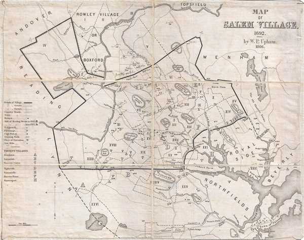
A scarce example of Salem Village, Massachusetts, in 1692, at the height of the infamous Salem Witchcraft Trails by William Phineas Upham. William Phineas Upham prepared this map in 1866 as the frontispiece for his father Charles Wentworth Upham's two-volume 1867 Salem Witchcraft, With an Account of Salem Village and a History of Opinions on Witchcraft and Kindred Spirits, a seminal work on the witchcraft trials.
Here Upham attempts to map the village of Salem as it appeared in 1692 with numerical references for many of the known figures associated with the witchcraft trials. Some 147 individual homes are noted numerically. Numerous important buildings are noted alpha-numerically in the Town of Salem, in the lower right quadrant. The map extends from Andover and Rowley to the Town of Salem and from Humphrey's Pond to Topsfield. The present example includes numerous manuscript annotations in an extremely fine hand identifying the residents of individual homes.
The present example appears not to have accompanied the Charles Wentworth publication and instead to have given as a gift from William Phineas Upham to his friend, Andrew Nichols, a resident of Danvers, Massachusetts. As such it most likely predates the publication of the book, and thus is a scarce separate issue of this desirable map. In it inscribed as such by Upham to Nichols on the verso.
Nichols himself was born in Danvers, Massachusetts, and relocated to Salem, where he graduated from Bowditch High School. He was part of the Insolvency Court of Salem but poor health forced him retire to Danvers and take up farming. Later he moved into the field of engineering and oversaw projects such as the Danvers Water Works and the Peabody Water Works. Andrew Nichols also oversaw the laying out of Valley Road, between Danvers and Topsfield.
Cartographer
William Phineas Upham (January 19, 1836 - November 23, 1905) was a Massachusetts based historian whose work focused on the Salem Witchcraft Trials and local Massachusetts history. William was born into a prestigious family, which included his father, the noted author and historian Charles Wentworth Upham, and the Jurist Oliver Wendell Holmes. Upham's family home was on the site where in 1692, Bridget Bishop was dragged forth to be executed for supposed 'complicity with the powers of evil.' This no doubt influenced his lifelong fascination with the Salem Witchcraft Trials. Upham assisted with his father's Charles Wentworth Upham's opus, Salem Witchcraft, With an Account of Salem Village and a History of Opinions on Witchcraft and Kindred Spirits, producing maps and illustrations to accompany the text. Upham graduated from Harvard and pursued a variety of careers that ranged from school teacher to lawyer, to fireman, to mayor of Salem. Upham was a member of the Massachusetts Historical Society, the Rhode Island Historical Society, the Essex Institute, and the American Historical Association. More by this mapmaker...
Condition
Very good. Dissected and mounted in linen. Sight toning. Manuscript annotation.
References
OCLC 317760499.