This item has been sold, but you can get on the Waitlist to be notified if another example becomes available, or purchase a digital scan.
1906 U.S.C.S. Nautical Chart of Martha's Vineyard / Buzzards Bay, Massachusetts
VineyardSoundBuzzardBay-uscgs-1906$250.00


Title
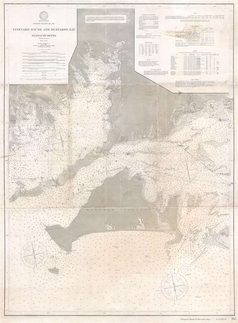
Coast Chart No. 112. Vineyard Sound and Buzzards Bay.
1906 (dated) 38 x 28 in (96.52 x 71.12 cm) 1 : 80000
1906 (dated) 38 x 28 in (96.52 x 71.12 cm) 1 : 80000
Description
This is a 1906 U.S. Coast and Geodetic Survey nautical chart or maritime map of Martha's Vineyard, Buzzards Bay, and Vineyard Sound, Massachusetts. The map depicts from Wareham and Buzzards Bay, Massachusetts to the Atlantic south of Martha's Vineyard and from Cuttyhunk to Hyannis Port. The chart is rich with information essential to the mariner with myriad depth soundings particularly dense along the coastlines. Numerous cities and towns are labeled, including New Bedford, Falmouth, Woods Hole, and several towns on Martha's Vineyard. This chart appears to have been sailed, as it bears manuscript notations, including a course from Martha's Vineyard to Hyannis Port.
Publication History and Census
This 1906 chart was published in Washington D.C. by the U.S. Coast and Geodetic Survey under the supervision of O. H. Tittmann. Its lineage dates back to U.S. Coast Survey hydrographic work completed between 1844 and 1887. The earliest iteration of this chart appeared in 1860. The present plate was produced in 1901, with minor updates and revisions to 1906. Scarce in this edition.Cartographer
The Office of the Coast Survey (1807 - present) founded in 1807 by President Thomas Jefferson and Secretary of Commerce Albert Gallatin, is the oldest scientific organization in the U.S. Federal Government. Jefferson created the "Survey of the Coast," as it was then called, in response to a need for accurate navigational charts of the new nation's coasts and harbors. The spirit of the Coast Survey was defined by its first two superintendents. The first superintendent of the Coast Survey was Swiss immigrant and West Point mathematics professor Ferdinand Hassler. Under the direction of Hassler, from 1816 to 1843, the ideological and scientific foundations for the Coast Survey were established. These included using the most advanced techniques and most sophisticated equipment as well as an unstinting attention to detail. Hassler devised a labor intensive triangulation system whereby the entire coast was divided into a series of enormous triangles. These were in turn subdivided into smaller triangulation units that were then individually surveyed. Employing this exacting technique on such a massive scale had never before been attempted. Consequently, Hassler and the Coast Survey under him developed a reputation for uncompromising dedication to the principles of accuracy and excellence. Unfortunately, despite being a masterful surveyor, Hassler was abrasive and politically unpopular, twice losing congressional funding for the Coast Survey. Nonetheless, Hassler led the Coast Survey until his death in 1843, at which time Alexander Dallas Bache, a great-grandson of Benjamin Franklin, took the helm. Bache was fully dedicated to the principles established by Hassler, but proved more politically astute and successfully lobbied Congress to liberally fund the endeavor. Under the leadership of A. D. Bache, the Coast Survey completed its most important work. Moreover, during his long tenure with the Coast Survey, from 1843 to 1865, Bache was a steadfast advocate of American science and navigation and in fact founded the American Academy of Sciences. Bache was succeeded by Benjamin Pierce who ran the Survey from 1867 to 1874. Pierce was in turn succeeded by Carlile Pollock Patterson who was Superintendent from 1874 to 1881. In 1878, under Patterson's superintendence, the U.S. Coast Survey was reorganized as the U.S. Coast and Geodetic Survey (C & GS) to accommodate topographic as well as nautical surveys. Today the Coast Survey is part of the National Oceanic and Atmospheric Administration or NOAA as the National Geodetic Survey. More by this mapmaker...
Condition
Good. Closed margin tears professionally repaired on verso. Foxing located in upper right corner. Even overall toning. Wear along original fold lines. Blank on verso.