1895 Bureau Topographique Map of Vinh Long, Mekong Delta, Vietnam
VinhLongVietnam-balagny-1895$950.00
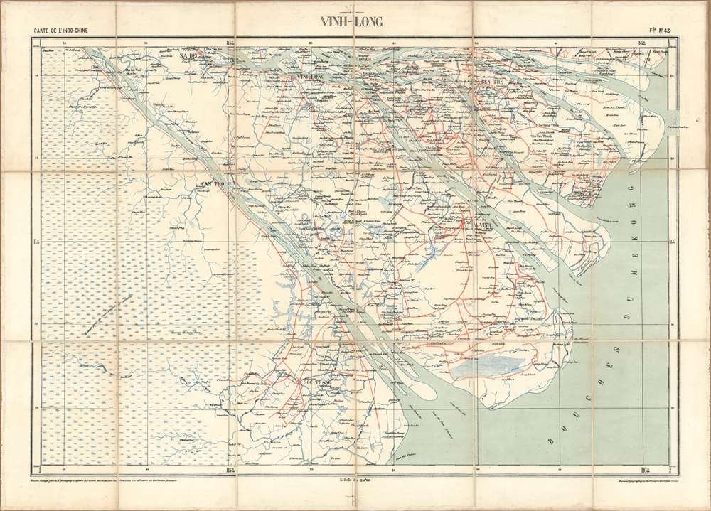

Title
Vinh-Long. / Carte de L'Indo-Chine.
1895 (undated) 24 x 34.25 in (60.96 x 86.995 cm) 1 : 200000
1895 (undated) 24 x 34.25 in (60.96 x 86.995 cm) 1 : 200000
Description
A rare 1895 map of the Vinh-Long region of southern Vietnam, in the sprawling Mekong Delta. The map was issued by the Bureau Topographique des Troupes de l'Indo-Chine and is sheet 43 of the Carte de L'Indo-Chine, an otherwise lost large-scale French military survey of the region. The area covered here, the Mekong Delta and inland as far as the city of Vinh-Long, is considered one of the most beautiful places on Earth. The map is the work of surveys completed between 1886 and 1887 by French topographic officer Dominique Eugène Paul Balagny.
Vinh-Long: The Mekong Delta
Vinh-Long, both the province and the city, are considered to be among the most beautiful in world, known for floating villages, lush jungle, ecological diversity, and vibrant riverside life. The region is flocked by tourists, both local and foreign, doing multi-day excursions from Saigon and Vinh-Long city. The Mekong Delta has been dubbed a 'biological treasure trove'. Over 1,000 animal species were recorded between 1997 and 2007 and new species of plants, fish, lizards, and mammals have been discovered in previously unexplored areas.Carte de L'Indo-Chine
The Carte de L'Indo-Chine is an elusive but impressive military survey of the entirety of French Indo-China published between 1892 and 1895. Presented on a staggering scale of 1:200000, the full set contained over 50 individual sheets. We have been unable to trace any complete sets, with even a search at the Bibliothèque Nationale de France Catalogue Général (BnF) turning up no other examples of this magnificent production. Nor is it clear if the full survey was completed. What we know is that it was issued by the Bureau Topographique des Troupes de l'Indo-Chine based upon surveys completed by Dominique Eugène Paul Balagny (1863 - 1948) between 1889 and 1991, earlier Indo-chine military surveys, and new surveys completed by Bureau expeditionary teams between 1886 and 1893. We have found but one reference to this work, a vague note in an 1898 collection recording the correspondence of the service during the previous 10 years. That note merely suggests that a 1:200000 map was planned as early as 1888. Although all sheets are undated, they were most likely printed in Hanoi after 1890, when the Bureau Topographique acquired a local press. Stylistic variations between maps in the series, for example, how large bodies of water are shaded, suggests that they may have also employed external presses.Publication History and Census
Although undated, this was most likely issued in 1895, in Hanoi, by the Bureau Topographique des Troupes de l'Indo-Chine. The map is sheet no. 43 of a massive 1:200000 topographical survey of Indochina containing at least 50 sheets, of which this is only one of 5 known surviving sheets. No institutional or private holdings have been identified.CartographerS
Bureau Topographique des Troupes de l'Indo-chine (fl. c. 1886 - 1900) was founded in 1886 in Hanoi. Its first major project was a 1:2000000 map of the entirety of Indochina, for which they drew on source maps created by the Service Hydrographique de la Marine and those created by an expeditionary corps sent throughout the region. Before establishing its own printing facilities in Indochina in 1890, the Bureau Topographique transferred their work back to Paris to be printed by the Service Géographique de l'Armée. In 1890 the Bureau Topographique also began to increase its cartographic output. The Bureau Topographique sent army officers on triangulation and topographic missions in unexplored areas of Indochina throughout the 1890s, some of which proved fatal for the participants. It is unclear when the Bureau Topographique shut down, but no examples of their work postdate 1900. More by this mapmaker...
Dominique Eugène Paul Balagny (January 19, 1863 - October 21, 1948), or simply Paul, was a French military officer active in the late 19th and early 20th century. Balagny was born in Bordeaux graduated from the special military school at Saint-Cyr. He was first assigned as a Sub-Lieutenant to the 1er Infanterie Algérienne, then sent to French Indo-China (Vietnam) to serve with the 4e Infanterie du Tonkin. He saw action during the First Annam Insurrection (Cần Vương Movement, 1886). Afterwards, he was assigned to the Bureau Topographique des Troupes de l'Indo Chine. With the bureau he spent 3 years, from 1889 - 1891 surveying the Chinese-Vietnam (Chinese-Annamese) border. After this mission, Balagny crossed the Pacific on the 'City of Peking' with two army friends on a tour around the world, stopping in San Francisco in May of 1892. While there he seems to have spent some time drumming up investment for French mining interests in Tonkin, suggesting that the trip may have had an official component. Just before World War I, from December 31, 1913 - September 8, 1914, he commanded the 65e Régiment d'Infanterie. He was also president of the Société Archéologique, and member of the La Société des Sciences Naturelles de l'Ouest de la France. When he retired from the service, he held the rank of Commandant. Balangy died in Nantes. Learn More...
Condition
Very good. Original linen backing stable.