This item has been sold, but you can get on the Waitlist to be notified if another example becomes available, or purchase a digital scan.
1715 Homann Map of Carolina, Virginia, Maryland and New Jersey
VirginiaMarylandiaCarolina-homann-1715-2$1,350.00

Title
Virginia Marylandia et Carolina in America Septentrionali Britannorum industria excultae…
1715 (undated) 19.75 x 23.5 in (50.165 x 59.69 cm) 1 : 2100000
1715 (undated) 19.75 x 23.5 in (50.165 x 59.69 cm) 1 : 2100000
Description
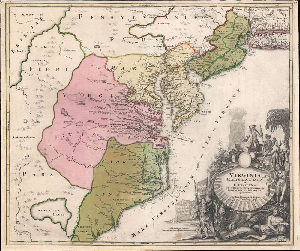
A very handsome example of Johann Baptist Homann's c. 1715 map of Virginia, Carolina, Maryland, and New Jersey; considered one of the most important and decorative maps of this region to appear in the 18th century. Homann drew this map to advocate for Virginia Lieutenant-Governor Alexander Spotswood's 1714 - 1717 plan to settle the little-known interior of Virginia with German immigrants. Shown here is the first mapping of 'Germantown Teutsche Statt' (Germanna) on the Rapidan River, a fork of the Rappahanock River, Fort Christanna (Christ Anna Fort) on the Makharing River, and 'Miester Krugs Plantasie' on the James River. Omission of Spotswood's connection to this map have long led it to being misunderstood or outright dismissed by scholars. Coverage extends from New York City and Long Island south along the Atlantic Cost as far as modern-day Georgia, and as far west as Lake Erie.
Fort Christanna, further south, was built as a bulwark against the French, but also to defend against incursions from French-aligned American Indian groups such as the Tuscarora to the west. Christanna also acted as the headquarters of the Virginia Indian Company, a joint-stock venture founded in 1714 with the intention of trading with indigenous nations.
Spotswood's Plan - Settling Germans in Virginia
While serving as Virginia Lieutenant Governor and de facto governor, Spotswood (1676 - 1740) received numerous land grants in Virginia's interior - then a little-known mountainous region. The intent of the grants was to create a buffer zone against French incursion from to the west. Recognizing potential mineral wealth in the region, Spotswood conceived a plan to entice German miners and ironworkers - then widely recognized as the best in Europe - to settle there. This was not without precedent, as earlier maps and other evidence suggest there were already German settlers in the Shenandoah Valley, such as 'Miester Krugs Plantasie', likely emigres from the German settlements in Pennsylvania just to the north.German Settlements in Virginia
Spotswood began advertising in Germany for potential immigrants and contracted Johann Baptist Homann to make a map highlighting his vision. Here, three towns of potential interest to the German immigrant appear for the first time: 'Germantown Teutsche Statt' (Germanna) on the Rapidan River, a fork of the Rappahanock River; Fort Christanna (Christ Anna Fort) on the Makharing River; and 'Miester Krugs Plantasie' on the James River. Of Master Krug's Plantation, little or nothing is known, but it is believed to pre-date Spotswood's grants. The other two settlements, Germanna and Fort Christanna, are significant. Germanna is the site where most of Spotswood's miners would eventually settle, it is also where Spotswood established his ironworks, and later himself settled, constructing an enormous manor house.Fort Christanna, further south, was built as a bulwark against the French, but also to defend against incursions from French-aligned American Indian groups such as the Tuscarora to the west. Christanna also acted as the headquarters of the Virginia Indian Company, a joint-stock venture founded in 1714 with the intention of trading with indigenous nations.
Knights of the Golden Horseshoe
Little has been said about the mapping of Lake Erie occupying the northwest quadrant. By 1715, the general outline and location of all five Great Lakes was known - but their proportions and latitudinal level was somewhat debated. The influential 1685 Jean Baptiste Louis Franquelin manuscript map places Lake Erie's southernmost shore roughly level with the northern part of the Chesapeake Bay - as shown here. Based upon the best cartography of the time, it was logical to assume one might travel northwest from Virginia only a short distance before reaching Erie. In 1716, Spotswood launched his Knights of the Golden Horseshoe Expedition, in which a band of some 50 prominent Virginians set forth from Germanna to explore that very potential. This was a gentlemanly expedition, lacking all of the horrors commonly associated with new discovery. They are said to have stopped frequently to drink from ample provisions of wine and spirits, not a single explorer was lost, and meetings with American Indian nations were peaceful. They crossed the Blue Ridge Mountains and entered the Shenandoah Valley, claiming it in the name of King George I. They did not reach Lake Erie, but believed that had discovered the route. On return, Spotswood gave expedition members commemorative tokens in the shape of a golden horseshoe.Lake Erie?
Spotswood wrote that the expedition's goal was to discovery a route to Lake Erie, which he believed to be both close and accessible. On this map it is separated from Germanna by a narrow range of mountains (the Blue Ridge?), beyond which rivers flow directly into the Lake. This intervening territory he attaches to 'Florida'. The occupants of this region were mostly American Indian nations loosely allied to French Louisiana. Weather Homann is here using 'Spanish Florida' to undermine French claims, OR, referencing 'French Florida' claims dating to the 16th century, in unclear. Either way, discovering such a route would certainly make settlement more appealing, giving access to more markets and trade, as well as thwarting the growing French influence. Spotswood later sought sanction and funding from King George I to make a second expedition, establish a trade route, and build an outpost on Lake Eire; but permission was never granted.New Mapping Meets Old
Although Homann's remarkable representation of Spottswood's plan is extraordinarily up-to-date considering that Fort Christanna was founded around the same year this map was initially published, the remainder of the map embraces a number of common misconceptions and cartographic inaccuracies. Probably the most notable of these is his inclusion of Apalache Lacus. This fictional lake, the source of the May River, appeared on maps of this region since the 1591 Le Moyne-De Bry map and was popularized by the Mercator/Hondius map of 1606. The apocryphal lake remained on maps well into the mid-18th century before exploration and settlement disproved it.More on the Map
Homann offers a wealth of detail along the Atlantic coast, where most of the European colonization efforts were focused. From Long Island, south to Craven County, Carolina, countless towns and cities are identified. New York City is mapped on the southern tip of Manhattan Island, but is not specifically labeled. New Jersey is divided into the colonial provinces of East New Jersey and West New Jersey. Curiously, Homann maps a large inland lake 'Zuyd Lac' straddling the New Jersey - Pennsylvania border. This is no doubt an early interpretation of the natural widening of the Delaware River at the Delaware Water Gap. Heading south along the Delaware River, Philadelphia is identified and beautifully rendered as a grid embraced in four quadrants. Both the Delaware Bay and the Chesapeake Bay are engraved in full and include submarine features and depth soundings. In Virginia and Carolina, the river systems are surprisingly well mapped, and a primitive county structure is beginning to emerge. The early Virginia counties of Rappahannock, Henrico, City, Isle of Wright, Nansemond, Northumberland, Middlesex, Gloster, and Corotvk are noted. Similarly, in Carolina a number of counties are named, most of which refer to the Lords Proprietors, including Albemarle, Clarenden, and Craven. Cape Fear, Cape Lookout, and Cape Hattaras are noted, and a number of anchorages, reefs, and depth soundings appear.The Dramatic Cartouche
The lower right is occupied by a fabulous decorative title cartouche. Centered on an enormous scallop shell bearing the map's title, the cartouche features American Indians trading with a European gentleman bearing a striking resemblance to Spotswood. The wealth of the region is expressed by an abundance of fish, game, and other trade products. Curling behind the scallop shell is a gigantic stylized alligator resembling nothing so much as a mediaeval dragon.Publication History and Census
Published by J.B. Homann both as a separate issue and in his Atlas Novus. There is unfortunately no definitive publication date for this map, although most date the first issue to about 1715. This would postdate the 1714 first wave of German immigrants under Spotswood's plan, but pre-date the second 1717 wave. None of the locations discovered by 1716 Knights of the Golden Horseshoe Expedition are named, suggested it pre-dated that expedition, thus 1715 is likely correct. The plates for the map wore out quickly, so most examples exhibit a weak impression. The strong impression here suggests an early strike off the plate. This map appeared in various Homann atlases from about 1715 to 1730.Cartographer
Johann Baptist Homann (March 20, 1664 - July 1, 1724) was the most prominent and prolific map publisher of the 18th century. Homann was born in Oberkammlach, a small town near Kammlach, Bavaria, Germany. As a young man, Homann studied in a Jesuit school and nursed ambitions of becoming a Dominican priest. Nonetheless, he converted to Protestantism in 1687, when he was 23. It is not clear where he mastered engraving, but we believe it may have been in Amsterdam. Homann's earliest work we have identified is about 1689, and already exhibits a high degree of mastery. Around 1691, Homann moved to Nuremberg and registered as a notary. By this time, he was already making maps, and very good ones at that. He produced a map of the environs of Nürnberg in 1691/92, which suggests he was already a master engraver. Around 1693, Homann briefly relocated to Vienna, where he lived and studied printing and copper plate engraving until 1695. Until 1702, he worked in Nuremberg in the map trade under Jacob von Sandrart (1630 - 1708) and then David Funck (1642 - 1709). Afterward, he returned to Nuremberg, where, in 1702, he founded the commercial publishing firm that would bear his name. In the next five years, Homann produced hundreds of maps and developed a distinctive style characterized by heavy, detailed engraving, elaborate allegorical cartouche work, and vivid hand color. Due to the lower cost of printing in Germany, the Homann firm could undercut the dominant French and Dutch publishing houses while matching their diversity and quality. Despite copious output, Homann did not release his first major atlas until the 33-map Neuer Atlas of 1707, followed by a 60-map edition of 1710. By 1715, Homann's rising star caught the attention of the Holy Roman Emperor Charles VI, who appointed him Imperial Cartographer. In the same year, he was also appointed a member of the Royal Academy of Sciences in Berlin. Homann's prestigious title came with several significant advantages, including access to the most up-to-date cartographic information as well as the 'Privilege'. The Privilege was a type of early copyright offered to very few by the Holy Roman Emperor. Though less sophisticated than modern copyright legislation, the Privilege offered limited protection for several years. Most all J. B. Homann maps printed between 1715 and 1730 bear the inscription 'Cum Priviligio' or some variation. Following Homann's death in 1724, the firm's map plates and management passed to his son, Johann Christoph Homann (1703 - 1730). J. C. Homann, perhaps realizing that he would not long survive his father, stipulated in his will that the company would be inherited by his two head managers, Johann Georg Ebersberger (1695 - 1760) and Johann Michael Franz (1700 - 1761), and that it would publish only under the name 'Homann Heirs'. This designation, in various forms (Homannsche Heirs, Heritiers de Homann, Lat Homannianos Herod, Homannschen Erben, etc.) appears on maps from about 1731 onwards. The firm continued to publish maps in ever-diminishing quantities until the death of its last owner, Christoph Franz Fembo (1781 - 1848). More by this mapmaker...
Source
Homann, J. B., Neuer Atlas bestehend in einig curieusen Astronomischen Kuppren und vielen auserlesenen accuratensten Land-Charten über die Gantze Welt, (Nuremberg: Homann), 1716.
Homann's Neuer Atlas bestehend in einig curieusen Astronomischen Kuppren und vielen auserlesenen accuratensten Land-Charten über die Gantze Welt was first publihsed in 1707 with 33 maps. A second edition followed in 1710 with 60 maps. Subsequent editions followed until about 1730. The title page notes proudly that the atlas features measurements based on the 'Copernican principle of the moving sky', a truly state-of-the-art innovation for the period. Regardless of editions, collations of the atlas are inconsistent, with some examples having less, while others have more maps - a consequence of the fact that the map sheets were delivered loose, to be bound at the buyer's discretion, and so some buyers chose to omit maps they did not consider relevant, or add others they did. Between editions, the constituent maps, particularly of European regions, were regularly updated to reflect the most recent political events. The atlas continued to be published by Homann's son, J. C. Homann (1703 - 1730), and then by Homann Heirs. Most examples also feature a fine allegorical frontispiece with the title Atlas Novus Terrarum Orbis Imperia, regna et Status, which was used for multiple Homann atlases, including the Neuer Atlas and the Atlas Minor.
Condition
Very good. Strong strike. Contemporary wash color.
References
Rumsey 9753.107. OCLC 5404232. Cumming, W., The Southeast in Early Maps, 156. Pritchard. M. B. and Taliaferro, H., Degrees of Latitude pp. 106 - 109.