This item has been sold, but you can get on the Waitlist to be notified if another example becomes available, or purchase a digital scan.
1715 Homann Map of Carolina, Virginia, Maryland and New Jersey
VirginiaMarylandiaCarolina3-homann-1715$1,150.00

Title
Virginia Marylandia et Carolina in America Septentrionali Britannorum industria excultae…
1714 (undated) 19.75 x 23.5 in (50.165 x 59.69 cm) 1 : 2100000
1714 (undated) 19.75 x 23.5 in (50.165 x 59.69 cm) 1 : 2100000
Description
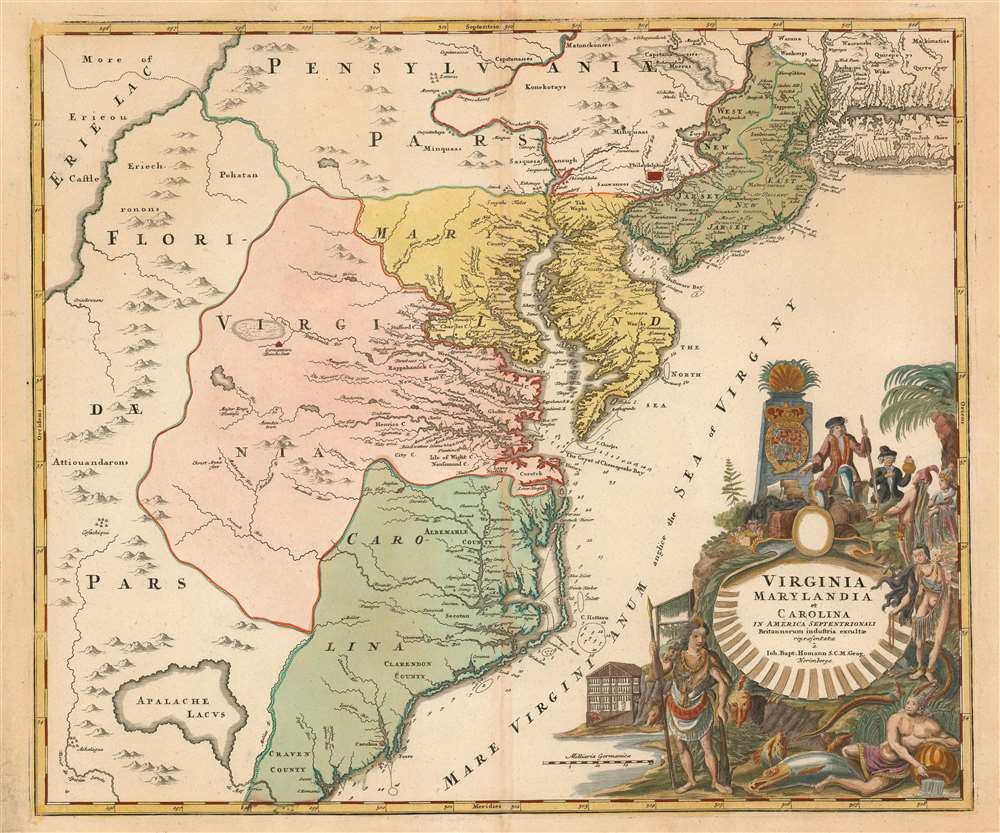
A very handsome example of Johann Baptist Homann's c. 1715 map of Virginia, Carolina, Maryland, and New Jersey; considered one of the most important and decorative maps of is region to appear in the 18th century. This fine map covers from New York City and Long Island south along the Atlantic Cost as far as modern day Georgia, and as far west as Lake Erie. Homann drew this map to support of Virginia Lieutenant-Governor Alexander Spotswood's plan to settle the little known interior of Virginia with German immigrants. Shown here is the first mapping of 'Germantown Teutsche Statt' on the Rappahanock River and Fort Christanna (Christ Anna Fort) on the Makharing River. Fort Christanna was built with the intention of defending the region against incursions from hostile American Indian groups such as the Tuscarora to the west. Christanna also acted as the headquarters of the Virginia Indian Company, a joint-stock venture founded in 1714 with the intention of trading with indigenous groups in the interior
Homann offers a wealth of detail along the Atlantic coast, where most of the European colonization efforts were focused. From Long Island, about two-thirds of which is shown, south to Craven County, Carolina, countless towns and cities are identified. New York City is mapped on the southern tip of Manhattan Island, but is not specifically labeled. New Jersey is divided into the colonial provinces of East New Jersey and West New Jersey. Curiously Homann maps a large inland lake 'Zuyd Lac' straddling the New Jersey - Pennsylvania border. This is no doubt an early misinterpretation of the natural widening of the Delaware River at the Delaware Water Gap. Heading south along the Delaware River Philadelphia is identified and beautifully rendered as a grid embraced in four quadrants. Both the Delaware Bay and the Chesapeake Bay are engraved in full and even include a number of undersea notations and depth soundings. In Virginia and Carolina, the river systems are surprisingly well mapped and a primitive county structure is beginning to emerge. The early Virginia counties of Rappahannock, Henrico, City, Isle of Wright, Nansemond, Northumberland, Middlesex, Gloster and Corotvk are noted. Similarly, in Carolina a number of counties are named, most of which refer to the Lords Proprietors, including Albemarle, Clarenden, and Craven. Cape Fear, Cape Lookout, and Cape Hattaras are noted and a number of anchorages, reefs, and depth sounding are noted along the entire coastline.
New Mapping Meets Old
Although Homann's remarkable representation of Spottswood's plan is extraordinarily up-to-date considering that Fort Christana was founded in the same year that this map was initially published, the remainder of the map embraces a number of common misconceptions and cartographic inaccuracies common to the region. Probably the most notable of these is his inclusion of Apalache Lacus. This fictional lake, the source of the May River, appeared on maps of this region since the mid 16th century Le Moyne-De Bry map and was popularized by the Mercator/Hondius map of 1606. The apocryphal lake would remain on maps well into the mid-18th century before exploration and settlement disproved the theory. Further north Lake Erie and been expanded dramatically and shifted somewhat to the south where it takes on the appearance of a vast inland sea occupying the entire northwestern quadrant of the map. This region, west of the English colonies and north as far as Pennsylvania, Homann attaches to the Spanish claims in Florida.Homann offers a wealth of detail along the Atlantic coast, where most of the European colonization efforts were focused. From Long Island, about two-thirds of which is shown, south to Craven County, Carolina, countless towns and cities are identified. New York City is mapped on the southern tip of Manhattan Island, but is not specifically labeled. New Jersey is divided into the colonial provinces of East New Jersey and West New Jersey. Curiously Homann maps a large inland lake 'Zuyd Lac' straddling the New Jersey - Pennsylvania border. This is no doubt an early misinterpretation of the natural widening of the Delaware River at the Delaware Water Gap. Heading south along the Delaware River Philadelphia is identified and beautifully rendered as a grid embraced in four quadrants. Both the Delaware Bay and the Chesapeake Bay are engraved in full and even include a number of undersea notations and depth soundings. In Virginia and Carolina, the river systems are surprisingly well mapped and a primitive county structure is beginning to emerge. The early Virginia counties of Rappahannock, Henrico, City, Isle of Wright, Nansemond, Northumberland, Middlesex, Gloster and Corotvk are noted. Similarly, in Carolina a number of counties are named, most of which refer to the Lords Proprietors, including Albemarle, Clarenden, and Craven. Cape Fear, Cape Lookout, and Cape Hattaras are noted and a number of anchorages, reefs, and depth sounding are noted along the entire coastline.
The Dramatic Cartouche
The lower right quadrant of this map is occupied by a fabulous decorative title cartouche. Centered on an enormous scallop shell bearing the map's title, the cartouche features a number of stylized American Indians trading with European merchants. The wealth of the region is expressed by an abundance of fish, game, and other trade products. Curling behind the scallop shell is a gigantic stylized alligator looking like nothing so much as a mediaeval dragon.Publication History and Census
Published by J.B. Homann in his Atlas Novus. This map appeared in various Homann atlases from about 1714 to 1730.Cartographer
Johann Baptist Homann (March 20, 1664 - July 1, 1724) was the most prominent and prolific map publisher of the 18th century. Homann was born in Oberkammlach, a small town near Kammlach, Bavaria, Germany. As a young man, Homann studied in a Jesuit school and nursed ambitions of becoming a Dominican priest. Nonetheless, he converted to Protestantism in 1687, when he was 23. It is not clear where he mastered engraving, but we believe it may have been in Amsterdam. Homann's earliest work we have identified is about 1689, and already exhibits a high degree of mastery. Around 1691, Homann moved to Nuremberg and registered as a notary. By this time, he was already making maps, and very good ones at that. He produced a map of the environs of Nürnberg in 1691/92, which suggests he was already a master engraver. Around 1693, Homann briefly relocated to Vienna, where he lived and studied printing and copper plate engraving until 1695. Until 1702, he worked in Nuremberg in the map trade under Jacob von Sandrart (1630 - 1708) and then David Funck (1642 - 1709). Afterward, he returned to Nuremberg, where, in 1702, he founded the commercial publishing firm that would bear his name. In the next five years, Homann produced hundreds of maps and developed a distinctive style characterized by heavy, detailed engraving, elaborate allegorical cartouche work, and vivid hand color. Due to the lower cost of printing in Germany, the Homann firm could undercut the dominant French and Dutch publishing houses while matching their diversity and quality. Despite copious output, Homann did not release his first major atlas until the 33-map Neuer Atlas of 1707, followed by a 60-map edition of 1710. By 1715, Homann's rising star caught the attention of the Holy Roman Emperor Charles VI, who appointed him Imperial Cartographer. In the same year, he was also appointed a member of the Royal Academy of Sciences in Berlin. Homann's prestigious title came with several significant advantages, including access to the most up-to-date cartographic information as well as the 'Privilege'. The Privilege was a type of early copyright offered to very few by the Holy Roman Emperor. Though less sophisticated than modern copyright legislation, the Privilege offered limited protection for several years. Most all J. B. Homann maps printed between 1715 and 1730 bear the inscription 'Cum Priviligio' or some variation. Following Homann's death in 1724, the firm's map plates and management passed to his son, Johann Christoph Homann (1703 - 1730). J. C. Homann, perhaps realizing that he would not long survive his father, stipulated in his will that the company would be inherited by his two head managers, Johann Georg Ebersberger (1695 - 1760) and Johann Michael Franz (1700 - 1761), and that it would publish only under the name 'Homann Heirs'. This designation, in various forms (Homannsche Heirs, Heritiers de Homann, Lat Homannianos Herod, Homannschen Erben, etc.) appears on maps from about 1731 onwards. The firm continued to publish maps in ever-diminishing quantities until the death of its last owner, Christoph Franz Fembo (1781 - 1848). More by this mapmaker...
Source
Homann, J. B., Neuer Atlas bestehend in einig curieusen Astronomischen Kuppren und vielen auserlesenen accuratensten Land-Charten über die Gantze Welt, (Nuremberg: Homann), 1716.
Homann's Neuer Atlas bestehend in einig curieusen Astronomischen Kuppren und vielen auserlesenen accuratensten Land-Charten über die Gantze Welt was first publihsed in 1707 with 33 maps. A second edition followed in 1710 with 60 maps. Subsequent editions followed until about 1730. The title page notes proudly that the atlas features measurements based on the 'Copernican principle of the moving sky', a truly state-of-the-art innovation for the period. Regardless of editions, collations of the atlas are inconsistent, with some examples having less, while others have more maps - a consequence of the fact that the map sheets were delivered loose, to be bound at the buyer's discretion, and so some buyers chose to omit maps they did not consider relevant, or add others they did. Between editions, the constituent maps, particularly of European regions, were regularly updated to reflect the most recent political events. The atlas continued to be published by Homann's son, J. C. Homann (1703 - 1730), and then by Homann Heirs. Most examples also feature a fine allegorical frontispiece with the title Atlas Novus Terrarum Orbis Imperia, regna et Status, which was used for multiple Homann atlases, including the Neuer Atlas and the Atlas Minor.
Condition
Very good. Minor marginal toning and wear; contemporary wash color, refreshed.
References
cfRumsey9753.107. OCLC 5404232. On The Map, Fig. 27. Cumming 156. Pritchard. M.B. & Taliaferro, H. Degrees of Latitude pp. 106-109.