This item has been sold, but you can get on the Waitlist to be notified if another example becomes available, or purchase a digital scan.
1945 NEWSMAP and Richard Edes Harrison Map of Japan from Siberia
VolIVNo3FOverseas-newsmap-1945$137.50


Title
Japan from Siberia. / Newsmap Overseas Edition. For the Armed Forces. 295th Week of the War 177th Week of U.S. participation. Monday, 14 May, 1945. Week of 24 April to 1 May. Volume IV No. 3F.
1945 (dated) 17.25 x 23.125 in (43.815 x 58.7375 cm)
1945 (dated) 17.25 x 23.125 in (43.815 x 58.7375 cm)
Description
This is a 1945 Army Orientation Branch Newsmap map of Japan in the scarce Overseas Edition. Published on Monday, May 14, 1945, this piece was distributed after Germany surrendered and the war in Europe had ended. The Army Orientation Branch utilizes the work of celebrated cartographer Richard Edes Harrison to highlight Japan, the only remaining Axis power, on the recto. On the verso, the historic linkup between the American Army and the Soviet Red Army is celebrated.
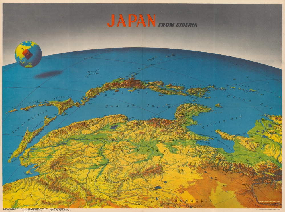
Japan from Siberia
A stunning stylized view, this incredible work was created by Richard Edes Harrison in 1943 for TIME Magazine. Drawn from the perspective of being high above Siberia, Siberia, Mongolia, Manchuria, and Korea stretch out in the foreground before the viewer. The Sea of Japan breaks up the landmass before the viewer encounters the arch of the Japanese home islands. Honshu acts as the focal point, with its central mountains appearing in incredible perspective. Hokkaido and the Kurile Islands are to the left, while Shikoku, Kyushu, and the Ryukyu Islands stretch out to the right. The Pacific Ocean then extends out to the horizon, with the curvature of the Earth clearly illustrated. Harrison depicts continental Asia's impressive topography in stunning fashion, identifying mountain ranges and using color to highlight river valleys.U.S.-Soviet Armies Join
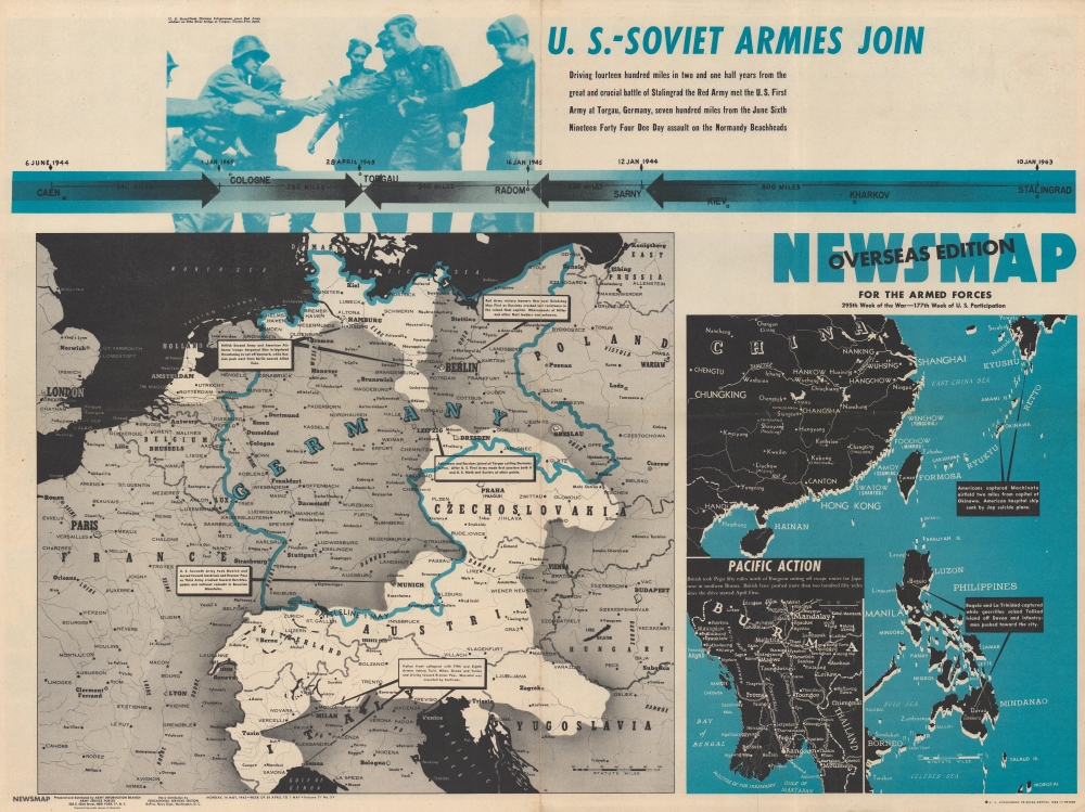
The verso focuses on the linkup between the Soviet Red Army and the U.S. First Army at Torgau, Germany. A map of central Europe dominates the sheet with white highlighting the only territory left not conquered by either the Soviets from the East or the British and Americans from the west. Small text boxes highlight the latest victories in Italy and Germany, along with the Red Army victory banners flying over the Reichstag in Berlin. A photograph of Soviet and American soldiers shaking hands at Torgau appears above the map, along with a graphic detailing the distances covered by American and Soviet to their historic meeting point. A smaller map on the lower right illustrates from Kyushu south to the Celebes Sea and textboxes inform the viewer of American progress on Okinawa and American and Filipino victories in the Philippines. An inset proclaims the progress of the British in Burma.Publication History and Census
This Newsmap was prepared and distributed by the Army Information Branch in May 1945. The map of Japan on the recto was drawn by Richard Edes Harrison and originally published in TIME Magazine in 1943. The Army Information Branch used this specific Harrison map on at least one other Newsmap: Vol III No. 3B published in 1944. At least two editions of this edition of this Newsmap were published: a smaller overseas edition meant for troops deployed overseas and a large-format wall map distributed to domestic military installations throughout the United States. This is the only known cataloged example of the Overseas Edition, which we believe had an overall lower survival rate than the larger domestic edition. We note 7 examples of the domestic edition cataloged in OCLC as well as an example in the collection at the University of North Texas.CartographerS
The Army Orientation Branch (1940 - c. 1949) created special maps for teaching the Army Orientation Course and was based at The Pentagon in Washington, D.C. The Army Orientation Branch was part of the Information and Education Division. More by this mapmaker...
Richard Edes Harrison (1902 - January 5, 1994) was an American cartographer and cartoonist active in the middle part of the 20th century. Harrison is credited with redefining cartography, especially journalistic cartography, by employing spherical perspective, bold shading, and graphic design to both make maps more publicly accessible and give them an artistic dimension. Harrison was born in Baltimore and studied design at Yale, graduating in 1923, before relocating to New York City at the height of the Great Depression. He made ends meet through industrial design work, creating everything from bottles to ashtrays. His first foray into the cartographic world was a fill-in job at Fortune magazine. The editors at Fortune must have admired his work for it launched a long-standing collaboration. His work, doubtless inspired by the age of air travel, became exceptionally popular during World War II, where his unique approach and political charged subject matter illustrated the seats of war with exceptional poignancy and clarity. After the war, Harrison continued to produce maps from his base in New York City. In his spare time he was an avid ornithologist and was commonly seen in Central Park in search of rare bird sightings. Learn More...
Source
Newsmap series.
Newsmaps were published weekly between April 1942 and March 1946. Their content usually featured world maps, short summaries of the week’s military action, and photographs of troops and materiel. Early Newsmaps were printed on one side only, but, later in the war, they were printed on both sides, with the reverse bearing large-format maps, photographs, or other visual information. Several different versions of Newsmaps were produced: a large domestic version, a smaller overseas version, and an industrial version, which included more information about war production efforts. Two other editions appear in the United States Government Publications Monthly Catalogs, a 'Newsmap Special Edition' and a 'Newsmap Special Supplement for Special Training Units'.
Per the National Archives and Records Administration, ‘NEWSMAPS were not issued for general distribution. The posters were distributed to military installations, government and civilian groups working on War Department projects, and certain depository libraries, as designate by Congress, and one copy to Congressmen, if requested.’ The importance of the Newsmaps to the Army is related in the 1944 Basic Field Manual for The Special Service Company. The Manual states that as soon as the company reaches its destination ‘the company commander should contact the Special Service Branch in theater of operations headquarters, for copies of the weekly Newsmap.’ Also per the Manual
Per the National Archives and Records Administration, ‘NEWSMAPS were not issued for general distribution. The posters were distributed to military installations, government and civilian groups working on War Department projects, and certain depository libraries, as designate by Congress, and one copy to Congressmen, if requested.’ The importance of the Newsmaps to the Army is related in the 1944 Basic Field Manual for The Special Service Company. The Manual states that as soon as the company reaches its destination ‘the company commander should contact the Special Service Branch in theater of operations headquarters, for copies of the weekly Newsmap.’ Also per the Manual
The librarian should check the weekly Newsmap as soon as it is made available and should post it in a conspicuous place. He should take steps to see that the place where the Newsmap is posted is made known to all troops of the area in which the company or platoon is operating. This can be done effectively through notices in soldier newspapers, verbal announcements by those directly in charge of troops, and by posting announcements on bulletin boards.
Condition
Very good. Light wear along original fold lines. Verso repairs in margins to fold separations.