This item has been sold, but you can get on the Waitlist to be notified if another example becomes available.
1870 Colton Large Format Map of Washington Territory
Washington-colton-1870$4,000.00

Title
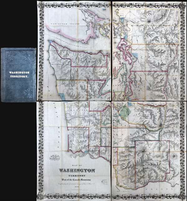
Map of Washington Territory West of the Cascade Mountains Compiled by the Government Surveys by Chas. A. White. C. E.
1870 (dated) 65 x 49 in (165.1 x 124.46 cm) 1 : 253440
1870 (dated) 65 x 49 in (165.1 x 124.46 cm) 1 : 253440
Description
A landmark production, this is the first large format commercially issued map of Washington Territory. It was issued by Charles A. White, woring with George Woolworth and Charles B. Colton, in 1870. The Colton brothers doubtless intended the map to capitalize on general interest in the region stemming from the imminent construction of the Northern Pacific Railroad. Although the Northern Pacific had been delayed for many years, construction finally began in 1870 and brought with it the promise of a land rush and an associated trade explosion to this previously remote and inaccessible part of the country.
Washington Territory Land Rush
The map's coverage extends from Vancouver to the Columbia River and from the Pacific to the Cascade Mountains. The region's rich topography is illustrated via shading and hachure. Cartographically, this map based upon the U.S. Government Land Surveys and the United States Coast Survey. The platting work of the U.S. Land Survey for Washington Territory is evident throughout in the form of small and large squares. Some of this land had clearly been assigned and color coding indicates Prairie Lands (Green), Government Reserves (Red), and Indian Reservations (Light Blue). Among other things, the prevalence of largely unassigned plats indicates the extraordinary wealth of excellent land available to enterprising pioneer settlers. Between 1870, when his map was issued, and 1880, the population of Washington Territory over tripped, from about 23,500 to 75,000
Charles A. White
The title attributes the compilation to Charles A. White, Civil Engineer. Historically, this has been assumed to be Charles Abiathar White, an Iowa geologist and surveyor. Recent scholarship, however, suggested that the imprint referrers to Charles A. White, a civil engineer based in Olympia, Washington. C. A. White was born in Sweden in 1830 - 1898).The Northern Pacific Railroad
The Coltons, who built their mapmaking empire on anticipating the growing of the American Rail network, were probably a little premature in the production of this grand plan. Although construction for the Northern Pacific Route did in fact begin in earnest in 1870, the network was not completed until 1883 when the Golden Spike was driven in western Montana. By that time, the railroad itself had produced far more accurate maps of the region and this Colton/White masterpiece was forgotten.Publication History and Census
This map was published by Charles A. White in 1870. There are two states of the map, both issued in 1870, just a few months apart, but with multiple minor revisions and updates. The second and rarer edition is most easily recognized by the assignation of the copyright to Hazard Stevens - this is not evident on the first state. Today this map is extremely rare. A few examples do survive in institutional collections, but it is uncommon to the market. This is an essential map for any collection focused on the cartographic development of the Pacific Northwest.CartographerS
Joseph Hutchins Colton (July 5, 1800 - July 29, 1893), often publishing as J. H. Colton, was an important American map and atlas publisher active from 1833 to 1897. Colton's firm arose from humble beginnings when he moved to New York in 1831 and befriended the established engraver, Samuel Stiles. He worked under Stiles as the 'Co.' in Stiles and Co. from 1833 to 1836. Colton quickly recognized an emerging market in railroad maps and immigrant guides. Not a cartographer or engraver himself, Colton's initial business practice mostly involved purchasing the copyrights of other cartographers, most notably David H. Burr, and reissuing them with updated engraving and border work. His first maps, produced in 1833, were based on earlier Burr maps and depicted New York State and New York City. Between 1833 and 1855, Colton proceeded to publish a large corpus of guidebooks and railroad maps, which proved popular. In the early 1850s, Colton brought his two sons, George Woolworth Colton (1827 - 1901) and Charles B. Colton (1832 - 1916), into the map business. G. W. Colton, trained as a cartographer and engraver, was particularly inspired by the idea of creating a large and detailed world atlas to compete with established European firms for the U.S. market. In 1855, G.W. Colton issued volume one of the impressive two-volume Colton's Atlas of the World. Volume two followed a year later. Possibly because of the expense of purchasing a two-volume atlas set, the sales of the Atlas of the World did not meet Colton's expectations, and so, in 1856, the firm also issued the atlas as a single volume. The maps contained in this superb work were all original engravings, and most bear an 1855 copyright. All of the maps were surrounded by an attractive spiral motif border that would become a hallmark of Colton's atlas maps well into the 1880s. In 1857, the slightly smaller Colton's General Atlas replaced the Atlas of the World. Most early editions of the General Atlas published from 1857 to 1859 do not have the trademark Colton spiral border, which was removed to allow the maps to fit into a smaller format volume. Their customers must have missed the border because it was reinstated in 1860 and remained in all subsequent publications of the atlas. There were also darker times ahead; in 1858, Colton was commissioned at a sum of 25,000 USD by the government of Bolivia to produce and deliver 10,000 copies of a large format map of that country. Although Colton completed the contract in good faith, delivering the maps at his own expense, he was never paid by Bolivia, which was at the time in the midst of a series of national revolutions. Colton would spend the remainder of his days fighting with the Bolivian and Peruvian governments over this payment, and in the end, after a congressional intervention, he received as much as 100,000 USD in compensation. Nonetheless, at the time, it was a disastrous blow. J. H. Colton and Company is listed as one of New York's failed companies in the postal record of 1859. This led Colton into the arms of Alvin Jewett Johnson and Ross C. Browning. The 1859 edition of Colton's General Atlas lists Johnson and Browning as the 'Successor's to J. H. Colton' suggesting an outright buyout, but given that both companies continued to publish separately, the reality is likely more complex. Whatever the case may have been, this arrangement gave Johnson and Browning access to many of Colton's map plates and gave birth to Johnson's New Illustrated (Steel Plate) Family Atlas. The Johnson's Atlas was published parallel to Colton's atlases well into the 1880s. The Colton firm itself subsequently published several other atlases including an Atlas of America, the Illustrated Cabinet Atlas, the Octavo Atlas of the Union, and Colton's Quarto Atlas of the World. They also published a large corpus of wall maps, pocket maps, and guides. The last known publications of the Colton firm date to 1897 and include a map and a view, both issued in association with the Merchant's Association of New York. Alice M. Colton married August R. Ohman (May 3, 1859 - April 22, 1934) on January 5, 1897. In 1898, Ohman joined the Colton firm, which continued to publish as Colton, Ohman & Co. until 1901. More by this mapmaker...
Charles A. White (1830 - 1898) was a Swedish-American civil engineer and surveyor active in Washington Territory in the late 19th century. White first appears in Washington in 1859, where is is listed as a 'compassion for Issac Smith and Jared Hurd on Contract 46', an effort to set up townships between Seattle and Everett. By 1864 he was county surveyor for Walla Walla. IN 1870, he was in Olympia, where he produced a large scale map of Washington Territory later published by the Colton firm. This map won first prize at the Thurston County Fair in 1871 and is today considered one of the best and rarest map of of said territory. He became county commissioner of Walla Walla in 1874, where he worked on a Northern Pacific Railroad connection between Olympia and Tenino. He then turned his civil engineering interests to Tacoma, where form 1885 to 1890, he was active. He retired and settled in Seattle in 1892. He died in 1898, the recorded cause 'senile decay.' White pass, near Mount Reiner, is named after him. (Credit for this bio: Surveying North of the River, Second Edition, Volume 1, page 499.) Learn More...
Condition
Very good. Minor wear on original fold lines. Attached to original binder which is split at spine. Can be removed from binder and/or joined as a large wall map on request for an additional fee.
References
Streeter, #3257. Phillips, p. 997. OCLC 1034921905.