This item has been sold, but you can get on the Waitlist to be notified if another example becomes available, or purchase a digital scan.
1902 Plummer Map of Washington State Timber Resources
Washington-plummer-1902$600.00

Title
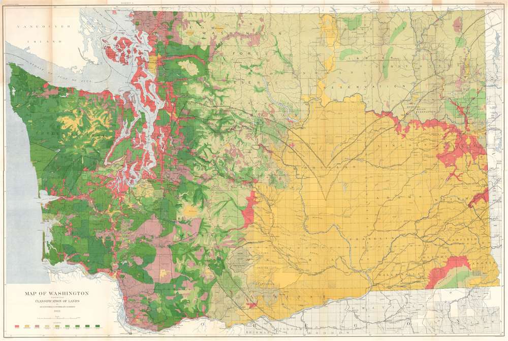
Map of Washington Showing Classification of Lands.
1902 (dated) 41.5 x 62.5 in (105.41 x 158.75 cm) 1 : 396000
1902 (dated) 41.5 x 62.5 in (105.41 x 158.75 cm) 1 : 396000
Description
This is a large, colorful 1902 Map of Washington State showing the distribution and value of its forest lands - at the time, the primary moneymaker for the state. The map is printed in nine shades, showing unforested regions, cut and burned regions, and the density of forested areas. The map has been updated closely since its 1898 edition, showing dramatic re-growth in reserve areas - in particular, the Mount Rainier and the Olympic Jefferson Forest Reserves. Both of these had been established in 1897, and the dramatic changes shown on this map in comparison with the 1898 edition testify to the efficacy of the reserves in permitting the regrowth of heavily lumbered forest. Both of these areas would be made into National Forests in 1907.
Not all of the railways were in service of lumbering. The short-lived Everett and Monte Cristo Railway was built to bring gold and silver from mines in the central Cascade Mountains to Everett, Washington for smelting. The railway began operation in 1893. Although the mining boom ended in 1903, the line stayed active until 1936, fueled by tourist traffic viewing the mountainous scenery.
Railroads
The map shows a number of railroads, whose proliferation was directly connected to the booming lumber trade in Washington. These include the Northern Pacific, the Seattle & Northern Rail Road, the Great Northern Rail Road, the Bellingham and British Colombia Rail Road and the Seattle & International Rail Road. The brief and desperate existence of The Port Townsend Southern Railroad Company is captured on the map (both its northern leg and its abortive terminus at Tenino.)Not all of the railways were in service of lumbering. The short-lived Everett and Monte Cristo Railway was built to bring gold and silver from mines in the central Cascade Mountains to Everett, Washington for smelting. The railway began operation in 1893. Although the mining boom ended in 1903, the line stayed active until 1936, fueled by tourist traffic viewing the mountainous scenery.
Publication History and Census
The map was produced to accompany the U.S. Geological Survey Annual Report, Part V. We find seven examples of the 1902 edition in institutional collections; the 1898 printing is more widely catalogued. The map has been overlooked by the market: we see only one listing of map in a dealer's catalogue in 2009.CartographerS
George Howard Plummer (March 8, 1868 - June 5, 1950) was an American surveyor who worked for the U.S. Geological Survey during the latter part of the 19th century and the early 20th century. He is credited with preparing many different reports and maps for the U.S.G.S. He was married to Emma Lulu Fries. More by this mapmaker...
Frederick Gordon Plummer (October 4, 1864 - August 15, 1913) was an American surveyor, engineer, and geographer. Plummer completed the first comprehensive survey and mapping of the Mount Rainier Forest Reserve in 1899. The following year he published a report that included detailed descriptions of the forest types and conditions, fire history, hydrology, and grazing in the area that would become Gifford Pinchot National Forest. Fred, a Theosophist, moved his family from Tacoma, Washington, to the Theosophical community of Lomaland at Point Loma, California, in 1903, and became the chief geographer of the United States Forestry Service that same year. He was a leader in the conservation movement until his death. Fred and his wife Emily had six children, one of whom, Lafayette Gordon Plummer, became a Theosophical writer, lecturer, and teacher. Learn More...
Julius (Julien) Bien (September 27, 1826 - December 21, 1909) was a German-Jewish lithographer and engraver based in New York City. Bien was born in Naumburg, Germany. He was educated at the Academy of Fine Arts, Cassell and at Städel's Institute, Frankfurt-am-Main. Following the suppression of the anti-autocratic German Revolutions of 1848, Bien, who participated in the pan-German movement, found himself out of favor in his home country and joined the mass German immigration to the United States. Bien can be found in New York as early as 1849. He established the New York Lithographing, Engraving & Printing Company in New York that focused on the emergent chromo-lithograph process - a method of printing color using lithographic plates. His work drew the attention of the U.S. Government Printing Office which contracted him to produce countless government maps and surveys, including the Pacific Railroad Surveys, the census, numerous coast surveys, and various maps relating to the American Civil War. Bien also issued several atlases both privately and in conjunction with a relation, Joseph Bien. At the height of his career Bien was elected president of the American Lithographers Association. After his death in 1909, Bien's firm was taken over by his son who promptly ran it into insolvency. The firm was sold to Sheldon Franklin, who, as part of the deal, retained the right to publish under the Julius Bien imprint. In addition to his work as a printer, Bien was active in the New York German Jewish community. He was director of the New York Hebrew Technical Institute, the New York Hebrew Orphan Asylum, and president of the B'nai B'rith Order. Learn More...
The United States Geological Survey (1878 - Present), aka the U.S.G.S., is a scientific agency of the United States government, which was founded in 1879. USGS scientists study the landscape of the United States, its natural resources, and the natural hazards that threaten it. The organization has four major science disciplines: biology, geography, geology, and hydrology. It is a bureau of the United States Department of the Interior and is the department's only scientific agency. Learn More...
Condition
Good. Verso reinforcements and repairs at nearly all fold intersections. Verso repairs to fold separations. Exhibits minor loss at some fold intersections. Wear along original fold lines. Blank on verso.
References
OCLC 31225964.