1924 Foster and Reynolds City Plan or Map of Washington D.C.
WashingtonDC-fosterreynolds-1924$350.00


Title
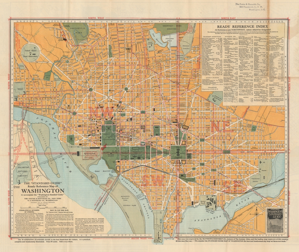
The 'Standard Guide' Ready Reference Map of Washington.
1924 (dated) 19 x 23.25 in (48.26 x 59.055 cm) 1 : 16896
1924 (dated) 19 x 23.25 in (48.26 x 59.055 cm) 1 : 16896
Description
This is a 1924 plan or map of Washington, D.C., by the Foster and Reynolds Company of New York. This map appeared as the District of Columbia was emerging from the shadow of World War I and stepping into the modern era. This map reflects the city's rapid expansion in this period, fueled by the postwar economic boom and the growing federal government.
A Closer Look
It covers Washington D.C. from Arlington National Cemetery and Georgetown College eastward as far as 28th Street and the Congressional Cemetery and from the Soldiers' Home grounds to the Anacostia River and the War College (southern tip of Washington, D.C.).The map is exceptionally detailed, noting important buildings, monuments, streets, parks, railroads, and an assortment of other topographical details. Other sites of note are the United States Navy Yard, Howard University, and the Zoological Park. The National Mall appears as 'The Mall'. A red stamp over the Reflecting Pool between the Lincoln Memorial and the Washington Monument points toward the 'Ask Mr. Foster' information office on 14th Street. The city is divided into four sections marked N.W., S.W., S.E., and N.E. by lines emanating from the Capitol Building. A 'Ready Reference Index' is set in the upper right quadrant. Two short paragraphs in the lower left quadrant detail the geographical divisions of streets and a note on how to use this map.Publication History and Census
This map was engraved by the Matthews-Northrup Company, makers of the Century Atlas, and published in 1924 by Foster and Reynolds. Foster and Reynolds first issued this map in 1901, but regularly revised for the next 25 years. We note 3 examples of the 1924 edition cataloged in OCLC: Library of Congress, the Wisconsin Historical Society, and the University of Arizona.Cartographer
Matthews-Northrup Works (fl. c. 1895 - 1930) were a Buffalo, New York based, in their own words, "writing, designing, engraving, printing, [and] binding" firm. The firm was founded by James Newson Matthews (November 21, 1828 - December 20, 1888) as the J. N. Matthews Company. William Phelps Northrup (April 2, 1850 - February 2, 1929) later joined the company as an apprentice and then partner, at which point the firm was reincorporated as the Matthews-Northrup Works. The Matthews-Northrup Works rose to prominence as publishers and printers of railroad maps, with dozens to their credit. When James died, his shares were inhered by George Edward Matthews (1855 - 1910), who ran the business until his death in 1910. Also in 1910, they famously redesigned the cover of National Geographic Magazine. Despite some six previous cover changes in just 21 years, the Matthews-Northrup layout proved so popular that it was used for nearly 50 years. The firm can also take credit for the Winchell typeface, designed in 1903 under E. E. Winchell's tenure as art director. Curiously, the partners of Matthews-Northrup maintained an unusual affectation in which only the officers of the company could wear beards or mustaches. In this same spirit, the firm also had its own private social club, the Fellowcraft Club, where the all-male employees could relax, play pool, drink and dine. Matthews-Northrup maintained offices on Washington Street, Buffalo, where they were based, as well as Madison Square, New York City, Garden Tower, Boston, and the Citizens Building in Cleveland. More by this mapmaker...
Condition
Very good. Light wear along original fold lines. Verso repair to a fold separation. Closed edge tear professionally repaired on verso. Small puncture repaired on verso. C.S. Hammond Map of the District of Columbia on verso.
References
OCLC 904716843.