This item has been sold, but you can get on the Waitlist to be notified if another example becomes available, or purchase a digital scan.
1917 U.S. Geological Survey Map of Washington, D.C., and Vicinity
WashingtonDC-geologicalsurvey-1917$500.00

Title
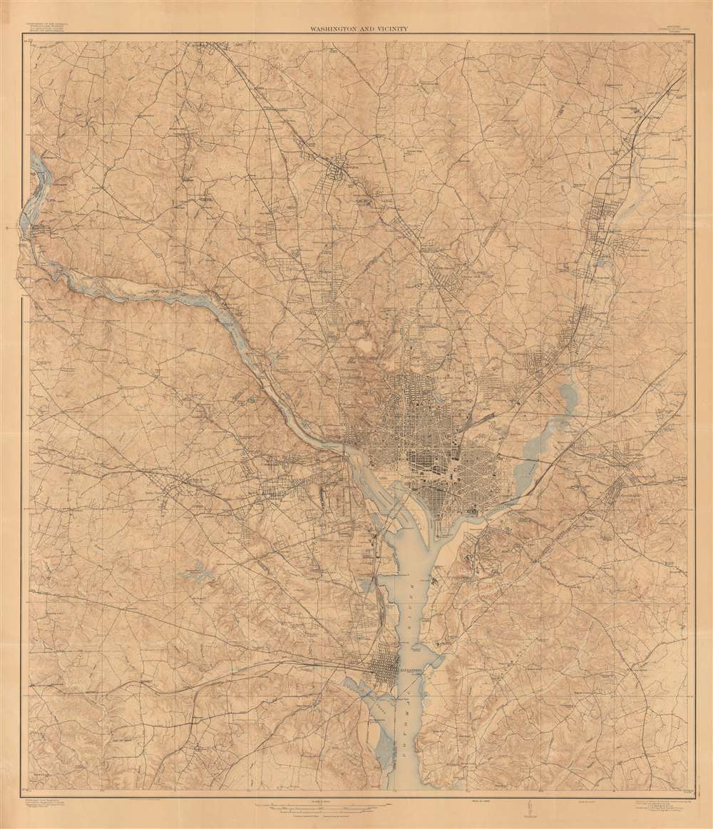
Washington and Vicinity.
1917 (dated) 51 x 44 in (129.54 x 111.76 cm) 1 : 31680
1917 (dated) 51 x 44 in (129.54 x 111.76 cm) 1 : 31680
Description
This is a large and intricately detailed 1917 U.S. Geological Survey map of Washington, D.C., and surrounding areas. It depicts the city in the midst of a rapid expansion in the early 20th century, when it benefitted from an increased focus on public services and the growing writ of the federal government, in part due to World War I.
At the start of the 20th century, Congressional attention was devoted to renovating the capital, embodied in the McMillan Plan, named for Senator James McMillan of Michigan who chaired a committee on the question. Charged with reconciling competing plans for rejuvenating the 'mediocre architecture and poor-quality public spaces,' among the commission's members were landscape architect Frederick Law Olmstead, the designer of Central Park in New York, architects Charles F. McKim and Daniel Burnham, and renowned sculptor Augustus Saint-Gaudens. The resulting plan called for an overhaul of the National Mall and several other projects, including parks, bridges, and museums. Although not all the Plan's recommendations were implemented, the city's face was remade, and many of its distinctive structures date to this era. Additionally, the first decade of the 20th century saw the opening of Union Station, one of the city's great landmarks, prominent to the north of the Capitol Building.
The Progressive agenda of Woodrow Wilson and the First World War also expanded the role of the federal government, requiring more office space and housing for the growing federal workforce (the U.S entered the war just a few months before this map's publication, but had been preparing for such a course for several months beforehand). The government and the city developed further with the New Deal policies of the 1930s and the Second World War. The growth of the city in the early 20th century can be seen by the surroundings of two of the city's universities, Georgetown and American. Here they are at the edge or even in the rural hinterland of the city, but by 1950 were well within an area of continuous urban development.
A Closer Look
The map highlights topography in particular, meticulously noting the hills surrounding the District to a distance of about 15 miles north of the National Mall and 10 miles to the south. Although no legend is included, major and minor roads, railroads, waterways, administrative boundaries, place names, and even individual homes and buildings are clearly indicated.Washington becomes a 'Real Capital'
This map was made when Washington, D.C. was in the process of transforming into its modern form as a sizable metro area inhabited by a growing army of bureaucrats and lobbyists. Prior to the late 19th century, the nation's capital had been fairly neglected. Although it had some monumental buildings and a sizable population, it lacked many basic services such as paved roads, and there was great uncertainty over whether the city's administration and funding should be controlled by Congress or local government.At the start of the 20th century, Congressional attention was devoted to renovating the capital, embodied in the McMillan Plan, named for Senator James McMillan of Michigan who chaired a committee on the question. Charged with reconciling competing plans for rejuvenating the 'mediocre architecture and poor-quality public spaces,' among the commission's members were landscape architect Frederick Law Olmstead, the designer of Central Park in New York, architects Charles F. McKim and Daniel Burnham, and renowned sculptor Augustus Saint-Gaudens. The resulting plan called for an overhaul of the National Mall and several other projects, including parks, bridges, and museums. Although not all the Plan's recommendations were implemented, the city's face was remade, and many of its distinctive structures date to this era. Additionally, the first decade of the 20th century saw the opening of Union Station, one of the city's great landmarks, prominent to the north of the Capitol Building.
The Progressive agenda of Woodrow Wilson and the First World War also expanded the role of the federal government, requiring more office space and housing for the growing federal workforce (the U.S entered the war just a few months before this map's publication, but had been preparing for such a course for several months beforehand). The government and the city developed further with the New Deal policies of the 1930s and the Second World War. The growth of the city in the early 20th century can be seen by the surroundings of two of the city's universities, Georgetown and American. Here they are at the edge or even in the rural hinterland of the city, but by 1950 were well within an area of continuous urban development.
Publication History and Census
This map was published by the U.S. Geological Survey in June 1917, based on its own surveys and those of the U.S. Coast and Geodetic Survey. It is held by a handful of institutions and universities in the United States and is scarce on the market.CartographerS
The United States Geological Survey (1878 - Present), aka the U.S.G.S., is a scientific agency of the United States government, which was founded in 1879. USGS scientists study the landscape of the United States, its natural resources, and the natural hazards that threaten it. The organization has four major science disciplines: biology, geography, geology, and hydrology. It is a bureau of the United States Department of the Interior and is the department's only scientific agency. More by this mapmaker...
The Office of the Coast Survey (1807 - present) founded in 1807 by President Thomas Jefferson and Secretary of Commerce Albert Gallatin, is the oldest scientific organization in the U.S. Federal Government. Jefferson created the "Survey of the Coast," as it was then called, in response to a need for accurate navigational charts of the new nation's coasts and harbors. The spirit of the Coast Survey was defined by its first two superintendents. The first superintendent of the Coast Survey was Swiss immigrant and West Point mathematics professor Ferdinand Hassler. Under the direction of Hassler, from 1816 to 1843, the ideological and scientific foundations for the Coast Survey were established. These included using the most advanced techniques and most sophisticated equipment as well as an unstinting attention to detail. Hassler devised a labor intensive triangulation system whereby the entire coast was divided into a series of enormous triangles. These were in turn subdivided into smaller triangulation units that were then individually surveyed. Employing this exacting technique on such a massive scale had never before been attempted. Consequently, Hassler and the Coast Survey under him developed a reputation for uncompromising dedication to the principles of accuracy and excellence. Unfortunately, despite being a masterful surveyor, Hassler was abrasive and politically unpopular, twice losing congressional funding for the Coast Survey. Nonetheless, Hassler led the Coast Survey until his death in 1843, at which time Alexander Dallas Bache, a great-grandson of Benjamin Franklin, took the helm. Bache was fully dedicated to the principles established by Hassler, but proved more politically astute and successfully lobbied Congress to liberally fund the endeavor. Under the leadership of A. D. Bache, the Coast Survey completed its most important work. Moreover, during his long tenure with the Coast Survey, from 1843 to 1865, Bache was a steadfast advocate of American science and navigation and in fact founded the American Academy of Sciences. Bache was succeeded by Benjamin Pierce who ran the Survey from 1867 to 1874. Pierce was in turn succeeded by Carlile Pollock Patterson who was Superintendent from 1874 to 1881. In 1878, under Patterson's superintendence, the U.S. Coast Survey was reorganized as the U.S. Coast and Geodetic Survey (C & GS) to accommodate topographic as well as nautical surveys. Today the Coast Survey is part of the National Oceanic and Atmospheric Administration or NOAA as the National Geodetic Survey. Learn More...
Condition
Good. Restoration and infill along multiple fold lines. Stabilized.
References
OCLC 1060682508.