This item has been sold, but you can get on the Waitlist to be notified if another example becomes available, or purchase a digital scan.
1864 U.S. Coast Survey Map of Washington D.C., Alexandria, and the Potomac River
WashingtonDCPotomac-uscs-1862$450.00

Title
Potomac River (in four sheets) Sheet No. 4.
1864 (dated) 40 x 23 in (101.6 x 58.42 cm)
1864 (dated) 40 x 23 in (101.6 x 58.42 cm)
Description
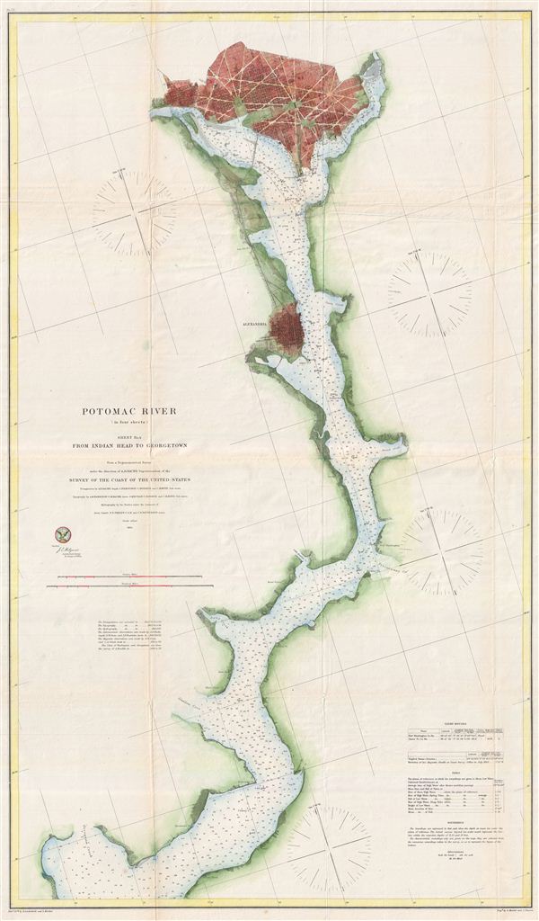
A rare and appealing three section map of Washington D.C., Alexandria, and the Potomac River issued by the U.S. Coast survey in 1864. The map covers the course of the Potomac River from Indian Point to Washington D.C. and includes both Alexandria and Georgetown.
Offers a fascinating snapshot of the nation's capital during the American Civil War. Shows the city in considerable detail with streets and important buildings noted. Identifies numerous important buildings including the Capitol, the Smithsonian Institution, the White House (not yet called the White House), the Washington Monument, the National Observatory, the Navel Yard, the Poor House, the City Hall, and others. The city's famous grid and ray structure appear according to L'enfant's brilliant plan. Georgetown appears as a separate entity in the upper left corner with Georgetown College noted just outside the city border.
This map further features countless depth soundings throughout and limited inland detail. The map notes various estuaries, creeks, and lesser rivers branching off the Potomac. The scale is 1:40,000. Technically this map is part of a four sheet series detailing the Potomac as far as the Chesapeake Bay, however, the other three charts are designed to join, while this is a standalone panel drawn on a different scale with a different orientation. The three charts detailing the southern portion of the Potomac River are currently being offered separately on this website. The triangulation for this chart was accomplished by A. D. Bache, C> Ferguson, C. Hosmer, and C. H. Boyd. The Topography is the work of A. M Harrison, C. B. Bache, J. Mechan, C. Hosmer and C. H. Boyd. The Hydrography was completed under the command of T.S. Phelps and C. P. Patterson. The whole was compiled under the exacting direction of A. D. Bache, Superintendent of the Coast Survey.
CartographerS
The Office of the Coast Survey (1807 - present) founded in 1807 by President Thomas Jefferson and Secretary of Commerce Albert Gallatin, is the oldest scientific organization in the U.S. Federal Government. Jefferson created the "Survey of the Coast," as it was then called, in response to a need for accurate navigational charts of the new nation's coasts and harbors. The spirit of the Coast Survey was defined by its first two superintendents. The first superintendent of the Coast Survey was Swiss immigrant and West Point mathematics professor Ferdinand Hassler. Under the direction of Hassler, from 1816 to 1843, the ideological and scientific foundations for the Coast Survey were established. These included using the most advanced techniques and most sophisticated equipment as well as an unstinting attention to detail. Hassler devised a labor intensive triangulation system whereby the entire coast was divided into a series of enormous triangles. These were in turn subdivided into smaller triangulation units that were then individually surveyed. Employing this exacting technique on such a massive scale had never before been attempted. Consequently, Hassler and the Coast Survey under him developed a reputation for uncompromising dedication to the principles of accuracy and excellence. Unfortunately, despite being a masterful surveyor, Hassler was abrasive and politically unpopular, twice losing congressional funding for the Coast Survey. Nonetheless, Hassler led the Coast Survey until his death in 1843, at which time Alexander Dallas Bache, a great-grandson of Benjamin Franklin, took the helm. Bache was fully dedicated to the principles established by Hassler, but proved more politically astute and successfully lobbied Congress to liberally fund the endeavor. Under the leadership of A. D. Bache, the Coast Survey completed its most important work. Moreover, during his long tenure with the Coast Survey, from 1843 to 1865, Bache was a steadfast advocate of American science and navigation and in fact founded the American Academy of Sciences. Bache was succeeded by Benjamin Pierce who ran the Survey from 1867 to 1874. Pierce was in turn succeeded by Carlile Pollock Patterson who was Superintendent from 1874 to 1881. In 1878, under Patterson's superintendence, the U.S. Coast Survey was reorganized as the U.S. Coast and Geodetic Survey (C & GS) to accommodate topographic as well as nautical surveys. Today the Coast Survey is part of the National Oceanic and Atmospheric Administration or NOAA as the National Geodetic Survey. More by this mapmaker...
Alexander Dallas Bache (July 19, 1806 - February 17, 1867) was an American physicist, scientist and surveyor. Bache is best known in cartographic circles as the Superintendent of the U.S. Coast Survey from 1843 to 1865. Born in Philadelphia, Bache, a great grandson of the statesman and inventor Benjamin Franklin, had a varied career primarily focused on education. He toured Europe on behalf of Girard College and composed an important treatise on European Education. Later he served as president of Philadelphia's Central High School and was a professor of natural history and chemistry at the University of Pennsylvania. On the death of Ferdinand Rudolph Hassler, Bache was appointed Superintendent of the United States Coast Survey. Picking up where Hassler left off Bache presided over the Survey during its most prolific period and oversaw the mapping of most of the United States coastline. To this day his name appears on countless marine pilot books and U.S. Coast Survey nautical charts. For his work he was elected Associate Fellow of the American Academy of Arts and Sciences, a Fellow of the Royal Society of Edinburgh, and a Foreign Member of the Royal Society. Following the Civil War, Bache was elected a 3rd Class Companion of the Military Order of the Loyal Legion of the United States. He died at Newport, Rhode Island and was buried in the Congressional Cemetery in Washington, DC, where he is commemorated with a monument built by American architect Henry Hobson Richardson. Learn More...
Source
Report of the Superintendent of the United States Coast Survey, Washington, 1864.
Condition
Very good condition. Some minor toning and verso reinforcement on original fold lines. Blank on verso.
References
LC Civil War Maps (2nd ed.), 53.4.