This item has been sold, but you can get on the Waitlist to be notified if another example becomes available, or purchase a digital scan.
1853 U.S. Coast Survey Map of the West Coast of the United States
WestCoast3-uscs-1853$250.00

Title
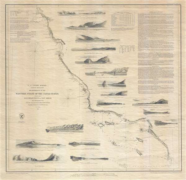
Reconnaissance of the Western Coast of the United States (Lower Sheet) San Francisco to San Diego.
1853 (dated) 23 x 23.5 in (58.42 x 59.69 cm) 1 : 1200000
1853 (dated) 23 x 23.5 in (58.42 x 59.69 cm) 1 : 1200000
Description
This is a separate issue example of the 1853 United States Coast Survey nautical chart or maritime map of the coast of California and it is one of the most attractive and desirable of the original U.S. Coast Survey charts of the region. The chart depicts the California coast from San Diego and the Mexican border north as far north as Pt. Reyes and San Francisco Bay. San Diego Bay, 'El Peublo de Los Angeles' and the Los Angeles Valley, the Mission of San Fernando and the San Fernando Valley, and the San Francisco Bay area including San Francisco itself, Oakland, San Jose, Union City and Alviso are all illustrated. By far the most dramatic quality of this piece is the inclusion of seventeen stunning coastal views, which are: 'View of the Entrance to San Francisco Bay,' 'View Pt. Piedras,' 'View Pt. Ano Nuevo,' 'View of Pt. Pinos,' 'View of Pt. Sur,' 'View of Piedras Blancas,' 'View of Moro Rock,' 'Esteros Bay,' 'View of Pt. Sal,' ' View Pt. Arguila,' 'View Pt. Concepcion bearing W. by S.,' 'View of Pt. Concepcion bearing S.E. by E.,' 'View Pt. Duma,' 'View of the Town and Mission of Santa Barbara,' 'View of San Pedro, Pt. Fermin,' 'View showing initial point of boundary between the United States and Mexico,' 'View of Catalina Harbor,' and a 'View Pt. Loma.' Numerous depth soundings are noted along the coastline and between major islands and undersea dangers. Copious notes and sailing instructions situated in the upper right hand corner are an interesting read for the nautically inclined:
To Enter San Francisco Bay There are no hidden dangers or anything to prevent the most timid navigator from entering the Harbor of San Francisco…It is noteworthy that this is an independent issue chart and was not prepared for inclusion in the superintendent's annual report. As such it is on thick stock and has no fold damage. The hydrographic work for this important chart was completed by James Alden and the geographical positioning was accomplished by G. Davidson. The whole was prepared and under the supervision of A. D. Bache, one of the most important and prolific figures in the early history of the U.S. Coast Survey
Vessels in sight of the coast and approaching San Diego from the North, will observe an opening in the hills, and the appearance of an inland bay. This is the False Port, and must be avoided…
CartographerS
Alexander Dallas Bache (July 19, 1806 - February 17, 1867) was an American physicist, scientist and surveyor. Bache is best known in cartographic circles as the Superintendent of the U.S. Coast Survey from 1843 to 1865. Born in Philadelphia, Bache, a great grandson of the statesman and inventor Benjamin Franklin, had a varied career primarily focused on education. He toured Europe on behalf of Girard College and composed an important treatise on European Education. Later he served as president of Philadelphia's Central High School and was a professor of natural history and chemistry at the University of Pennsylvania. On the death of Ferdinand Rudolph Hassler, Bache was appointed Superintendent of the United States Coast Survey. Picking up where Hassler left off Bache presided over the Survey during its most prolific period and oversaw the mapping of most of the United States coastline. To this day his name appears on countless marine pilot books and U.S. Coast Survey nautical charts. For his work he was elected Associate Fellow of the American Academy of Arts and Sciences, a Fellow of the Royal Society of Edinburgh, and a Foreign Member of the Royal Society. Following the Civil War, Bache was elected a 3rd Class Companion of the Military Order of the Loyal Legion of the United States. He died at Newport, Rhode Island and was buried in the Congressional Cemetery in Washington, DC, where he is commemorated with a monument built by American architect Henry Hobson Richardson. More by this mapmaker...
The Office of the Coast Survey (1807 - present) founded in 1807 by President Thomas Jefferson and Secretary of Commerce Albert Gallatin, is the oldest scientific organization in the U.S. Federal Government. Jefferson created the "Survey of the Coast," as it was then called, in response to a need for accurate navigational charts of the new nation's coasts and harbors. The spirit of the Coast Survey was defined by its first two superintendents. The first superintendent of the Coast Survey was Swiss immigrant and West Point mathematics professor Ferdinand Hassler. Under the direction of Hassler, from 1816 to 1843, the ideological and scientific foundations for the Coast Survey were established. These included using the most advanced techniques and most sophisticated equipment as well as an unstinting attention to detail. Hassler devised a labor intensive triangulation system whereby the entire coast was divided into a series of enormous triangles. These were in turn subdivided into smaller triangulation units that were then individually surveyed. Employing this exacting technique on such a massive scale had never before been attempted. Consequently, Hassler and the Coast Survey under him developed a reputation for uncompromising dedication to the principles of accuracy and excellence. Unfortunately, despite being a masterful surveyor, Hassler was abrasive and politically unpopular, twice losing congressional funding for the Coast Survey. Nonetheless, Hassler led the Coast Survey until his death in 1843, at which time Alexander Dallas Bache, a great-grandson of Benjamin Franklin, took the helm. Bache was fully dedicated to the principles established by Hassler, but proved more politically astute and successfully lobbied Congress to liberally fund the endeavor. Under the leadership of A. D. Bache, the Coast Survey completed its most important work. Moreover, during his long tenure with the Coast Survey, from 1843 to 1865, Bache was a steadfast advocate of American science and navigation and in fact founded the American Academy of Sciences. Bache was succeeded by Benjamin Pierce who ran the Survey from 1867 to 1874. Pierce was in turn succeeded by Carlile Pollock Patterson who was Superintendent from 1874 to 1881. In 1878, under Patterson's superintendence, the U.S. Coast Survey was reorganized as the U.S. Coast and Geodetic Survey (C & GS) to accommodate topographic as well as nautical surveys. Today the Coast Survey is part of the National Oceanic and Atmospheric Administration or NOAA as the National Geodetic Survey. Learn More...
Condition
Very good. Even overall toning. Blank on verso.
References
Rumsey 2470.046. Guthorn, P., United States Coastal Charts, 1783-1861, p. 200-201. Rowell, J.C., List of printed maps of California, p. 33. Vogdes, A. W., A Catalogue of the Official Geological Surveys in the State of California, p. 258. Heckrotte, W. & Sweetkind, J., California 49 : Forty-nine Maps of California from the sixteenth Century to the Present, map no. 33. Phillips (Atlases) 1269.