This item has been sold, but you can get on the Waitlist to be notified if another example becomes available, or purchase a digital scan.
1832 Royal Geographical Society Map of Western Australia
WesternAustralia-royalgeographical-1832$750.00

Title
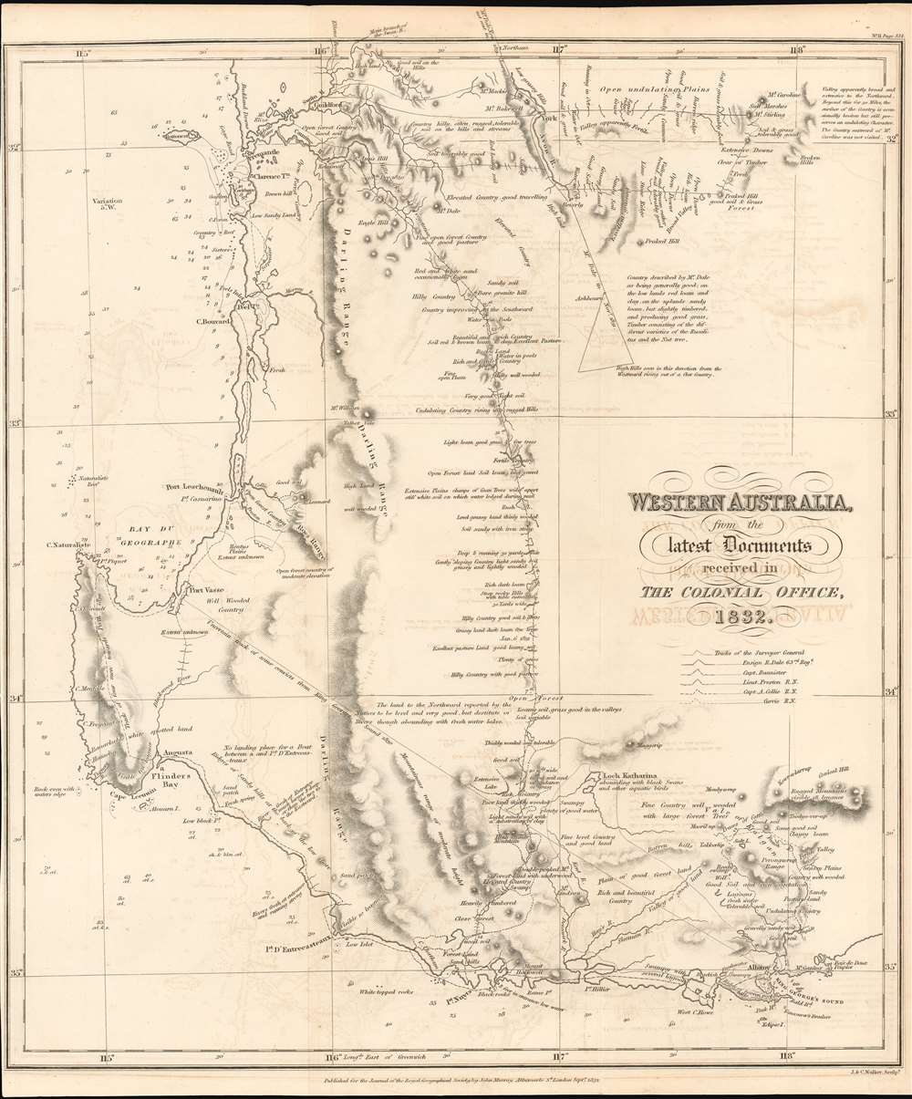
Western Australia from the Latest Documents received in The Colonial Office 1832.
1832 (dated) 15.25 x 13 in (38.735 x 33.02 cm) 1 : 1094400
1832 (dated) 15.25 x 13 in (38.735 x 33.02 cm) 1 : 1094400
Description
This 1832 Royal Geographical Society map of Western Australia is one of the earliest printed maps of the newly established Colony of Western Australia, hitherto known as the Swan River Colony. The map encompasses the area north of Perth and south coast beyond Albany. The mapping of the interior reveals the first European efforts to explore the region.
The Explorers
The map's key defines the tracks of six separate expeditions. These include that of the Surveyor General John Septimus Roe, who made the preliminary surveys for the Swan River Colony in 1829; Ensign R. Dale, whose explorations inland of Perth revealed promising agricultural and pastoral areas; Capt. Bannister, who surveyed the coast from Albany to Pt. Nuyts and explored inland there; Lt. Preston, who executed an overland survey from the Canning River to Pt. Nuyts, and a coastal expedition from there to Peel Town and Cape Bouvard. The tracks of Capt. Collie and Currie, show more involved explorations in the vicinity of Pt. Nuyts and Albany. All their tracks are well annotated with sightings, land formations, streams, and descriptions of the qualities of the land with regard to their fertility and suitability for colonization.Publication History and Census
OCLC lists only one example of the map in the National Library of Australia. We are aware of only a few that have come on the market in the past fifteen years.CartographerS
Royal Geographical Society (fl. 1830 - present) is a British Society established in 1830 to promote geographical science and exploration. Originally titled the "Geographical Society of London", the RGS received its royal charter from Queen Victoria in 1859 shortly after absorbing several similar but more regional societies including the African Association, the Raleigh Club and the Palestine Association. The RGS sponsored many of the most important and exciting voyages of exploration ever undertaken, including the exploration of Charles Darwin, David Livingstone, Robert Falcon Scott, Richard F. Burton, John Speke, George Hayward, H. M Stanley, Ernest Shackleton and Sir Edmond Hillary. Today, the RGS remains a leading global sponsor of geographical and scientific studies. The Society is based in Lowther Lodge, South Kensington, London. More by this mapmaker...
John Murray I (1737 - 1793) founded the British publishing firm John Murray (1768 - present) in London. Born in Edinburgh, Murray served as an officer in the Royal Marines and built a list of authors that included Isaac D’Israeli and published the English Review. Murray the elder also was one of the founding sponsors of the London evening newspaper The Star in 1788. John Murray II (November 27 1778 - June 27, 1843) continued the family publishing business and developed it into one of the most important and influential publishing houses in Britain. The list of authors published by the firm grew to include Jane Austen, Sir Walter Scott, Washington Irving, George Crabbe, and Lord Byron under his tenure. Murray II also moved the business to 50 Albermarle Street in Mayfair, which became famous for Murray’s tradition of ‘four o’clock friends’, which was afternoon tea with his writers. John Murray III (1808 - 1892) continued to grow the business, and the firm published the first English translation of Goethe’s Theory of Colours, David Livingstone’s Missionary Travels and Charles Darwin’s Origin of Species during his tenure. Murray also published Herman Melville’s first two books. The firm began publishing Murray Handbooks in 1836, an ancestor of all modern travel guides. Sir John Murray IV (1851 - 1928) was publisher to Queen Victoria. Three successive Murray’s after Murray IV led the business until it was purchased by Hodder Headline in 2002, which was acquired by the French conglomerate Lagardère Group in 2004. Today, Murray is an imprint of Lagardère under the imprint Hachette UK. Learn More...
John Walker (1787 - April 19, 1873) was a British map seller, engraver, lithographer, hydrographer, geographer, draughtsman, and publisher active in London during the 19th century. Walker published both nautical charts and geographical maps. His nautical work is particularly distinguished as he was an official hydrographer for the British East India Company, a position, incidentally, also held by his father of the same name. Walker's maps, mostly published after 1827, were primarily produced with his brothers Charles Walker and Alexander Walker under the imprint J. and C. Walker. Among their joint projects are more than 200 maps for the influential Society for the Diffusion of Useful Knowledge Atlas (SDUK). In addition they published numerous charts for James Horsburgh and the British Admiralty Hydrographic Office, including Belcher's important map of Hong Kong and Carless' exploratory map of Karachi. The J. and C. Walker firm continued to publish after both Walkers died in the 1870s. Learn More...
Source
Royal Geographical Society, 'Journal of the Royal Geographical Society' 1832 no. 2. (London, Walker)
Condition
Very good condition. Original fold lines. Faint offsetting. Left margin trimmed close but complete.
References
OCLC 222257740. Not recorded in Tooley.