
1918 Kenyon Map of Northern France / Western Front World War I

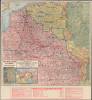
Kenyon's Map of the Western Battle Front.
The Last Weeks of the Great War
$250.00
Choose a Collection:
- Digital Map Information
- Suitable for large format printing
- Full resolution TIFF file
- ICC color profile embedded
- Delivered instantly via download link
This Item
Enquire
The Last Weeks of the Great War
This is a 1918 Kenyon Company map of the Western Front of the First World War. It reflects the situation in the weeks before the Armistice, after the German gains of the Spring (1918) Offensives had been erased, thanks primarily to the continuous arrival of new American units, shifting the balance of forces in favor of the Entente.A Detailed Look at the Battle Map
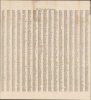
The map depicts the Western Front from the North Sea coast of Belgium to the Swiss border. As explained at bottom, a series of lines demonstrate the evolution of the conflict from 1914 until the time of publication, indicating that after four years of fighting and millions of lives lost, the frontline had not changed much. Numbers point out the locations of important battles and strategic points. The map is surrounded by a grid which corresponds to an index of towns on the verso.Insets depict the Eastern Front (under its own armistice at this time, confirmed by the Treaty of Brest-Litovsk) and the Italian Front, where the Germans and Austro-Hungarians had achieved a significant victory in the Battle of Caporetto in late 1917. However, as on the Western Front (see below), the Central Powers were undermanned and exhausted, leaving the door open to a counter-attack, which came in late October 1918 with the Battle of Vittorio Veneto. As was the case on the Western Front at the same time, the armies of the Central Powers suffered a wholesale collapse and an armistice (the Armistice of Villa Giusti) was signed on November 3, going into effect the following day.
World War I Grinds to a Halt
This map was published just weeks before the Armistice that ultimately would end the war. The main belligerents in the conflict were all exhausted, having suffered shocking numbers of casualties, economic depredation, and in some cases physical destruction of cities, towns, and much of the countryside. After several years of little movement on the Western Front, the final year and a half of the war saw sudden swings in momentum which left the result of the conflict in question. First, Russia experienced a revolution that was largely generated by the war and its economic impacts, resulting in an armistice and then a treaty to end the conflict on the Eastern Front. Then, troops of the American Expeditionary Force began to arrive on European battlefields in the summer of 1917, and by the end of the year were relieving badly depleted French and British units. In the spring of 1918, reinforced by units from the Eastern Front, the Germans launched a series of offensives that saw notable gains, even approaching their line of furthest advance in 1914. But with hundreds of thousands of U.S. troops arriving each month, the Entente powers were eventually able to halt the German advances. Though successful on paper, the German Spring Offensives had exhausted an already depleted force and failed to end the war. Instead, in August, the now-reinforced Entente troops counter-attacked and pushed the Germans back dozens of kilometers, erasing the gains of the Spring Offensives. The Germans hoped to make a stand at the imposing defenses of the Hindenburg Line, but by this point the country's exhausted troops had suffered a collapse in morale. In late September, the Entente attack on the Hindenburg Line commenced and by mid-October it was breached, forcing the Germans to retreat all the way back to German territory. By November 1, thanks to the infusion of American troops and German losses, the Germans were outnumbered nearly 3:1 on the Western Front. With their armies in nearly headlong flight and mutinies underway, the German wartime military government collapsed and a new civilian government sued for peace. By the time the Armistice went into effect on November 11, the Kaiser had been deposed and Germany declared a republic.Publication History and Census
This map was created by the Kenyon Company and published in 1918, most likely in late September or October, before the Armistice. The map was issued in several states in the closing months of the war (for a variation, see WesternFront-kenyon-1918 previously sold by us), but in any state it is only listed among the holdings of seven institutions in the OCLC.Cartographer
The Kenyon Company, Map Makers (fl. 1874 - c. 1930) was an American printing and publishing firm based in Des Moines, Iowa. The company published maps, atlases, and books, and advertised their high-grade calendars in the Des Moines Tribune. Further Details...
Condition
Very good. Wear along original fold lines. Verso repairs to fold separations. Location index on verso.