This item has been sold, but you can get on the Waitlist to be notified if another example becomes available, or purchase a digital scan.
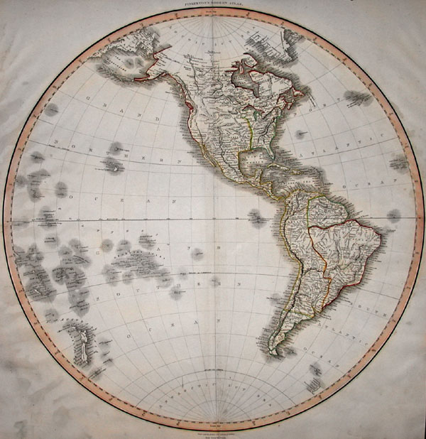
1817 Pinkerton Map of the Western Hemisphere ( North & South America )
WesternHemi-p-17$162.50

Title
Western Hemisphere.
1817 21 x 20 in (53.34 x 50.8 cm)
1817 21 x 20 in (53.34 x 50.8 cm)
Description
This hand colored map is a steel plate engraving, dating to 1814 by the important English mapmaker Pinkerton. It is a representation of the Americas, North and South, from the perspective of the Western Hemisphere. This map is extremely detailed and beautifully hand colored. When it was made, the United States extended no further west than the Mississippi River. The remainder of North America is shown divided between French, Spanish and English powers. Includes all of Polynesia, as well as the Azores. Pinkerton maps are known for their stunning color, awe inspiring size, and magnificent detail. Pinkerton's work, including this map, represents some of the finest cartographic art of the 19th century.
Cartographer
John Pinkerton (February 17, 1758 - March 10, 1826) was an Scottish writer, historian, and cartographer. Pinkerton was born in Edinburgh, Scotland. He was a studious youth with a passion for the classics. As a young man, he studied at Edinburgh University before apprenticing as a lawyer. Around this time, he began writing, with his first book, Elegy on Craigmillar Castle published in 1776. Pinkerton moved to London in 1781 to pursue his writing career in earnest. He successfully published several works of literature, poetry, and history. Pinkerton proved passionate in his literary and historical writings, but his correspondence with other cartographers has been labeled as aggressive, even insane. In addition to his work as a writer and historian, Pinkerton was one of the leading masters of the Edinburgh school of cartography which flourished from roughly 1800 to 1830. Pinkerton and his contemporaries (Thomson and Cary) redefined European cartography by abandoning typical 18th century decorative elements such as elaborate title cartouches and fantastical beasts in favor of detail and accuracy. Pinkerton's principle work is Pinkerton's Modern Atlas published from 1808 through 1815 with a special American reissue by Dobson and Co. in 1818. Pinkerton relocated to Paris in 1818, where he managed his publishing business until his death in 1826. More by this mapmaker...
Condition
Map is in good condition. Center fold will iron out beautifully for framing. Political boundaries as well as major states, territories, and counties are carefully labeled. All major cities, bodies of water, rivers, mountains, islands, and sub regions are also labeled and defined in vivid full color.