This item has been sold, but you can get on the Waitlist to be notified if another example becomes available, or purchase a digital scan.
1818 Pinkerton Map of the Western Hemisphere (North America, South America)
WesternHemisphere2-pinkerton-1818$300.00

Title
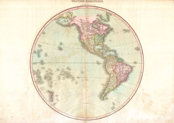
Western Hemisphere.
1818 (undated) 22 x 20 in (55.88 x 50.8 cm)
1818 (undated) 22 x 20 in (55.88 x 50.8 cm)
Description
A rare and important 1818 map of the Western Hemisphere by John Pinkerton. Depicts North America, Central America and South America as well as parts of Polynesia, Siberia and Greenland.
In North America, thanks primarily to the work of Cook in the Pacific Northwest the coasts are rendered with considerable accuracy. The interior of North America, particularly the American West, is still rather vague, though much of the cartography is clearly derived from Humboldt's explorations. Notes the conjectural Lake Timpanagos, often associated with indigenous reports of the Great Salt Lake. The United States, still quite small, does not yet include Florida, Louisiana, California or Texas.
South America exhibits its typical clear outline and speculative interior. Pinkerton resurrects the idea of Lake Parima in Guyana - supposed site of El Dorado - which had all but disappeared from most other early 19th century maps. On the other hand, Pinkerton has dropped the Apocryphal Laguna de Xarayes, commonly located at the northern extremis of the Paraguay or Parma River. However, he does note several supposed gold mines deep in the Amazon, which may or may not reflect indigenous legends of El Dorado.
Drawn by L. Herbert and engraved by Samuel Neele under the direction of John Pinkerton. The map comes from the scarce American edition of Pinkerton's Modern Atlas, published by Thomas Dobson & Co. of Philadelphia in 1818.
CartographerS
John Pinkerton (February 17, 1758 - March 10, 1826) was an Scottish writer, historian, and cartographer. Pinkerton was born in Edinburgh, Scotland. He was a studious youth with a passion for the classics. As a young man, he studied at Edinburgh University before apprenticing as a lawyer. Around this time, he began writing, with his first book, Elegy on Craigmillar Castle published in 1776. Pinkerton moved to London in 1781 to pursue his writing career in earnest. He successfully published several works of literature, poetry, and history. Pinkerton proved passionate in his literary and historical writings, but his correspondence with other cartographers has been labeled as aggressive, even insane. In addition to his work as a writer and historian, Pinkerton was one of the leading masters of the Edinburgh school of cartography which flourished from roughly 1800 to 1830. Pinkerton and his contemporaries (Thomson and Cary) redefined European cartography by abandoning typical 18th century decorative elements such as elaborate title cartouches and fantastical beasts in favor of detail and accuracy. Pinkerton's principle work is Pinkerton's Modern Atlas published from 1808 through 1815 with a special American reissue by Dobson and Co. in 1818. Pinkerton relocated to Paris in 1818, where he managed his publishing business until his death in 1826. More by this mapmaker...
Thomas Dobson (1751 - 1823) was an American publisher active in Philadelphia during the late 18th and early 19th centuries. Dobson was born in Edinburgh, Scotland in 1751 and emigrated to Philadelphia c. 1780. In Philadelphia, he established a successful printing business by republishing edited and updated versions of important British reference materials in matching quality but at a much lower price point. He is best known for publishing the first American edition of the Encyclopedia Britannica. He also published America's first Hebrew Bible. Cartographically Dobson's most notable work is 1818 republication of Pinkerton's fantastic Modern Atlas. Learn More...
Source
Pinkerton, J., A Modern Atlas, from the Lates and Best Authorities, Exhibiting the Various Divisions of the World with its chief Empires, Kingdoms, and States; in Sixty Maps, carefully reduced from the Larges and Most Authentic Sources. 1818, Philadelphia, Thomas Dobson Edition.
Condition
Very good condition. Minor discoloration along original centerfold. Minor dampstaining in lower margins. Blank on verso.
References
Rumsey 0732.001. Phillips (Atlases) 724. National Maritime Museum, 409.