This item has been sold, but you can get on the Waitlist to be notified if another example becomes available, or purchase a digital scan.
1804 Joseph Ellicott Map of New York State West of the Geneseo
WesternNewYork-ellicott-1804$2,750.00

Title
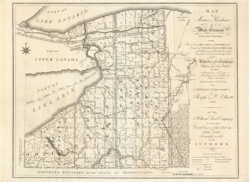
Map of Morris's Purchase or West Geneseo In the State of New York.
1804 (dated) 20.3 x 26.25 in (51.562 x 66.675 cm) 1 : 336000
1804 (dated) 20.3 x 26.25 in (51.562 x 66.675 cm) 1 : 336000
Description
This is Joseph Ellicott's rare map of New York State west of the Genesee River, in a magnificent example. It is a remarkable cartographic achievement. Rumsey admiringly notes:
The map is highly detailed, showing every tributary of every tributary of every stream. All the township and range lines are laid down, every town located, all reservations shown and all roads indicated. One has the impression that the ground was expertly surveyed with care and diligence.Vail hails the map as the 'Most important map of the Holland Land Company, published for the promotion of sale of their Western New York lands.' Nestler praises it as 'the most important map of western NY when Buffalo was still known as New Amsterdam, and when land companies were luring settlers to this new frontier.'
The Holland Land Company
The map shows three and a half million acres of land purchased between 1792 and 1797 from the American banker, Robert Morris, by a group of Dutch bankers. This, combined with an additional 1.4 million acres of Northwestern Pennsylvania from James Wilson, was dubbed 'The Holland Purchase' and the contortium of bankers 'The Holland Land Company.' Joseph Ellicott, having established himself as a surveyor working with his elder brother on the initial survey of Washington DC, was hired in 1797 by the Company to survey the Purchase. After living the next two years in the open executing the monumental survey, he would become agent for the company, administering the sale of the lands around the company's offices in Batavia.The Ownership of the Land
The presence of reservations, 'Indian Paths' and 'Indian Villages' throughout the map show the traces of the original inhabitants of the land here mapped. Sovereignty over the land was granted to New York in the 1786 Treaty of Hartford, though title to the land had been granted to Massachusetts; Robert Morris - financier and signer of the Declaration of Independence - purchased the land from the Commonwealth in 1791, before selling it along to the Holland Land Company.A Glimpse Of the Pre-Computer Map Trade
Accompanying this map is a three-page, unsigned manuscript introduction and historical gloss of the map. It is unsigned, but is clearly written from the mapseller to the purchaser of the map. In addition to a description of the Holland Land Company and Ellicott's work, the writer addresses the care of the map:Would suggest not marking 'X' where your place is located and instead reasonably preserving this nearly 200 year old rag paper original... Mr. Glen (sic) Cantrell of Erie Book Store is an experienced collector of old maps and his daughter Kathy Cantrell, current owner of the store, would be pleased, I am sure, to advise you on how to keep it reasonably well preserved or protectively matted and framed, if you so desire. Even unroll and roll carefully and let no one try to clean it, unless they are experienced experts.
Publication History and Census
An edition appears to have been printed in 1800, either in Albany or in Amsterdam, but this appears to be of the utmost rarity, having been supplanted by this 1804 issue. This latter map is itself quite rare, being separately issued. We see examples in twenty-two institutional collections.Cartographer
Joseph Ellicott (November 1, 1760 - August 19, 1826) was an American surveyor, city planner, land office agent, lawyer and politician. He is known for having produced the city plans of Batavia and Buffalo in New York State, and produced the first detailed map of New York State west of the Genesee River. He was born in Bucks County, Pennsylvania to Quaker parents, along with his older brother Andrew, (who surveyed the future grounds of Washington, D. C.) and his younger sibling Benjamin, who would become a U.S. Congressman. His education is not known, but he was his brother Andrew's chief assistant during the latter part of the Washington D.C. survey. He later traveled to Georgia to survey the newly established boundary with the Creek tribe. In 1797 he was hired by the Holland Land Company to survey the huge tract of western New York (later known as The Holland Purchase.) He spent the next two years living outdoors undertaking the survey, which he finally completed in October 1800. He would become the company's agent in Batavia, New York, whose city plan he executed in 1801. He did the same in 1804 for the village of Buffalo. He was an early advocate for the creation of the Erie Canal, and was among the Commissioners appointed in 1816 to supervise the canal construction. More by this mapmaker...
Condition
Excellent condition: a superb, virtually unblemished example with no repairs.
References
Rumsey 3712. OCLC 52510562. Streeter 892; Rumsey 3712; Nestler, H., A Bibliography of New York State Communities, Counties, Towns, Villagesp.109; Vail 1223; Dict. of Amer. Biog. vol. 6, pp. 90-91.