This item has been sold, but you can get on the Waitlist to be notified if another example becomes available, or purchase a digital scan.
1853 Atwood Map of Ohio, Michigan, Illinois, Indiana, Wisconsin, Iowa, Missouri, and Minnesota
WesternStates-atwood-1853$300.00

Title
Map of the Western States.
1853 (dated) 22 x 28 in (55.88 x 71.12 cm)
1853 (dated) 22 x 28 in (55.88 x 71.12 cm)
Description
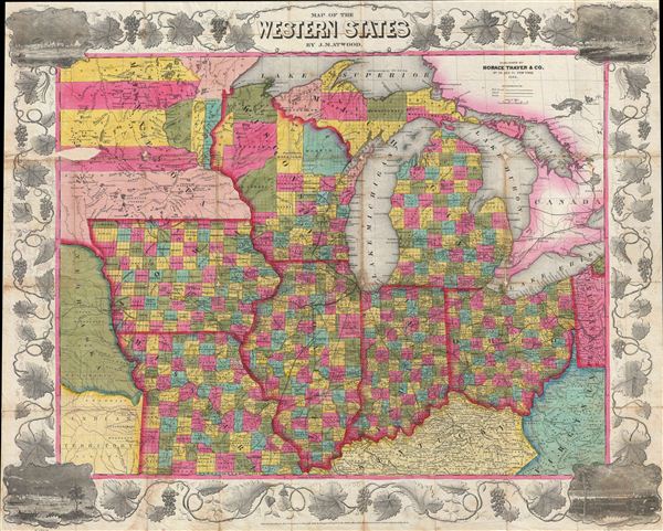
An attractive example of Thayer's 1853 map of the Western States. Centered on Lake Michigan, Thayer's map covers the states of Ohio, Michigan, Indiana, Illinois, Wisconsin, Iowa, and Missouri, with portions of adjacent Minnesota, Kentucky, Virginia, Pennsylvania, Nebraska, and the Indian Territory. The Great Lakes are well represented with Lake Michigan, Lake Huron, and Lake erie appearing in full, while Lake Ontario and Lake Superior are depicted only partially. excellent detail is offered throughout with counties being identified by color coding and roads, towns, rail lines, and canals noted. The map is surrounded by an appealing grape vine border with corner vignettes illustrating, clockwise from top left, Chicago, Detroit, Cincinnati, and St. Louis.
Traveler's guides, like this map, became indispensable tools in the American Westward expansion. Such maps, and their accompanying guides, were designed to help new immigrants find their way to the free lands in the west. Though by the time this map was issued, the population boost following the 1849 Gold Rush had turned California into a state, most of the lands in-between were little known, sparkly populated, and dominated great buffalo herds, and American Indian Nations - many of which are noted here in the lads to the west of the Missouri River. In the meantime the Missouri Compromise and associated border conflicts in this region were increasingly dividing the country over the issues of Slavery and Federal vs. State sovereignty.
This map first appeared in 1848 to accompany ensign and Thayer's Traveler's Guide, and was updated regularly through the 1850s. Accompanied by original leather bound guidebook and binder.
CartographerS
John M. Atwood (1817 - October 12, 1884) was an American engraver based in Philadelphia and New York City during the middle part of the 19th century. Atwood was born in Georgetown, near Washington D.C. Little is known of Atwood's life but most of his work was completed in conjunction with the publishing firms of Horace Thayer and J. H. Colton. A review of Atwood's work suggests that he was a highly accomplished, stylistically distinct, and detail oriented engraver. Colton seems to have turned to Atwood to engrave some of his most important as well as decorative maps. His most influential map is most likely the 1856 De Cordova pocket map of Texas, however, he also engraved the Colton's well known and highly decorative Thirty Three Miles Around New York and Colton's important 1849 Map of the United States. More by this mapmaker...
Horace Thayer (June 29, 1811 - March 15, 1875) was a New York based publisher and lithographer active in New York City and Buffalo, New York, during the middle part of the 19th century. Thayer's publications focused on travel guides, wall, and pocket maps - many of which were based on the works of other American cartographers including J. H. Colton and S. A. Mitchell. In the 1840s, he partnered with the Hartford, Connecticut publisher Timothy Ensign (1795 - 1849) and later his son, Edward Hooker Ensign (1818 - 1871). According to map historian Walter Ristow, J. H. Colton's older son, George Washington Colton, partnered with Thayer in the late 1850s and early 1860s, possibly in order to learn Thayer's lithography techniques. Certainly a number of maps emerged bearing a 'Thayer and Colton' imprint. At various points Thayer also published with other prominent publishers and printmakers, publishing as Kelloggs and Thayer (1846 - 1847), Ensigns and Thayer (1848), Ensign and Thayer (1849 - 1850), and Ensign, Thayer, and Company (1850 - 1851), Phelps and Watson (1859), and Thayer and Colton (1859-186?). Thayer seems to have moved frequently and had offices at 50 Ann Street, 156 William Street, and at 18 Beekman Street, all in New York City. Learn More...
Source
Thayer, H., Ensign and Thayer's Map of the Western States, (New York) 1853.
Condition
Good condition. Map in generally in excellent condition, however, it does suffer from typical wear along the original fold lines. This map further suffers from a small area of loss in western Minnesota - see image. The map has been flattened and backed with archival Japanese tissue for stability.
References
Howes, W., U.S.iana (1650-1950): A Selective Bibliography in which are Described 11,620 Uncommon and Siginficant Books Relating to the Continental Portion of the United States, E165.