This item has been sold, but you can get on the Waitlist to be notified if another example becomes available, or purchase a digital scan.
1834 Hood Map of the Indian Lands in Okalahoma, Kansas, and Nebraska
WesternTerritory-hood-1834$500.00

Title
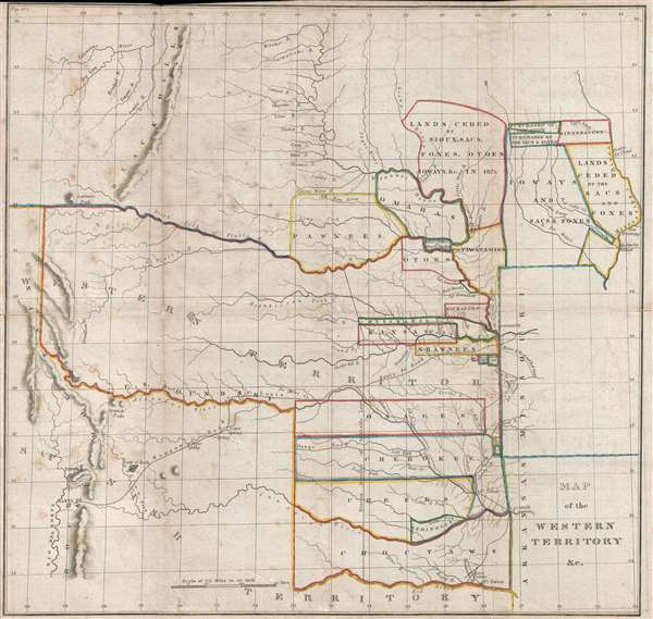
Map of the Western Territory and c.
1934 (undated) 17.5 x 18.25 in (44.45 x 46.355 cm) 1 : 3620600
1934 (undated) 17.5 x 18.25 in (44.45 x 46.355 cm) 1 : 3620600
Description
A trans-Mississippi map of considerable interest and historical importance, this is Washington Hood's 1834 map of American Indian lands in modern day Oklahoma, Kansas, Nebraska, and Iowa (although coverage extends to Colorado, Wyoming, New Mexico, and parts of Texas). In Oklahoma, these are the lands ceded to various tribes following the Indian Removal Act of 1830 which lead to the Trail of Tears. Hood also identifies lands in modern day Iowa and Kansas ceded or sold by the Ioway, Sacs and Foxes, Sioux, Winnebagoe, and other tribes between 1820 and 1830.
Cartographically the map has much merit. According to Wheat, Hood's map
The intention of Hood's map was to accompany three congressional bills associated with the Department of Indian Affairs indented to regulate the ceded lands. These were
This map was issued in Everett 1834 House of Representatives Congressional Report, no. 474, Regulating the Indian Department. It was printed by Gales and Seaton in Washington D.C. This is the first published map prepared by Hood, who would go on to produce several other highly influential government maps.
Cartographically the map has much merit. According to Wheat, Hood's map
was a high credible performance. It not only showed the various Indian land assignment by tribes west of the Arkansas and Missouri, following McCoy, but its maker used Brown's Santa Fe trail material, and delineated the country to the front wall of the Rockies and Santa Fe with considerable accuracy.This map followed the Indian Removal Act of 1830, wherein the 'Five Civilized Tribes' (Cherokee, Chickasaw, Choctaw, Creek and Seminole) were removed from their traditional lands in the American Southeast to newly assigned lands, as seen here, in what is now Oklahoma and Nebraska – a migration now generally known as the Trail of Tears. At the time of issue, the mass American Indian migrations, which lasted until 1839, were in their early stages and many tribes had not yet fully relocated to their assigned lands.
The intention of Hood's map was to accompany three congressional bills associated with the Department of Indian Affairs indented to regulate the ceded lands. These were
- A bill to provide for the organization of the department of Indian Affairs
- A bill to regulate trade and intercourse with the Indian tribes, and to preserve peace on the frontiers
- A bill to provide for the establishment of the Western Territory, and for the security and protection of the emigrant and other Indian Tribes therein.
This map was issued in Everett 1834 House of Representatives Congressional Report, no. 474, Regulating the Indian Department. It was printed by Gales and Seaton in Washington D.C. This is the first published map prepared by Hood, who would go on to produce several other highly influential government maps.
Cartographer
Washington Hood (February 2, 1808 – July 17, 1840) was American army officer in the Corps of Topographical Engineers. Hood was born in Philadelphia, Pennsylvania, the son of John McClellan Hood, a wholesale grocer. Hood attended West Point, from which he was the 500th graduate, matriculating with in the class of 1827. Between 1831 and 1846 he completed various topographical surveys in Missouri and Florida (Seminole Wars?). He next worked with Robert E. Lee measuring the Ohio-Michigan line. In 1836, Hood resigned his military commission to work as a private civil engineer. He spent much of 1837 in Cuba, where he performed railroad work. He rejoined the military as a Captain in 1838 and in that year produced his landmark map of Oregon territory. In 1839, President Van Buren sent him to survey the Oklahoma Shawnee lands between the Arkansas and Missouri River. During this assignment, he contracted an unknown illness from which he died less than a year later. A large archive of his important sketches and manuscripts are preserved at the Winterthur Library in Delaware and Beinecke Rare Book Library, at Yale. More by this mapmaker...
Source
Everett, H., 'Regulating the Indian Department,' Rep. No. 474, (Washington: Gales and Seaton) 1834.
Condition
Good. A few minor verso reinforcemtns. Top margin narrow as issued.
References
Wheat, C. I., Mapping of the Transmississippi West, 1540 – 1861, 405. OCLC 298988770. Howes, W., U.S.iana (1650-1950): A Selective Bibliography in which are Described 11,620 Uncommon and Significant Books Relating to the Continental Portion of the United States, E-235.