This item has been sold, but you can get on the Waitlist to be notified if another example becomes available, or purchase a digital scan.
1861 Berghaus Map of the West Indies and Central America
WestIndien-berghaus-1861$225.00

Title
West-Indien und Central-Amerika.
1861 (dated) 14 x 17 in (35.56 x 43.18 cm) 1 : 9250000
1861 (dated) 14 x 17 in (35.56 x 43.18 cm) 1 : 9250000
Description
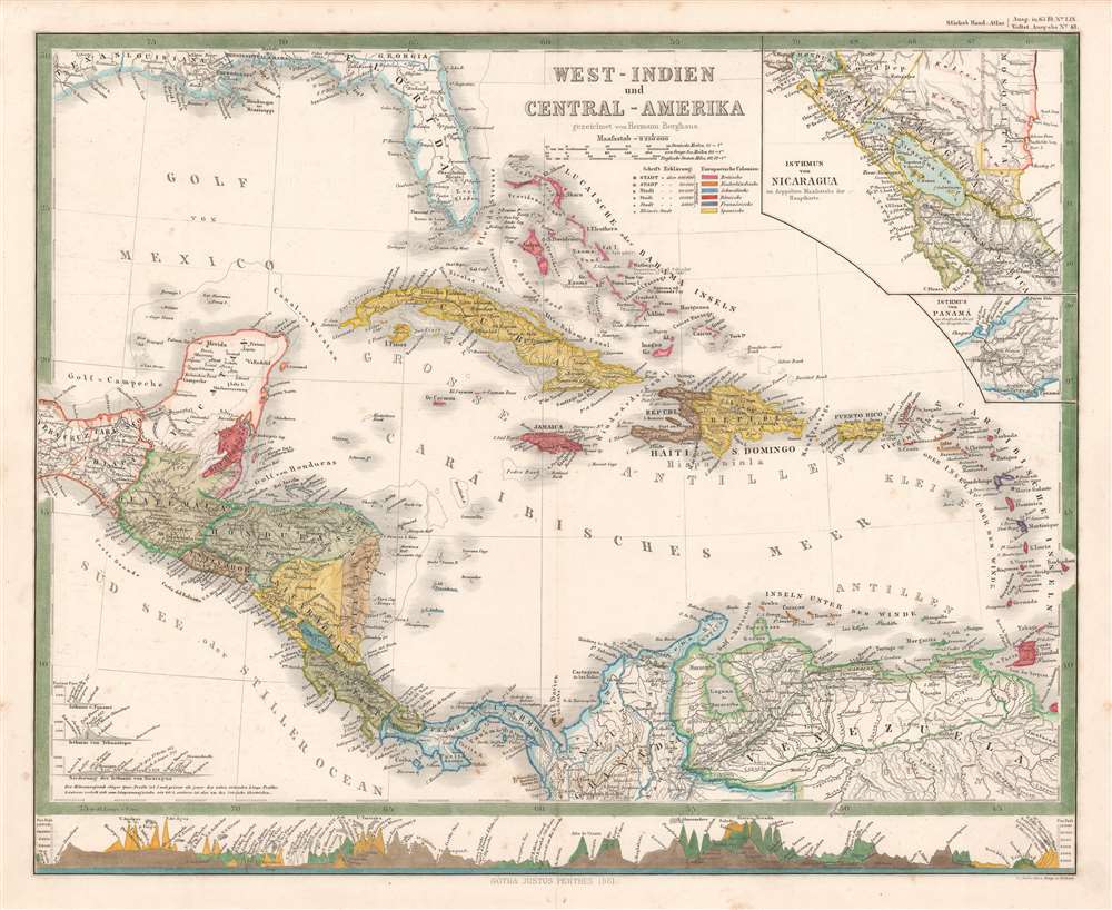
A striking 1861 Hermann Berghaus map of the West Indies and Central America. The map depicts the region from the Tehuantepec Isthmus in Mexico to the Leeward Islands and from the Gulf Coast of the United States to northern South America. Published near the height of the mid-19th century European race for colonial acquisition, six different colors are used to highlight British, French, Dutch, Spanish, Danish, and Swedish colonies. The only Swedish colony in the Caribbean at the time was Saint Barthelemy, a small island near Anguilla, Saint Martin, and Barbuda, although it is not correctly colored. An inset map in the upper right corner details the Isthmus of Nicaragua, highlighting the roads throughout the region, particularly along the Pacific coast. An inset of the Isthmus of Panama is included just below the one of Nicaragua and presents in detail the rail line constructed across the isthmus from Colon to Panama City, one of the preferred ways to transfer goods from the Atlantic to the Pacific before the construction of the Panama Canal. There are profile illustrations of the Isthmuses of Panama, Nicaragua, and Tehuantepec in southern Mexico, all three of which were used to transfer goods across Central America, and all three of which were being promoted as potential options for an inter-oceanic canal.
Publication History
This map was created by Hermann Berghaus and published by Justus Perthes as part of the 1861 edition of Adolf Steiler's Handatlas.CartographerS
Hermann Berghaus (November 16, 1828 - December 3, 1890) was a German cartographer active in Gotha, Germany, in the second half of the 19th century. Berghaus was born in Herford, Westphalia, the son of a pastor. His received his primary education as schools in Herford and Halle, where he discovered a talent for drawing. From 1842 to 1845 he studied cartography and art under his uncle, the Postdam educator, geographer, and surveyor Heinrich Karl Wilhelm Berghaus (1797 - 1884). Shortly after 1845 Berghaus was recruited by Wilhelm Perthes, son of Justus Perthes, to work at the Geographical Institute of Justus Perthes at Gotha (Justus Perthes' Geographische Anstalt Gotha). His work there included his most noteworthy project, a densely detailed and impressive large format folding chart of the world first published in 1863 and updated in at least 14 editions to about 1909. Other than his great work map, Berghaus' work was primarily dedicated to updating obsolete versions of earlier Perthes map publications. The exacting work caused him to lose his eyesight, a common problem for cartographers and engravers, in 1888. His work earned him an Honorary Doctorate of Philosophy at the University of Königsberg (1868), a gold medal at the Congress of Cartographers in Venice (1881), and an appointment to the German Academy of Sciences Leopoldina (1883). More by this mapmaker...
Johan Georg Justus Perthes (September 11, 1749 - May 2, 1816) was one of the most important German cartographic engravers of the 19th century. He was born in the Thuringian town of Rudolstadt, the son of a court physician. In 1778, he began working as a bookseller in Gotha. Perthes began his publishing empire shortly thereafter with the 1784 issue of the famed survey of European nobility known as the Almanac de Gotha. In the next year, 1785, he founded the cartographic firm of Justus Perthes Geographische Anstalt Gotha. His son Wilhelm Perthes (1793 - 1853) joined the firm in 1814. Wilhelm had prior publishing experience at the firm of Justus Perthes' nephew, Friedrich Christoph Perthes, who ran a publishing house in Hamburg. After Justus Perthes died in 1816, Wilhelm took charge and laid the groundwork for the firm to become a cartographic publishing titan. From 1817 to 1890. the Perthes firm issued thousands of maps and more than 20 different atlases. Along with the visionary editors Hermann Berghaus (1797 - 1884), Adolph Stieler (1775 - 1836), and Karl Spruner (1803 - 1892), the Perthes firm pioneered the Hand Atlas. When Wilhelm retired, management of the firm passed to his son, Bernhardt Wilhelm Perthes (1821 – 1857). Bernhardt brought on the cartographic geniuses August Heinrich Peterman (1822 - 1878) and Bruno Hassenstein (1839 - 1902). The firm was subsequently passed to a fourth generation in the form of Berhanrd Perthes (1858 – 1919), Bernhard Wilhelm's son. The firm continued in the family until 1953 when, being in East Germany, it was nationalized and run as a state-owned enterprise as VEB Hermann Haack Geographisch-Kartographische Anstalt Gotha. The Justus family, led by Joachim Justus Perthes and his son Wolf-Jürgen Perthes, relocated to Darmstadt where they founded the Justus Perthes Geographische Verlagsanstalt Darmstadt. Learn More...
Adolf Stieler (1775 – 1836) was a German cartographer who worked most of his life in the Justus Perthes Geographical Institute in Gotha. His atlases are deservedly held in high esteem for their excellence. His Handatlas was the leading German world atlas until the middle of the 20th century, parts of which were printed until 1944. Learn More...
Condition
Very good. Even overall toning. Light soiling. Verso repair to centerfold separation. Blank on verso.