This item has been sold, but you can get on the Waitlist to be notified if another example becomes available, or purchase a digital scan.
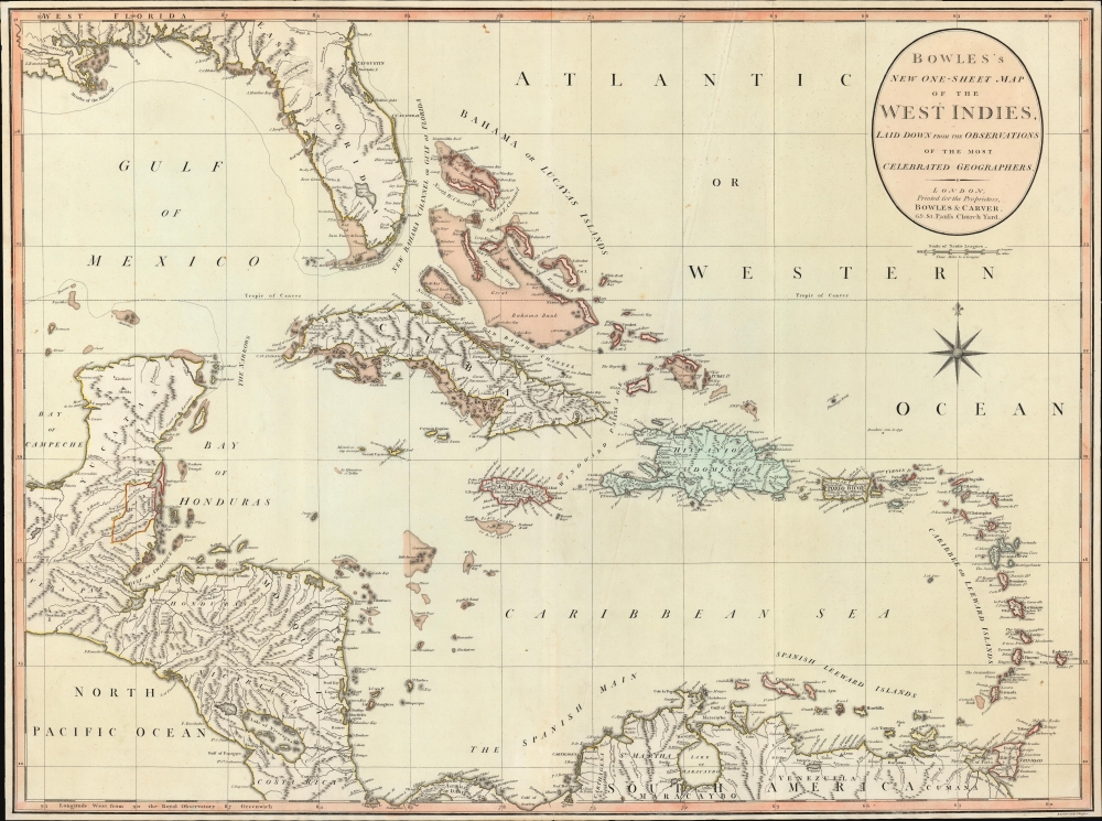
1798 Bowles and Carver Map of the West Indies and Florida
WestIndies-bowlescarver-1798$1,750.00

Title
Bowles's New One-Sheet Map of the West Indies, Laid Down from the Observations of Celebrated Geographers.
1798 (undated) 20.75 x 28 in (52.705 x 71.12 cm) 1 : 4752000
1798 (undated) 20.75 x 28 in (52.705 x 71.12 cm) 1 : 4752000
Description
An exceptional example of Bowles and Carver's c. 1798 map of the West Indies - this is one of the first maps to recognize formal British claims over Belize (British Honduras).
Lake Okeechobee and several feeder rivers are ghosted in and tentatively labeled 'Supposed Lake of Mujaco'. 'Mujaco' is somewhat unusual, appearing only on 2 or 3 maps. The term is a deviation of the more common 'Mayaco', after the Maraca people of Florida who came from the upper area of the St. Johns River and migrated to the Lake Okeechobee region in the early 18th century.
A Closer Look
Coverage embraces the West Indies and Caribbean, as well as Florida, the Yucatan, and parts of Central America, including Honduras, Guatemala, British Honduras (Belize), Nicaragua, and the Mosquita. Shading indicates reefs and low waters - especially notable in the Bahamas. Florida features little inland detail, although St. Augustine, Fort St. George, and Pensacola are noted along the coasts. Tampa Bay is identified as 'Spiritu Santo' with adjacent 'Hillsboro Bay'. Color coding throughout the islands underscores competing colonial empires, particularly French (blue), Spanish (yellow), and British (red) claims.Lake Okeechobee and several feeder rivers are ghosted in and tentatively labeled 'Supposed Lake of Mujaco'. 'Mujaco' is somewhat unusual, appearing only on 2 or 3 maps. The term is a deviation of the more common 'Mayaco', after the Maraca people of Florida who came from the upper area of the St. Johns River and migrated to the Lake Okeechobee region in the early 18th century.
Belize or British Honduras
In the 1790s, British Honduras, now known as Belize, was evolving from a British logging settlement into a formally recognized colony. This decade was characterized by increasing tensions and skirmishes with Spanish forces, as Spain formally controlled the territory based on treaties, yet lacked the permanent presence to enforce its claims. The British, primarily interested in exploiting the valuable mahogany and logwood forests, established a more permanent settlement structure despite the Spanish threat. The pivotal event of this era occurred in 1798, with the Battle of St. George's Caye, where British settlers and their African enslaved workers decisively defeated a Spanish fleet, leading to a significant decrease in Spanish attempts to reclaim the area. This victory not only secured British control over the territory but also laid the groundwork for the development of a distinct Belizean identity and eventual path towards independence.Publication History and Census
This map was issued by Henry Carrington Bowles and Jonathan Carver in London, c. 1798. It was engraved in Islington, London, by Benjamin Baker. We note at least two editions, one undated, as here, with British claims in Belize (British Honduras) mapped, and another without British Honduras dated 1798. We believe this to be an updated edition, published later in 1798, reflecting the outcome of the Battle of St. George's Caye (1798) and the gradual formalization of British claims in Belize. We note comparable examples at the Florida State Library and at the Bayerische Staatsbibliothek (both misdated 1783). Very little market history.CartographerS
The Bowles Family (fl. c. 1714 - 1832) were publishers and map sellers active in London from c. 1714 to c. 1832. The firm, under Thomas Bowles (fl. 1714 - 1763), John Bowles (1701 - 1779), Carrington Bowles (1724 - 1793), and as Bowles and Carver (fl. 1794 - 1832), produced a massive corpus of work that included numerous atlases, pocket maps, and wall maps. The Bowles publishing tradition was kept alive for four generations, starting with Thomas Bowles, a print engraver active in the late 17th century. His son, Thomas Bowles II, produced the firm's first maps at St. Paul's Churchyard, London. Thomas's brother, John Bowles (a.k.a. 'Old John Bowles' or 'Black Horse Bowles'), was also an active publisher established at no. 13 Cornhill. He is credited as one of the first publishers of William Hogarth's works. There, John's son, Carrington Bowles, was introduced to the trade. Carrington took over the Cornhill bookshop and eventually merged it with his uncle's shop in St. Paul's Churchyard. On Carrington's 1793 death, the business was passed to his son Henry Carrington Bowles (1763 - 1830), who partnered with his father's former apprentice Samuel Carver (1756 - 1841), renaming the firm 'Bowles and Carver'. Under this imprint, the firm continued to publish maps and atlases until 1832. Henry Carrington Bowles died in 1830, but Samuel Carver, himself in advanced years and poor health, kept it going for another 2 years before closing the business. More by this mapmaker...
Benjamin Baker (1766 - June 29, 1841) was British engraver active in the late 18th and early 19th centuries. Baker was born in London, the son of instrument maker Edward Baker (1730 - 1797). As a young map he was apprenticed to Thomas Beresford, a watchmaker. This likely did not work out, as he was turned over to the engraver, mapmaker, and globemaker William Palmer (1739 - 1812). Baker rose to prominence as an engraver for the British Admiralty and British Ordnance Survey. In time he became the principal engraver for the Ordnance Survey, not only engraving himself, but overseeing the entire team of Ordnance engravers. His son, Benjamin Richard Baker (1792 - 1876) was also a mapmaker, engraver, draughtsman, lithographer, and printer. Learn More...
Condition
Very good. Traces of old fold extending from top right towards center. Slight spotting here and there.
References
OCLC 44441158.