1863 Copley Blueback Chart of the West Indies
WestIndies-copley-1863$4,000.00


Title
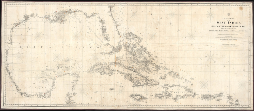
A General Chart of the West Indies, Gulf of Mexico and Caribbean Sea, showing the adjacent Coasts of the United States, Mexico, Central America, and the Spanish Main, to the Mouths of the Orinoco...
1863 (dated) 29.75 x 69.5 in (75.565 x 176.53 cm) 1 : 2350000
1863 (dated) 29.75 x 69.5 in (75.565 x 176.53 cm) 1 : 2350000
Description
This is Charles Copley and Sons' huge Civil War 1863 nautical map of the West Indies or Caribbean. Although printed in New York, Copley's charts were the best available privately published nautical charts of these waters. As such, they were coveted by Confederate Blockade Runners, who acquired them through the lucrative trade of intermediary sellers in Bermuda or the West Indies. This map was likely used by Confederate blockade runners in navigating between the Confederacy and the West Indies.
The tradition took off in the early 19th century, when British publishers like John Hamilton Moore, Robert Blachford, James Imray, William Heather, John William Norie, Charles Wilson, David Steel, R. H. Laurie, and John Hobbs, among others, rose to dominate the chart trade. Bluebacks became so popular that the convention was embraced by chartmakers outside of England, including Americans Edmund March Blunt and George Eldridge, as well as Scandinavian, French, German, Russian, and Spanish chartmakers. Blueback charts remained popular until the late 19th century, when government-subsidized organizations, such as the British Admiralty Hydrographic Office and the United States Coast Survey, began issuing their own superior charts on high-quality paper that did not require reinforcement.
A Closer Look
Measuring nearly 70 inches across, this large chart covers the Gulf of Mexico and the Caribbean Islands as far south as Jamaica, Hispaniola, and Puerto Rico. Soundings, bottoms, shoals, banks, currents, lighthouses (marked with red and yellow coloration), beacons, and other navigational information are included, especially in the difficult-to-navigate zones. Helpful notes appear throughout, such as 'good fishing' and 'Hill 100 ft.' On land, ports, cities, forts, railroads, and coastal features like hills, cliffs, and points are also noted. The chart names 'West Florida' and 'East Florida'. Compasses with magnetic variations appear at points. Very faint handwritten annotations add supplementary navigational information and track the course of a ship.Running the Blockade
Although originally prepared before the start of the U.S. Civil War (1861 - 1865), this edition was updated and published during the conflict. At the time, Confederate blockade runners often used islands in the Caribbean, particularly the Bahamas, to evade Union ships. Ships from other countries, which continued to trade with the Confederacy throughout the war, also would have been interested in the most up-to-date navigational information.Blueback Charts
Blueback nautical charts began appearing in London in the late 18th century. Bluebacks, as they came to be called, were privately published large-format nautical charts known for their distinctive blue paper backing. The backing, a commonly available blue manila paper traditionally used by publishers to wrap unbound pamphlets, was adopted as a practical way to reinforce the low-quality paper used by private chart publishers in an effort to cut costs. That being said, not all blueback charts are literally backed with blue paper. The earliest known blueback charts include a 1760 chart issued by Mount and Page and a 1787 chart issued by Robert Sayer.The tradition took off in the early 19th century, when British publishers like John Hamilton Moore, Robert Blachford, James Imray, William Heather, John William Norie, Charles Wilson, David Steel, R. H. Laurie, and John Hobbs, among others, rose to dominate the chart trade. Bluebacks became so popular that the convention was embraced by chartmakers outside of England, including Americans Edmund March Blunt and George Eldridge, as well as Scandinavian, French, German, Russian, and Spanish chartmakers. Blueback charts remained popular until the late 19th century, when government-subsidized organizations, such as the British Admiralty Hydrographic Office and the United States Coast Survey, began issuing their own superior charts on high-quality paper that did not require reinforcement.
Publication History and Census
This chart was prepared and published by Charles Copley and Sons in New York in 1863. It refers to a copyright date of 1858, but the present edition is the earliest we have been able to locate. We are aware of editions from 1864, 1865, and 1874, all very rare, but the present edition does not appear in any institutional collections or in recent market history.Cartographer
Charles Copley (1800 - November 17, 1880), was an American nautical chart and globe publisher based in Brooklyn, New York and active in the middle part of the 19th century. He was born in England and emigrated to the United States in the 1840s. He became a citizen in 1844. Charles Copley's earliest work is associated with the firm of E. and G. W. Blunt and his name appears as hydrographer or engraver on several of Blunt's c. 1840 charts – so he must have began working the Blunt shortly after emigrating. Around 1847 Copley began publishing independently, advertising himself as an engraver and map publisher. Most of his independent work was published in the 1850s. By 1860, the firm renamed itself Charles Copley and Son's, accommodating Charles John Copley Jr. (1826 - 18xx) and Frederick S. Copley (1827 - 18xx). From this point forward, most charts are copyrighted by 'C.C.J and F.S. Copley.' All Copley charts are extremely rare. More by this mapmaker...
Condition
Good. Full professional restoration. Mounted on blue linen. Soiling. Several closed tears extending 12 inches into printed area from left margin. Closed tear extending 27 inches from right margin.
References
OCLC 1481587935 (1865 ed.).