This item has been sold, but you can get on the Waitlist to be notified if another example becomes available, or purchase a digital scan.
1899 Goff Map of the West Indies
WestIndies-goff-1898$175.00

Title
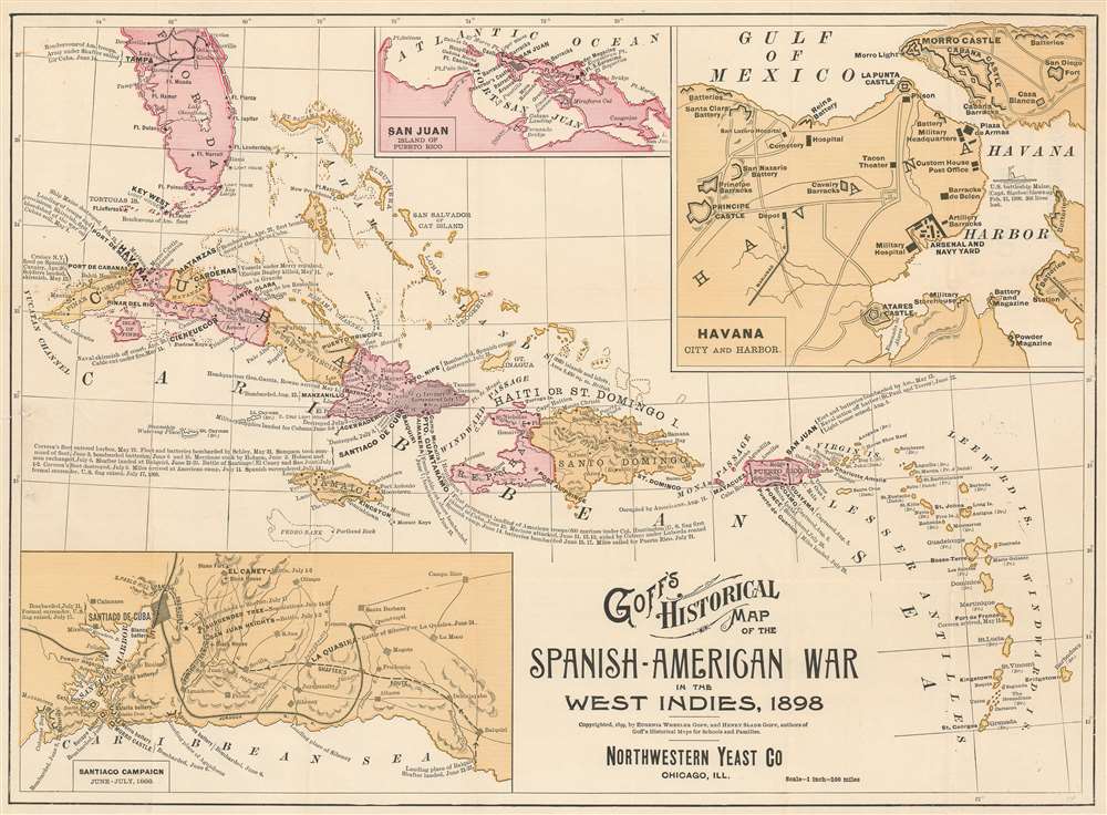
Goff's Historical Map of the Spanish-American War in the West Indies, 1898.
1898 (dated) 13.5 x 18.25 in (34.29 x 46.355 cm) 1 : 6336000
1898 (dated) 13.5 x 18.25 in (34.29 x 46.355 cm) 1 : 6336000
Description
This is a cartographically and typographically beautiful 1899 Eugenia Wheeler Goff and Henry Slade Goff map of the West Indies. The map depicts the region from the Yucatan Channel to Barbados and from Tampa, Florida to Grenada. Islands throughout the region are illustrated and labeled, including many of the Bahamas, Virgin Islands, and all the Lesser Antilles. Which colonial power claimed the island is also referenced. Color coding differentiates between provinces on Cuba, and, on Hispaniola or Santo Domingo Island. Three insets depict San Juan, Puerto Rico, Havana, Cuba, and the Santiago Campaign.
Spanish-American War Content
Captions of varying length present information about the Spanish-American War in the Caribbean. Many of these refer to specific events at a specific location, Havana, Santiago de Cuba, or Guantanamo for instance. The inset map of the Santiago Campaign in the lower left corner takes this a step further and offers a more detailed summary of the campaign. Specific battles are labeled and the route of American Major General William Shafter's force is depicted. Only one detail about the war is referenced in the inset of Havana, and that is the sinking of the U.S.S. Maine, which ignited the war.The Northwestern Yeast Company
The Northwestern Yeast Company was founded in Chicago in 1893 after Egbert W. Gillett, of the George A. Weiss Malting and Elevator Company, and John and Henry Boyle combined their firms. Gillett’s company sold ‘Magic Yeast’ while the Boyle’s firm sold their own brand of yeast, which they called ‘Yeast Foam’. After the merger, the company retained both products, most likely in an effort to avoid antitrust litigation. Although the ultimate fate of the business is unknown, it is known that the company was sued by employees claiming not to have been paid overtime and also faced antitrust issues in the 1940s. The factory was sold by 1950.Publication History and Census
This map was created by Eugenia Wheeler Goff and Henry Slade Goff in 1898 and this particular example was published by the Northwestern Yeast Company. Editions of this map were published as 'calling cards' for many different businesses, all of which are rare. We are aware of only one other example that bears the Northwestern Yeast Company imprint and it is part of the collection at the Library of Congress.CartographerS
Eugenia Almira Wheeler Goff (January 17, 1844 - May 12, 1922) was an American author, cartographer, historian, teacher, researcher, and publisher. Born in North Clarkson, Monroe County, New York, her parents, Joseph Lacy and Sarah Ann (Peck) Wheeler moved the family to Minnesota in 1859. In 1869 she graduated from State Normal School and was immediately employed there after her graduation and held the position for eight years, eventually attaining the rank of first assistant. She also taught in teachers' training school and state institutes in Minnesota for nine years. She wrote Minnestoa, Its Geography, History, and Resources, which was published in 1876 and later used in all common and graded schools across Minnesota. Her texbook was the first to combine history, resources, and geography, and proved to be so popular that publishers used her ideas to publish books for other states. She also created series of historical maps and charts, which would be published after her marriage to Henry Slade Goff by their publishing company. She married Henry Slade Goff on July, 19, 1882, and she and her husband founded the National Historical Publishing Company in 1887, which published the aforementioned maps. Over the ensuing twenty-five years, Eugenia undertook the historical research and designed over 100 different historical maps and charts, which ranged in size from that of a book to large wall maps. Together, the Goffs wrote and published and historical atlas, The United States and Her Neighbors, in 1893. In 1894, Eugenia Goff was nominated to run for the Minneapolis school board, and garnered the support of women throughout the city as well as the endorsements of the Prohibitionist, Populist, and Democratic parties. Even so, she came in fourth with a total of 13,164 votes. Eugenia Goff died on Friday, May 12, 1922, at her home in Minneapolis. More by this mapmaker...
Henry Slade Goff (April 23, 1842 - June 19, 1917) was an American historian, author, poet, and publisher. Born in West Winfield, New York, Goff established a homestead claim in Blue Earth County, Minnesota, in 1861 with his brother. A truly frontier life, Goff enlisted in Company B, 1st Minnesota mounted rangers to help protect his homestead and others, eventually rising to corporal. Goff and his regiment participated in several battles during the Indian war in Minnesota and the Dakotas. Goff also served in the Union Army during the American Civil War. In 1874 Goff graduated from Minnesota Normal School, Mankato and the enrolled in a postgraduate course at the University of Minnesota. Over the course of his career he taught in both rural and high schools, served as a superintendent of schools, and taught in the state teachers' training schools and at the University of Minnesota. Goff cowrote the historical atlas The United States and Her Neighbors with his wife Eugenia Wheeler Goff (January 17, 1844 - May 12, 1922) and also wrote numerous articles and poetry. He married his first wife, Josephine Stevens, on July 19, 1866, and she passed away only a few years later in 1872. He then remarried, to Eugenia Almira Wheeler, on July 19, 1882. Learn More...
Condition
Very good. Closed tear extending one quarter inch into printed area professionally repaired on verso. Light wear and toning along original fold lines. Some text on verso.
References
Library of Congress G4901.S1 1899 .G6.