This item has been sold, but you can get on the Waitlist to be notified if another example becomes available, or purchase a digital scan.
1700 Pierre Mortier Chart / Map of Florida, West Indies, Caribbean, Central America
WestIndies-mortier-1700$1,750.00

Title
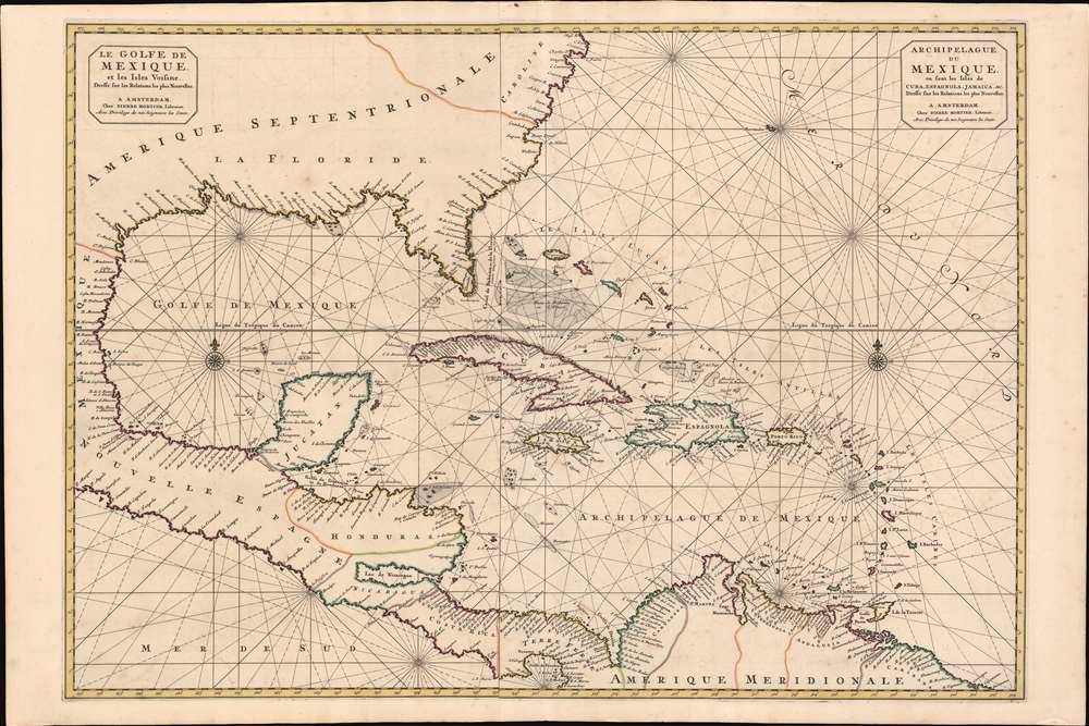
Le Golfe de Mexique et les Isles Voisine Dressé sr les Relations les plus Nouvelles. / Archipelague du Mexique, ou sont les Isles de Cuba, Espagnola, Jamaica, et c. Dressé sur les relations les plus Nouvelles.
1700 (undated) 25 x 37.25 in (63.5 x 94.615 cm) 1 : 5000000
1700 (undated) 25 x 37.25 in (63.5 x 94.615 cm) 1 : 5000000
Description
A scarce and striking 1700 Pierre Mortier nautical map embracing Florida, the Gulf of Mexico, Central America, the West Indies, and the Caribbean. Presented on two sheets, joined at center by the publisher, it is centered on Cuba, but extends broadly from Cape Lookout to the Gulf of Darien and from Mexico to Bermuda, Surinam, and Barbados.
Sources
Mortier's sources are unclear. We recognized the mapping of the mouth of the Mississippi River (Meschasipi) as closely following the 1698 Hennepin map - reflecting the most up-to-date, if fictitious, reconnaissance. The shape of Florida and the Gulf littoral have been tenuously attributed to manuscripts of N. P. d'Ablancourt, themselves derived from Portuguese manuscripts. Meanwhile, some of the nomenclature in Carolina suggest English sources. Regarding the unusual, inverted triangle shape of Florida, we see few precedent analogs, save possibly the Samuel Thornton chart of 1683, although that connection is weak at best. In terms of antecedent maps that may have used this as a source, we note the 1720 Herman Moll West Indies. Here the term 'Florida' itself is used to refer to the entirety of the Spanish northern Gulf littoral from Texas to Hilton Head.Publication History and Census
This map was drawn by Pierre Mortier in 1700 - one of nine new maps inserted in the Suite de Neptune François, the second volume of his 1693 Neptune François. Unlike the other maps in the Suite, this one is exceptionally rare as it had only a two-year print run, after which it was replaced by the Teatre de la Guerre en Amerique, focusing on the War of Spanish Succession. The OCLC notes just three examples: University of Florida, Florida State, and University of Texas.Cartographer
Pierre Mortier (January 26, 1661 - February 18, 1711) or Pieter Mortier was a cartographer, engraver, and print seller active in Amsterdam during the later 17th and early 18th centuries. Mortier, then known as Pieter, was born in Leiden. He relocated to Paris from 1681 to 1685, adopting the French name Pierre, which he retained throughout his career. While in France, he developed deep French connections by bringing sophisticated Dutch printing technology and experience to nascent French map publishers such as Guillaume De L'Isle (1675 - 1726), Alexis-Hubert Jaillot (c. 1632 - 1712), and Nicholas de Fer (1646 - 1720). Consequently, much of Mortier's business was built upon issuing embellished high quality editions of contemporary French maps - generally with the permissions of their original authors. In the greater context of global cartography, this was a significant advantage as most Dutch map publishes had, at this point, fallen into the miasma of reprinting their own outdated works. By contrast, the cartographers of France were producing the most accurate and up to date charts anywhere. Mortier's cartographic work culminated in the magnificent nautical atlas, Le Neptune Francois. He was awarded the Privilege, an early form of copyright, in 1690. Upon Pierre's death in 1711 this business was inherited by his widow. In 1721, his son Cornelius Mortier took over the day to day operation of the firm. Cornelius partnered with his brother-in-law Jean Covens to form one of history's great cartographic partnerships - Covens and Mortier - which continued to publish maps and atlases until about 1866. More by this mapmaker...
Source
Mortier, P., Suite de Neptune François, ou atlas nouveau des cartes marines, (Amsterdam: P. Mortier) 1700.
Condition
Very good. Slight foxing. Original centerfold.
References
OCLC 51953714. Burden, P., The Mapping of North America II, #769.