1822 Franz Pluth Map of the West Indies
WestIndies-pluth-1822$225.00

Title
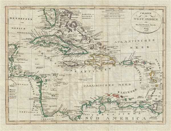
Charte von West_Indien oder den Antillischen_Inseln.
1822 (dated) 12.25 x 16.5 in (31.115 x 41.91 cm) 1 : 7900000
1822 (dated) 12.25 x 16.5 in (31.115 x 41.91 cm) 1 : 7900000
Description
This is a rare 1822 map of the Caribbean prepared by Czech engraver Franz Pluth. The map depicts the region from the Yucatan Peninsula to the islands of Martinique, St. Lucia, and Trinidad and Tobago and from southern Florida and the Bahamas to northern South America, then referred to as 'Terra Firma'. Highly detailed and beautifully colored, nearly all of the islands in the region are identified, including numerous islands in the Bahamas, Jamaica, the Virgin Islands, Guadeloupe, Grenada, and Curaçao. The coasts of Cuba, Hispaniola, and Jamaica are illustrated in detail, with numerous locations identified on each of these islands. Cozumel is labeled off the coast of Mexico as well. The colors utilized here were not simply chosen for their aesthetic qualities; in fact, they refer to the colonial power in possession of the territory at the time. A key along the left border informs the viewer that territory bordered in green was Spanish, territory bordered in purple was English, and so on.
This map was produced by Franz Pluth in 1822.
This map was produced by Franz Pluth in 1822.
Cartographer
Franz Pluth (1800 - 1871) was an engraver based in Prague, the capital of the Kingdom of Bohemia, then part of the Habsburg Austrian Empire. Pluth was born in Prague and most likely died in Zbraslav. He was active as a map engraver until at least 1848. His work is similar in style to that of Karl Ferdinand Weiland, a prolific German engraver, with whom he may have worked. More by this mapmaker...
Source
Linder, F. L., Neueste Länder - und Völkerkunde, ein geographisches Lesebuch für alle Stände. , (Prague) 1820.Linder's book is typically dated 1820, but contains maps dated between 1816 and 1825.
Condition
Very good. Light wear along original fold lines. Light transferrence. Blank on verso.