This item has been sold, but you can get on the Waitlist to be notified if another example becomes available, or purchase a digital scan.
1811 Russell Map of the West Indies
WestIndies-russell-1811$175.00

Title
West Indies.
1811 (dated) 14.5 x 18.5 in (36.83 x 46.99 cm) 1 : 6865000
1811 (dated) 14.5 x 18.5 in (36.83 x 46.99 cm) 1 : 6865000
Description
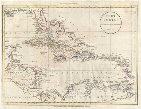
This is an 1811 John Russell map of the West Indies and Central America. The map depicts the region from the Yucatan Peninsula to the Lesser Antilles and from Florida to northern South America, including Colombia and Venezuela. A remarkable amount of underwater detail is included, particularly off the coast of Belize, Honduras, and Nicaragua, labeled here as 'Mosquito Shore'. The same level of detail is present along the coast of Cuba and in the Bahamas. Grand Cayman, Jamaica, Puerto Rico, the Virgin Islands, St. Lucia, Barbados, and Trinidad and Tobago are among the other islands identified. Myriad locations, both in Central America and in the West Indies, are labeled along the coastline and inland. Nicaragua Lake is easily discernable. In South America, Lake Maracaibo, a brackish tidal bay in Venezuela, is also labeled. Along the coast of the United States, New Orleans, Mobile Fort, and Cape Canaveral are labeled, along with the mouth of the Mississippi River.
This map was produced and engraved by John Russell and published by Wilkie and Robinson and J. Mawman in 1811.
This map was produced and engraved by John Russell and published by Wilkie and Robinson and J. Mawman in 1811.
Cartographer
John Russell (c. 1750 - 1829) was a British cartographer active in London during the late 18th and early 19th centuries. Russell apprenticed as a goldsmith under William Palmer before turning to engraving and printing. He drew maps and engraved for several major publishers of his period including Alexander Dalrymple, Benjamin Henry, Robert Sayer, John Moore, and William Guthrie. Russell's 10 apprentices included such prominent cartographers as Alexander Findlay and Samuel Clapp. Russell was based on Constitution Row Grays Inn Lane, Middlesex (London). More by this mapmaker...
Source
Guthrie, W., A New System of Modern Geography (London) 1811.
Condition
Very good. Light transference. Verso repairs to fold separations. Blank on verso.