This item has been sold, but you can get on the Waitlist to be notified if another example becomes available, or purchase a digital scan.
1769 Tirion Map and Chart of the West Indies, Caribbean Sea
WestIndies-tirion-1769-2$450.00

Title
Algemeene Kaart van de Westindische Eilanden.
1769 (undated) 13.75 x 17.75 in (34.925 x 45.085 cm) 1 : 7200000
1769 (undated) 13.75 x 17.75 in (34.925 x 45.085 cm) 1 : 7200000
Description
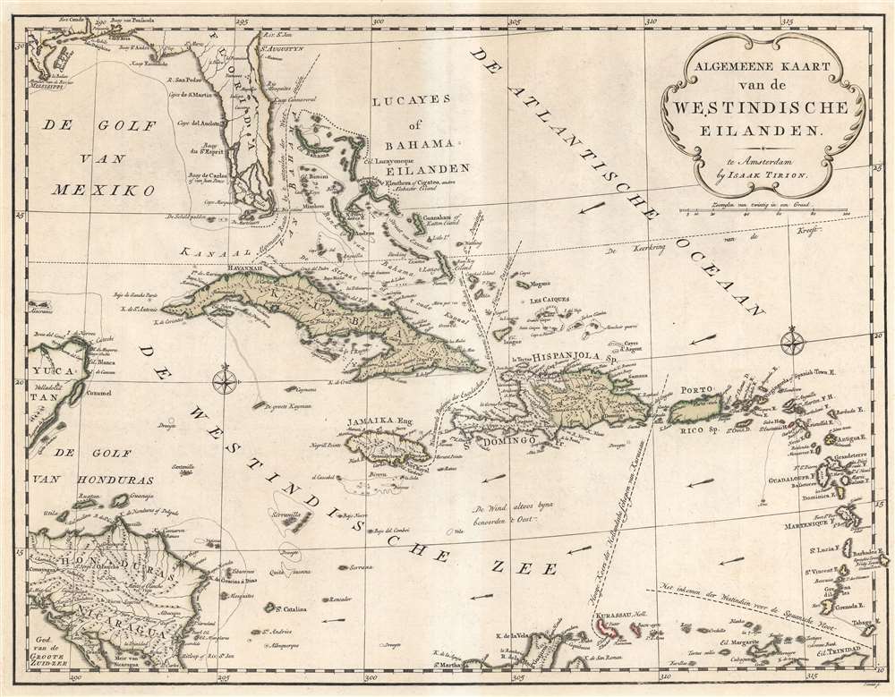
This is a 1769 Isaak Tirion map and chart of the West Indies. It depicts the region in the wake of the Seven Years' War (1756 - 1763), which followed decades of competition between European powers in the Caribbean and largely settled the map of the Americas until the upheavals of the Age of Revolution.
Islands and other territories are 'color coded' to indicate their inclusion in the colonial empires of competing European powers (Spanish as brown, French as pink, English as yellow, Dutch as orange, Danish as green), though this is not maintained at bottom and left, where Spanish territories are outlined in green. Notably, this map was produced soon after Florida became a British territory, as part of the 1763 Treaty of Paris ending Seven Years' War, which saw additional exchanges of French territory in the Americas to Britain.
Locations along coastlines are labeled as well, including Cape Canaveral, the modern-day home of the Kennedy Space Center. Reefs and other hazards are also noted. Prevailing winds blowing from east to west are demonstrated with arrows.
Perhaps the most intriguing aspect of this map is the inclusion of numerous trade routes around the Caribbean. Piracy was a common practice during the 18th century and, by including common trade routes, cartographers could create another clientele for their work. Numerous cartographers, notably Herman Moll, included such notations in his work. The most common route noted by these cartographers, and Moll in particular, was that of the Spanish galleon fleet, a frequent target of attack by Dutch and later English privateers. Tirion notes and labels the traditional entrance of the Spanish fleet into the Caribbean between Grenada and Trinidad, in the lower right. The Dutch route to Curaçao threading between Hispaniola and Puerto Rico is included, along with the English route to Jamaica and the French passage to Hispaniola / Santo Domingo. The 'most common route in the West Indies,' which was used by at least the Spanish fleet and probably others, is labeled as such and illustrated in the Florida Strait between the Bahamas and Florida.
A Closer Look
Coverage stretches from the Yucatan Peninsula and Honduras and Nicaragua to the Lesser Antilles and from Florida to the extreme northern portion of South America. Numerous islands throughout the Caribbean Sea are labeled, including Cuba, Hispaniola, Puerto Rico, the Bahamas, the Virgin Islands, Martinique, Guadeloupe, Antigua, Barbuda, St. Lucia, Curacao, and Cozumel, among others.Islands and other territories are 'color coded' to indicate their inclusion in the colonial empires of competing European powers (Spanish as brown, French as pink, English as yellow, Dutch as orange, Danish as green), though this is not maintained at bottom and left, where Spanish territories are outlined in green. Notably, this map was produced soon after Florida became a British territory, as part of the 1763 Treaty of Paris ending Seven Years' War, which saw additional exchanges of French territory in the Americas to Britain.
Locations along coastlines are labeled as well, including Cape Canaveral, the modern-day home of the Kennedy Space Center. Reefs and other hazards are also noted. Prevailing winds blowing from east to west are demonstrated with arrows.
Perhaps the most intriguing aspect of this map is the inclusion of numerous trade routes around the Caribbean. Piracy was a common practice during the 18th century and, by including common trade routes, cartographers could create another clientele for their work. Numerous cartographers, notably Herman Moll, included such notations in his work. The most common route noted by these cartographers, and Moll in particular, was that of the Spanish galleon fleet, a frequent target of attack by Dutch and later English privateers. Tirion notes and labels the traditional entrance of the Spanish fleet into the Caribbean between Grenada and Trinidad, in the lower right. The Dutch route to Curaçao threading between Hispaniola and Puerto Rico is included, along with the English route to Jamaica and the French passage to Hispaniola / Santo Domingo. The 'most common route in the West Indies,' which was used by at least the Spanish fleet and probably others, is labeled as such and illustrated in the Florida Strait between the Bahamas and Florida.
Publication History and Census
This map was created by Isaak Tirion, engraved by Johannes Condet, and published in Amsterdam c. 1769 in Hedendaagsche historie, of Tegenwoordige Staat van Amerika, the third volume in a translation of Thomas Salmon's Modern History, or the Present State of all Nations…. The OCLC has independent catalog listings of this map at nine institutions in Europe and North America, while the Hedendaagsche historie… is somewhat more broadly distributed, especially in the Netherlands, though it is cataloged with a wide variety of dates.Cartographer
Isaak Tirion (1705 - 1765) was a Dutch publisher in Amsterdam. Born in Utrecht, Tirion quickly rose to prominence by publishing pamphlets, historical works, and most importantly, maps and atlases. He produced several atlases and Dutch town plans. His maps are mainly based on those of Guillaume de l'Isle. Tirion eventually relocated his printing house to the prestigious Kalverstraat. In his long career, he produced eight atlases in multiple editions, some of which were published posthumously until about 1784. More by this mapmaker...
Source
Salmon, T., Hedendaagsche historie, of Tegenwoordige Staat van Amerika, (Amsterdam: Tirion) 1769.
Condition
Good. Centerfold more lightly toned than surrounding map. Margins, along with two strips at top-left and top-right, likewise lightly toned due to matting and framing.
References
OCLC 494226918, 950610197, 54451481, 216076430.