
1941 Petersen World War II Westinghouse Strategic War Map of Europe

Westinghouse Strategic War Map.
Stanley Turner's first War Events Map? Weeks before the Nazi invasion of Russia.
$300.00
Choose a Collection:
- Digital Map Information
- Suitable for large format printing
- Full resolution TIFF file
- ICC color profile embedded
- Delivered instantly via download link
This Item
Enquire
Stanley Turner's first War Events Map? Weeks before the Nazi invasion of Russia.
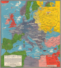
This is a 1941 Petersen / Westinghouse / Turner map of Europe embroiled in World War II (1939 - 1945), published weeks before the June 22, 1941, German invasion of the Soviet Union. The map chronicles events from the Anschluss of Austria in 1938 and the Nazi invasion of Poland on September 1, 1939, until June 3, 1942. While unsigned, this map was most likely drawn by Stanley Francis Turner, who went on to complete a popular series of similar maps for Westinghouse chronicling the progress of war. It is likely, thus, that this is Turner's first 'war map.'A Closer Look
Coverage embraces Europe, including England, Russia, and Scandinavia, as well as adjacent parts of northern Africa and western Asia. Text boxes trace the war's progress: the invasions of the Low Countries, the Nazi invasion of France, and the partition of Poland between the Soviet Union and Germany, the evacuation at Dunkirk, the British evacuation of Greece, and the 1940-41 offensives in North Africa. Flags mark capital cities and icons highlight key natural resources.Germany is shaded dark gray, while occupied territory throughout Europe is lighter gray. Intriguingly, Italy is the same shade of gray as Poland, Denmark, Belgium, the Netherlands, and Occupied France. Perhaps the author is trying to make a point about Italy's worthiness as a Nazi ally. Neutral countries are green, including Sweden, Switzerland, Spain, and Unoccupied France (along with Morocco and Algeria - French colonies in North Africa). The only Allied nation is Britain, shaded dark red. Egypt also appears in dark red and was technically neutral, but it served as the primary staging area for British troops in North Africa and the Middle East throughout the war. The Soviet Union is yellow. At this point, the U.S.S.R. was an ally of Nazi Germany after signing a nonaggression pact with Nazi Germany. Parts of Europe occupied by the Soviets following the Nazi invasion of Poland are shaded light yellow. However, Germany would launch a surprise invasion of the Soviet Union only weeks after this map was published.
Stanley Francis Turner?
Stanley Francis Turner (1883 - 1953) was a visual artist and painter based in Toronto, Canada, who made a series of maps during World War II entitled Dated Events War Map, along with variations on that theme. Turner's maps are data-rich and include pictorial elements, much like the present map. In this case, the map is unsigned. The striking similarity between the present map and Turner's work, along with the fact that later editions of the Westinghouse War Map are signed by Turner, has led us to speculate that this work was also done by Turner.Publication History and Census
This map was created for the Canadian Westinghouse Company and published by C.C. Petersen Advertising in mid-June 1941. These maps were advertised in Ontario newspapers and given away free by Westinghouse agents. We note a single cataloged example, which is part of the David Rumsey Map Collection.Cartographer
C. C. Petersen (fl. c. 1940 – 1950) was an advertising and publishing company based in Toronto Canada, but with distribution and licensing in both the United States and Canada. Petersen had contracts with the artist Stanley Francis Turner to publish pictorial 'war maps' during World War II. The company supplemented its income by selling advertisements on Turner's maps. Further Details...
Condition
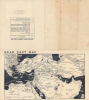
Very good. Light wear along original fold lines. Addenda and a map of the Near East on verso.
References
Rumsey 11136.001.