This item has been sold, but you can get on the Waitlist to be notified if another example becomes available, or purchase a digital scan.
1929 Admiralty Nautical Chart or Maritime Map of the Huangpu River, Shanghai
Whangpoo-admiralty-1929$475.00

Title
China The Whangpoo.
1929 (dated) 49.5 x 26.5 in (125.73 x 67.31 cm) 1 : 20000
1929 (dated) 49.5 x 26.5 in (125.73 x 67.31 cm) 1 : 20000
Description
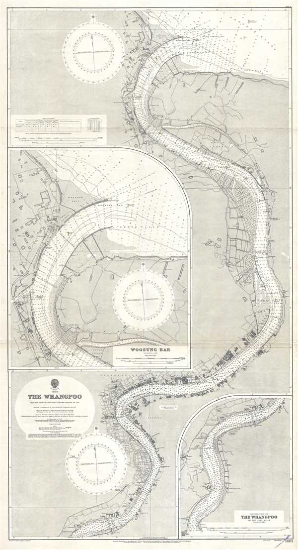
This is a 1929 British Admiralty nautical chart or maritime map of the Huangpu (Whangpoo) River. Centered on Shanghai and the International Settlement, the map depicts the region along the river from just south of Shanghai to the river's mouth, where it empties into the Yangtze River. Highly detailed, myriad depth soundings measured in feet are included along the whole length of the river, allowing for ease of navigation. Navigational hazards, including wrecks, are noted, as are lights both within the river and along its banks. Buildings are illustrated along the entire length of the river, with the International Settlement labeled in large block letters. The British Consulate, the Russian Consulate, the United States Consulate, and the Japanese Consulate all are explicitly labeled. Two inset maps, one depicting the Woosung Bar and the other depicting a continuation of the Huangpu above where the main chart ends, are included. One, the chart of the Woosung Bar, is situated along the left border, while the continuation of the Huangpu is in the lower right corner.
This chart was published by the Admiralty in 1929.
This chart was published by the Admiralty in 1929.
Cartographer
The British Admiralty Office (1795 - Present) or the United Kingdom Hydrographic Office refers to the Branch of the English government that is responsible for the command of the British Navy. In 1795 King George III created the United Kingdom Hydrographic Office, known in short as the U.K.H.O., to provide top notch nautical charts to the vast Royal Navy. Prior the founding of the Admiralty the surveying and creation of nautical charts was primarily a commercial venture wherein the cartographer himself, more of than not, actually financed the printing of his own material. The great navigator Cook himself is known to have scrambled for funds to publish his own seminal charts - the most important and advanced of the period. The system of privately funded nautical mapping and publishing left vast portions of the world uncharted and many excellent charts unpublished. King George III, responding significant loss in trade revenue related to shipwrecks and delay due to poor charts, recognized the need for an institutionalized government sponsored cartographic agency - the Admiralty. The first head of the Admiralty, a position known as Hydrographer, was the important cartographer Alexander Dalrymple. Dalrymple started by organizing and cataloging obtainable charts before initiating the laborious process of updating them and filling in the blanks. The first official Admiralty Chart appeared in 1800 and detailed Quiberon Bay in Brittany. By 1808 the position of Hydrographer fell to Captain Thomas Hurd. Hurd advocated the sale of Admiralty charts to the general public and, by the time he retired in 1829, had issued and published some 736 charts. Stewardship of the organization then passed to Rear Admiral Sir Francis Beaufort. It was under Beaufort's administration that the Admiralty truly developed as a "chart making" as opposed to a "chart cataloging" institution. Beaufort held his post from 1829 to 1854. In his 25 years at the Admiralty Beaufort created nearly 1500 new charts and sponsored countless surveying and scientific expeditions - including the 1831 to 1836 voyage of the H.M.S. Beagle. By 1855 the Admiralty's chart catalog listed some 1,981 charts. More by this mapmaker...
Condition
Very good. Even overall toning. Light wear along original fold lines. Blank on verso.