
1940 Eddy Pictorial Map of Europe During World War II

This item has been sold.
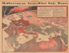
Mediterranean Area -- What Italy Wants.
Published the day before Hitler invaded Belgium, the Netherlands, and France.
- Digital Map Information
- Suitable for large format printing
- Full resolution TIFF file
- ICC color profile embedded
- Delivered instantly via download link
Published the day before Hitler invaded Belgium, the Netherlands, and France.
Published the day before Hitler's Germany invaded Belgium, Luxembourg, the Netherlands, and eastern France, this is a Gerald Eddy pictorial map of Europe published in the Milwaukee Sentinel on May 9, 1940. The map captures a moment in history before Europe and the world plunged into the depths of World War II (1939 - 1945).A Closer Look
Eddy utilizes a novel perspective by incorporating the Earth's curvature into this piece. North Africa is in the foreground, with French, Italian, and British colonies labeled as such and shaded different colors. A dashed line labeled 'England's Life Line to India' runs from the Gulf of Aden through the Red Sea and the Mediterranean to the Atlantic and north to Britain. A British soldier stands astride the Suez Canal and holds British warships on leashes that are spread across the Mediterranean as far west as Malta, protecting this lifeline. Another British soldier stands across the Strait of Gibraltar and holds more warships on leashes, protecting the other bottleneck in this tenuous connection to India and its vast resources.Mussolini stands in Rome (near center and marked by an illustration of St. Peter's Basilica), with his navy on leashes anchored at Sardinia, Sicily, Fiume, in the Adriatic between Italy and Albania, and in the Aegean in the Dodecanese Islands. Stalin is looking over events from the east on the coast of the Black Sea with his navy on leashes and anchored along the coasts of Crimea. A French soldier stands on the border between France and Spain and holds the French Navy's leashes as it sits at anchor at Marseille. Paris dominates northern France with a giant Eiffel Tower prominently illustrated. Hitler is looking over the Alps and has locked eyes with Mussolini, apparently trying to communicate something. Moscow and London appear farther in the background. Norway is on fire in the upper-left corner, having been subjected to a German invasion beginning on April 9. German bombers are illustrated attacking Oslo.
An Incredible Illustration
In hindsight, perhaps the most striking aspect of this incredible map is the Maginot Line and the West Wall separating France and Germany (which is blood red and expanded to include annexed Austria and divided Poland), respectively. The French believed that the Maginot Line (a series of fortifications they had built after World War I) was impenetrable. This hubris would prove disastrous, after Germany invaded on May 10, 1940, and a series of German battlefield victories compelled the French to surrender and sign an armistice only six weeks later.The Textbox
The textbox in the upper left quadrant recounts Italy's belief that the Mediterranean Sea is 'their sea'. It chronicles Italian demands, including that the British and French should demilitarize their bases all along the Mediterranean coast (notably Gibraltar and Suez) and that the French should relinquish control of the terminus of the Addis Ababa railroad.Publication History and Census
This map was drawn by Gerald Eddy and published on April, 9, 1940, in the Milwaukee Sentinel. This is the only known cataloged example.Cartographer
Gerald Allen Eddy (October 12, 1889 - September 9, 1967) was an American artist. Born in Michigan, Eddy's parents either divorced or his father died between 1900 and 1910. In 1910 Eddy was living with his mother, brother, and stepfather in Los Angeles and working as an artist. Eddy was a prolific cartographer and created numerous maps of different areas of the western United States. He married Madolyn M. Smith on January 18, 1911. By 1917, the couple had one daughter, according to his World War I draft card. By 1919, Eddy was drawing views for newspapers in southern California. By 1939 Eddy was a staff artist for the San Francisco Call-Bulletin and drew courtroom sketches and maps for the newspaper. By 1940 his maps would be syndicated in newspapers across the country. He was married to his wife Madolyn when he died. Further Details...
Condition
Good. Newsprint. Several closed tears along top border that enter printed title. Text on verso.