
1902 National Publishing Map of the White Mountains, New Hampshire

This item has been sold.
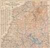
The National Publishing Company's Topographic Map of the White Mountains and Central New Hampshire.
The Whites.
- Digital Map Information
- Suitable for large format printing
- File Size: 76.02 MB
- File Type: ZIP / TIFF
- ICC color profile embedded
- Delivered instantly via download link
The Whites.
This is a 1902 National Publishing Company map of the White Mountains and central New Hampshire. Coverage embraces central New Hampshire from Lancaster and Berlin Mills south to Cornish, South Danbury, and Alton Bay. Many individual peaks throughout the White Mountains are noted. Cities, towns, and villages are labeled, with communities served by post offices and railroad stations labeled as such. Grants and purchases around the area are labeled in different typefaces, with some marked in large bold lettering, while others, like the Allen grant in Waterville County, are much less noticeable. Roads are illustrated, as are several railroads, including the Northern Division and the White Mountain Division of the Boston and Maine Railroad and several abandoned lumber railroads. Counties are demarcated and identified, and rivers and lakes are colored blue and labeled. Mountains are illustrated using contour lines, labeled, and their elevations provided. An index along the left side lists post offices, railroad stations, principal lakes and streams, and principal mountains, and provides the grid location for each one.Publication History and Census
This map was created and published by the National Publishing Company of Boston, Massachusetts in 1902. We are aware of one institutional example which is part of the collection at the Norman B. Leventhal Map Center at the Boston Public Library and at least two others that are part of private collections.Cartographer
National Publishing Company (1897 - 1902) was an American map publishing firm founded in Portland, Maine in 1897. The founders, brothers Walter C. Scarborough (June 4, 1862 - May 9, 1904) and Howard G. Scarborough (December 23, 1867 - June 10, 1905), were also proprietors of the Scarborough Company and the Dominion Publishing Company. The National Publishing Company was intended to be managed by Howard, with Walter serving as treasurer. By 1901, the firm had relocated to Boston, where it published and sold large scale brilliantly printed road maps. In 1902, the Scarborough brothers merged their three concerns into the Boston based Scarborough Company and opened an office in Indianapolis, Indiana. Walter and Howard died in 1904 and 1905, both from tuberculous, but the Scarborough Company continued, transferring its offices to Indianapolis. In 1913 it became the Scarborough Motor Guide Company (c. 1913 - c. 1933). It does not appear to be related to the more prominent general publisher of the same name based out of Philadelphia. Further Details...
Condition
Very good. Mounted on linen. Light wear and toning along original fold lines.
References
Boston Public Library Norman B. Leventhal Map Center G3742.W52C2 1902 .N38.