This item has been sold, but you can get on the Waitlist to be notified if another example becomes available, or purchase a digital scan.
1887 Wiggins and Wiggins City Plan or Map of Wichita, Kansas
Wichita-wiggins-1887$212.50

Title
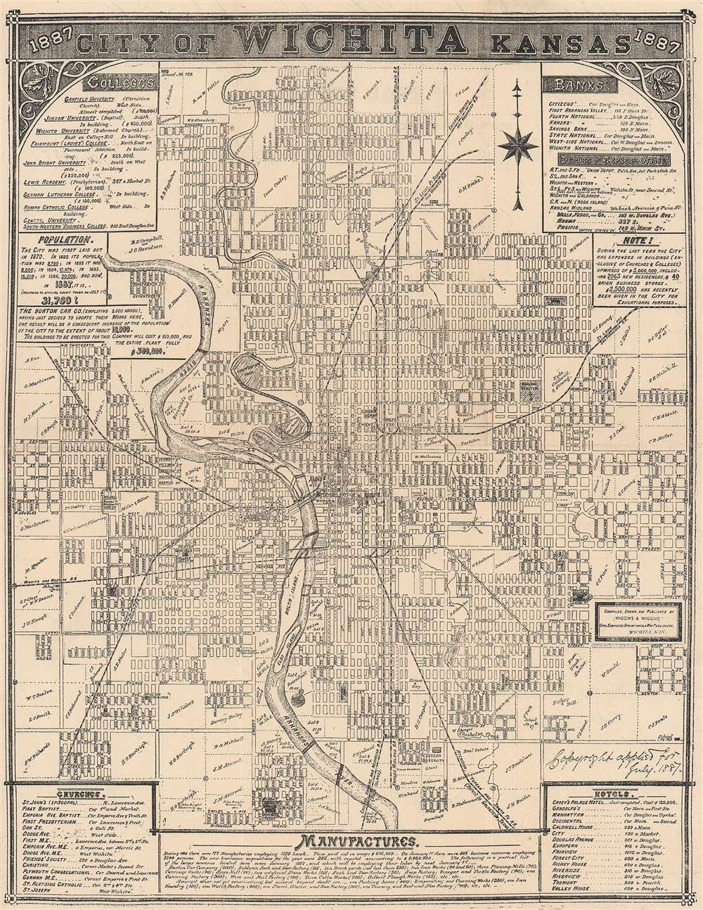
City of Wichita Kansas.
1887 (dated) 10.5 x 8 in (26.67 x 20.32 cm)
1887 (dated) 10.5 x 8 in (26.67 x 20.32 cm)
Description
This is an 1887 Wiggins and Wiggins city plan or map of Wichita, Kansas. Large private landholdings around town are illustrated and identified by the owner's first initial and last name, with most of these situated on the outskirts of town. However, some, such as 'W. Mathewson' and Ford and Firebaugh's tracts, appear within the city's planned street grid. Parks, hotels, schools, Garfield College, and Fairmount College are illustrated and labeled. Seven railroads, including the 'St. Louis and San Francisco Railroad', the 'St. Louis, Ft. Scott, and Wichita Railroad', the 'Chicago, Kansas, and Nebraska Railroad', and the 'Atchison, Topeka, and Santa Fe Railroad' service Wichita, making the town a transportation hub in the late 19th century. Textboxes along the top and bottom borders list Wichita's banks, colleges, churches, hotels, and factories.
Verso Content
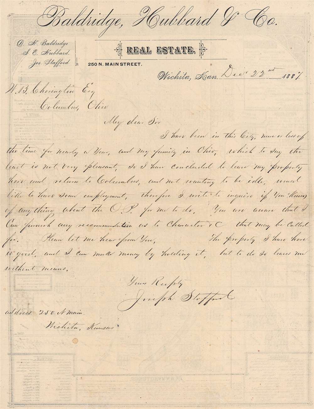
A handwritten letter appears on verso. Written by Joseph Stafford, he addresses a professional in Columbus seeking employment. He states that he had been in Wichita for a year and decided that he wanted to return to Columbus to be with his family.Publication History and Census
This map was compiled, drawn, and published by Wiggins and Wiggins in 1887. The firm advertised this map in local Wichita newspapers in 1887. The present example has stationery for Baldridge, Hubbard, and Company Real Estate printed on the verso. This is the only known example of the present edition (with stationery on the verso). An OCLC listing exists cataloging two facsimiles of a map bearing the same title, date, and publisher, which is part of the collection at the Library of Congress. The facsimiles are part of the collections at the University of Kansas and the Wichita Public Library. As the dimensions of the facsimiles do not match the dimensions of the presently offered piece, we believe the presently offered piece to be a slightly reduced version of Wiggins and Wiggins' original map created for use as stationery. We note no other cataloged examples of the present edition.Cartographer
Edward W. Wiggins (1832 - January 19, 1912) was an English American civil engineer, cartographer, and map publisher. Born in Oxford, England, Wiggins arrived in the United States in October 1858. Wiggins was making maps in Wichita, Kansas, as early as 1886. He dissolved a partnership with a Mr. Smith in March 1887 to establish a partnership with his nephew Thomas Wiggins known as Wiggins and Wiggins, of which records only exist dating from 1887 and they published maps of Wichita and Sedgwick County, although it is unclear if the partnership survived the year. The Southwestern Map Company was founded in 1891 and Wiggins was the manager. He worked for the Southwestern Map Company until at least 1896. Wiggins operated E. W. Wiggins and Company, 'makers and publishers of maps' in Wichita in 1901 and continued making maps in Wichita and around Kansas until at least 1903. He died in Chicago in 1912. More by this mapmaker...
Condition
Very good. Light wear along original fold lines. Verso repairs to fold separations. Manuscript letter written on letterhead on verso.