
1907 Hartleben Pictorial Monumental Map of Vienna, Austria



This item has been sold.
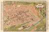
Wien aus der Vogelschau Plan von Wien mit sämtlichen Monumental-Bauten.
Vienna's many buildings and monuments illustrated in monumental fashion.
- Digital Map Information
- Suitable for large format printing
- Full resolution TIFF file
- ICC color profile embedded
- Delivered instantly via download link
Vienna's many buildings and monuments illustrated in monumental fashion.
This is a beautiful c. 1907 Hartleben pictorial monumental map of Vienna, Austria. 155 locations are illustrated pictorially and numerically identified throughout the city, including St. Stephen's Cathedral (No. 1), the Rathaus (No. 41), and the Arsenal (No. 105). Forty-nine more locations (many of which are monuments) are illustrated and alphabetically identified. The extensive indexes occupy the left and right margins outside the map. Prominent red lines trace Vienna's tram network.Publication History and Census
This map was created by Freytag and Berndt and published by Hartleben Publishing c. 1907. We note a single cataloged example in OCLC which is part of the collection at the Staatsbibliothek zu Berlin. It is rare on the private market.Cartographer
Freytag and Berndt (1770 - Present) is a map, atlas, guidebook, and travel literature publisher. Its roots reach back to when Francesco Artaria founded a lithographic works in Vienna in 1770. In February 1879, Gustav Freytag founded a cartographic publishing house. Freytag and Berndt merged with the cartographic division of Artaria in 1920. After World War II, Freytag-Berndt und Artaria experienced expanded publication to become one of the most important cartographic publishers in Central Europe. Today, Freytag and Berndt publishes street maps, city map, hiking maps, and cycling maps and employs fifty cartographers and editors at their headquarters in Vienna. Further Details...
Condition
Good. Light wear along original fold lines. Light dampstaining not visible on recto. Small areas of loss at some fold intersections. Closed margin tears professionally repaired on verso.
References
OCLC 1184458453.