1895 Goldmann Map of the Witwatersrand Gold Fields, Johannesburg
Witwatersrand-goldmann-1895$5,500.00

Title
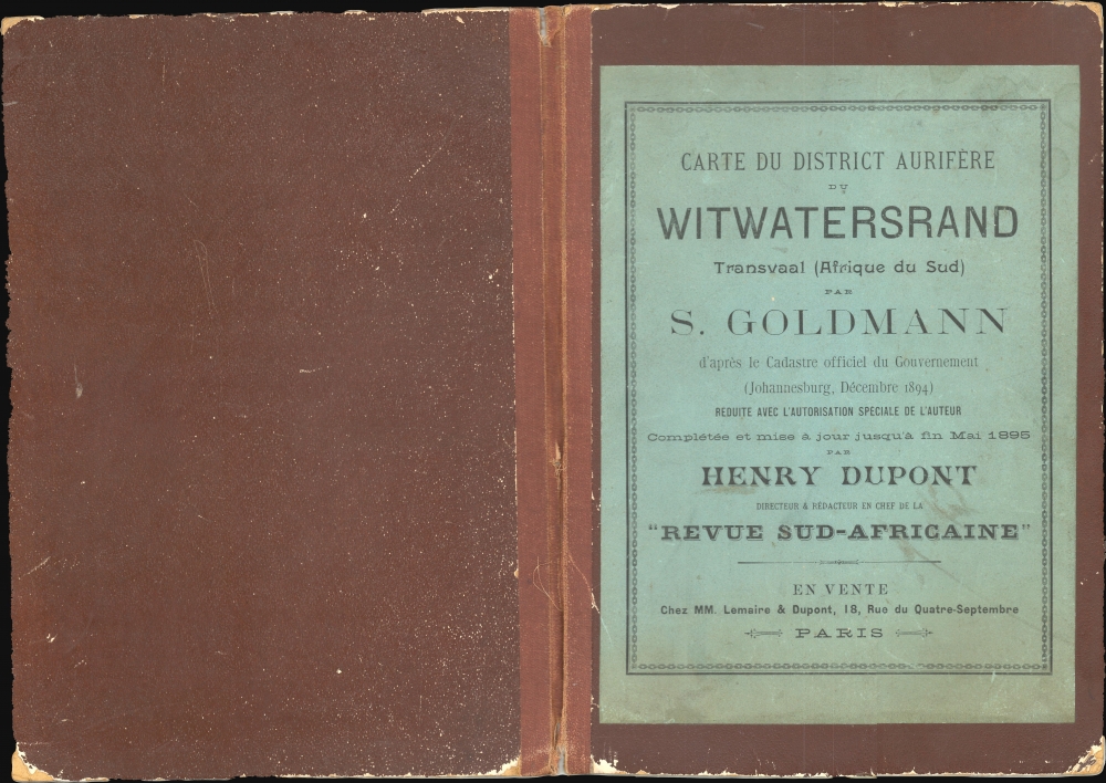
Carte du District Aurifère du Witwatersrand. Transvaal - Afrique du Sud. A'après le cadastre officiel du gouvernement.
1895 (dated) 28.5 x 79 in (72.39 x 200.66 cm) 1 : 47000
1895 (dated) 28.5 x 79 in (72.39 x 200.66 cm) 1 : 47000
Description
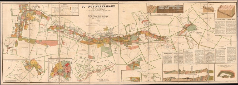
A rare and stunning 1895 large-format folding cadastral map of gold claims during the Witwatersrand Gold Rush, prepared by the appropriately-names Charles Sydney Goldman, printed by Langonnet et Langlet, and published by Henry Dupont. It demonstrates the evolution of mining methods and the rapid growth of Johannesburg and surrounding towns with the influx of miners.
Townships, now neighborhoods or suburbs of Johannesburg, are clearly displayed with geometric grids and are connected by a significant and growing network of railways. Surrounding the map are diagrams, inset maps, and text providing geologic and geographic information on the Witwatersrand. At top-right, two diagrams explain deep-level mining operations and the digging of wells (puits), which were increasingly necessary as the easy-to-access gold on surface outcroppings was quickly snatched up. Insets at bottom display the Heidelberg District (southeast of Johannesburg), the Transvaal as a whole, the Klerksdorp District (southwest of Johannesburg), and the Northern Extension (north of the city). At bottom-right are a geologic map and two geologic cross-sections of the Witwatersrand region, as well as a text portion explaining the geology of the region, mining operations to date, and future prospects, (correctly) concluding that tremendous amounts of gold could continue to be extracted for decades to come.
Measures, in the form of taxation and other restrictions, were taken by the Boer government to prevent control of the region from falling to the foreigners, or uitlanders, to little effect. As in other gold rush contexts, restrictions were also placed on the property rights of non-Whites, including Black Africans and Chinese, Indian, and other migrant laborers. The tensions between the British, being led by 'randlord' mining magnates like Rhodes, and the Boers eventually led to the disastrous Jameson Raid at the end of 1895 and the Second Boer War (1899 - 1902). The mines were shut down and the British and Boers threw themselves at one another with a vengeance. After marshalling huge armies, the British were able to subdue the Boer Republics, and move down the path of incorporation into a South African union. The gold rush had profound and lasting effects on the Witwatersrand region and South Africa as a whole, leading to increased immigration, urbanization, and industrialization, as well as the exploitation of labor and racial segregation.
A Closer Look
Covering lands corresponding to today's Johannesburg and surrounding suburbs, this map provides an intricate catalog of claims to the Witwatersrand Gold Reef, running in an east-west strip across a portion of the Transvaal. A legend at top-left explains the outlines, symbols, and coloration of the map, employing and translating between a combination of English, French, and Afrikaans. The green outlines display the borders and owners of farms predating the gold rush, while red solid and dashed lines mark out the outcroppings (affleurements) or 'reefs' of gold-bearing ore. Most noticeably, claims are labelled with color-shading; some owners are individuals and small-time operations, while other claims belong to larger estates and conglomerations, usually agents of the 'randlord' mining magnates. Not visible in the scan, but apparent upon viewing the map in person, is gilt highlighting further emphasizing the location of gold deposits.Townships, now neighborhoods or suburbs of Johannesburg, are clearly displayed with geometric grids and are connected by a significant and growing network of railways. Surrounding the map are diagrams, inset maps, and text providing geologic and geographic information on the Witwatersrand. At top-right, two diagrams explain deep-level mining operations and the digging of wells (puits), which were increasingly necessary as the easy-to-access gold on surface outcroppings was quickly snatched up. Insets at bottom display the Heidelberg District (southeast of Johannesburg), the Transvaal as a whole, the Klerksdorp District (southwest of Johannesburg), and the Northern Extension (north of the city). At bottom-right are a geologic map and two geologic cross-sections of the Witwatersrand region, as well as a text portion explaining the geology of the region, mining operations to date, and future prospects, (correctly) concluding that tremendous amounts of gold could continue to be extracted for decades to come.
The Witwatersrand Gold Rush
This map was issued during the Witwatersrand Gold Rush, which can be traced to 1884 but which began in earnest in 1886. The Boers, who dominated the region following the Great Trek of the 1830s, were mostly farmers, and few had the technical skills to exploit the newly discovered mines. Nonetheless, word got out of the gold discovery. When the wealth of the Witwatersrand Reef was fully understood, thousands flocked into the region, creating one of the largest gold rushes in history. The city of Johannesburg sprang up in short order, similar to other gold rush cities like San Francisco and Melbourne, and within a decade eclipsed Cape Town. Over the same timeframe, South Africa, starting from scratch, came to supply one-quarter of the world's gold. British diamond magnates, including Cecil Rhodes and Barney Barnato, maneuvered to seize control of the Witwatersrand Reef and its massive potential wealth.Measures, in the form of taxation and other restrictions, were taken by the Boer government to prevent control of the region from falling to the foreigners, or uitlanders, to little effect. As in other gold rush contexts, restrictions were also placed on the property rights of non-Whites, including Black Africans and Chinese, Indian, and other migrant laborers. The tensions between the British, being led by 'randlord' mining magnates like Rhodes, and the Boers eventually led to the disastrous Jameson Raid at the end of 1895 and the Second Boer War (1899 - 1902). The mines were shut down and the British and Boers threw themselves at one another with a vengeance. After marshalling huge armies, the British were able to subdue the Boer Republics, and move down the path of incorporation into a South African union. The gold rush had profound and lasting effects on the Witwatersrand region and South Africa as a whole, leading to increased immigration, urbanization, and industrialization, as well as the exploitation of labor and racial segregation.
Publication History and Census
This map was prepared by Charles Sydney Goldman (or Goldmann) in 1895, printed by Langonnet et Langlet, and published by Henry Dupont, whopublished a regular journal La Revue Sud-Africaine focusing exclusively on the British controlled South African mining industry. His cartographic output includes a similar, though smaller, 1902 cadastral map of Johannesburg (also sold by us). The present map is quite scarce, only being noted among the holdings of five institutions in the OCLC, all of which are in Europe or South Africa. It is equally rare on the private market, only appearing once in recent years.CartographerS
Charles Sydney Goldman (Goldmann) (April 28, 1868 - April 7, 1958) was British adventurer, businessman, author, journals, and politician primarily active in South Africa during the early late 19th and early 20th century. Goldman was a German Jew was born in the Cape Colony. He spent his early years in Germany, before moving to England and, ultimately, returning to the Cape Colony, where became extremely wealthy during the 1886 Witwatersrand Gold Rush. During the Boer War he enlisted as a Major and worked with Winston Churchill as a war correspondent for the Standard. After the First Boer War he focused on developing the gold resources of the Witwatersrand Ridge, preparing a highly detailed map of the region, illustrating gold claims, which was published in Paris in 1895. During the Second Boer War he was a special correspondent with Sir Redvers Buller in Natal and later with Lord Roberts on the South African Campaign. Also during the war, he married Agnes Mary Peel (1869–1959), a daughter of 1st Viscount Peel. After the British takeover of the Transvaal at the end of the Second Boer War, Goldman returned to England where he purchased The Outlook, a weekly sporting magazine, which he leveraged to garner political influence. In 1910, furthering his political ambitions, he ran for Parliament, taking the Penryn and Falmouth seat in a general election as a Unionist. During World War I he served as a major in the Cornwall Royal Garrison Artillery. Following the war, his Parliament seat was abolished and he again began to look to the colonies. In 1919, Goldman used part of his gold-mining fortune to purchase a vast tracking of land in British Columbia's Nicola Valley, which he named Nicola Stock Farm. He again returned to England living for a time at Trefusis House, in Falmouth, until roughly 1929, when he retired to the Jacobean estate of Yaverland Manor on the Isle of Wight. After a long and exciting life, Goldman died in British Columbia in 1958. More by this mapmaker...
Langonnet et Langlet (fl. 1885 - 1903) was a French firm established by the draughtsmen Langonnet et Langlet, who became partners in 1885. They created a special studio, which allowed them to produce more work than if they had worked on their own. They moved around Paris several times: from the Rue de Lancry to the Faubourg-Saint-Martin, before finally setting up shop at 124 and 126 Rue Lafayette in 1894. By 1900, they had fifteen draughtsmen working for them. Besides reproducing etchings, they also produced drawings meant to be reproduced by photo-lithography, helio-zincography, photogravure, and simili-gravure. The firm produced few maps, but did issue several important maps for the Revue Sud-Africaine and at last one of the Kondike gold region. Learn More...
Condition
Very good. Original linen backing. Folds into original binder.
References
OCLC 48474890. Afriterra #1849.