Digital Image: 1886 Lester and Williams Map of Woodstock, Connecticut
WoodstockConn-lesterwilliams-1886_d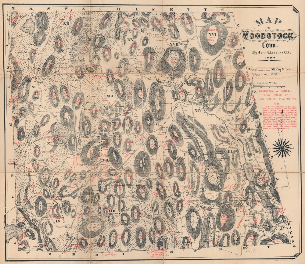

Title
Map of Woodstock, Conn.
1886 (dated) 24.5 x 28 in (62.23 x 71.12 cm) 1 : 21120
1886 (dated) 24.5 x 28 in (62.23 x 71.12 cm) 1 : 21120
Description
FOR THE ORIGINAL ANTIQUE MAP, WITH HISTORICAL ANALYSIS, CLICK HERE.
Digital Map Information
Geographicus maintains an archive of high-resolution rare map scans. We scan our maps at 300 DPI or higher, with newer images being 600 DPI, (either TIFF or JPEG, depending on when the scan was done) which is most cases in suitable for enlargement and printing.
Delivery
Once you purchase our digital scan service, you will receive a download link via email - usually within seconds. Digital orders are delivered as ZIP files, an industry standard file compression protocol that any computer should be able to unpack. Some of our files are very large, and can take some time to download. Most files are saved into your computer's 'Downloads' folder. All delivery is electronic. No physical product is shipped.
Credit and Scope of Use
You can use your digial image any way you want! Our digital images are unrestricted by copyright and can be used, modified, and published freely. The textual description that accompanies the original antique map is not included in the sale of digital images and remains protected by copyright. That said, we put significant care and effort into scanning and editing these maps, and we’d appreciate a credit when possible. Should you wish to credit us, please use the following credit line:
Courtesy of Geographicus Rare Antique Maps (https://www.geographicus.com).
How Large Can I Print?
In general, at 300 DPI, you should at least be able to double the size of the actual image, more so with our 600 DPI images. So, if the original was 10 x 12 inches, you can print at 20 x 24 inches, without quality loss. If your display requirements can accommodate some loss in image quality, you can make it even larger. That being said, no quality of scan will allow you to blow up at 10 x 12 inch map to wall size without significant quality loss. For more information, it is best consult a printer or reprographics specialist.
Refunds
If the high resolution image you ordered is unavailable, we will fully refund your purchase. Otherwise, digital images scans are a service, not a tangible product, and cannot be returned or refunded once the download link is used.
Cartographer S
George Clinton Williams (September 5, 1825 - 1901) was born in West Woodstock, Connecticut. He attended Yale College and graduated in 1847, then studied law with his father (who was a judge) and in 1849 was admitted to the bar. He worked in the Naval and Treasury Departments in Washington, D.C. for a few years and then became solicitor and chief of the organization division of the Bureau of National Currency in 1867. After his time in the Bureau of National Currency he served as the brigade quartermaster and inspector on General Elihu Geer's staff. In 1886, he annotated John S. Lester's map of Woodstock, Connecticut, with topographical and historical names. More by this mapmaker...
The Heliotype Printing Company (1872 - c. 1900) was a printing company based in Boston. The company was promoted as 'artistic printers by the best photogelatine and photolithographic processes.' They were reorganized in 1885, adapting chromolithographic and photo reprographic techniques. They remained active until at least the 1930s. Their offices were located at 211 Tremont Street, Boston. Learn More...
References
OCLC 5473776.