This item has been sold, but you can get on the Waitlist to be notified if another example becomes available, or purchase a digital scan.
1572 Arias Montanus Map of the World
World-ariusmontanus-1572$4,875.00

Title
Benedict Arias Montanus Sacrae Geographiae Tabulam Ex Antiquissimorum Cultor.
1572 (dated) 12.5 x 21 in (31.75 x 53.34 cm) 1 : 129000000
1572 (dated) 12.5 x 21 in (31.75 x 53.34 cm) 1 : 129000000
Description
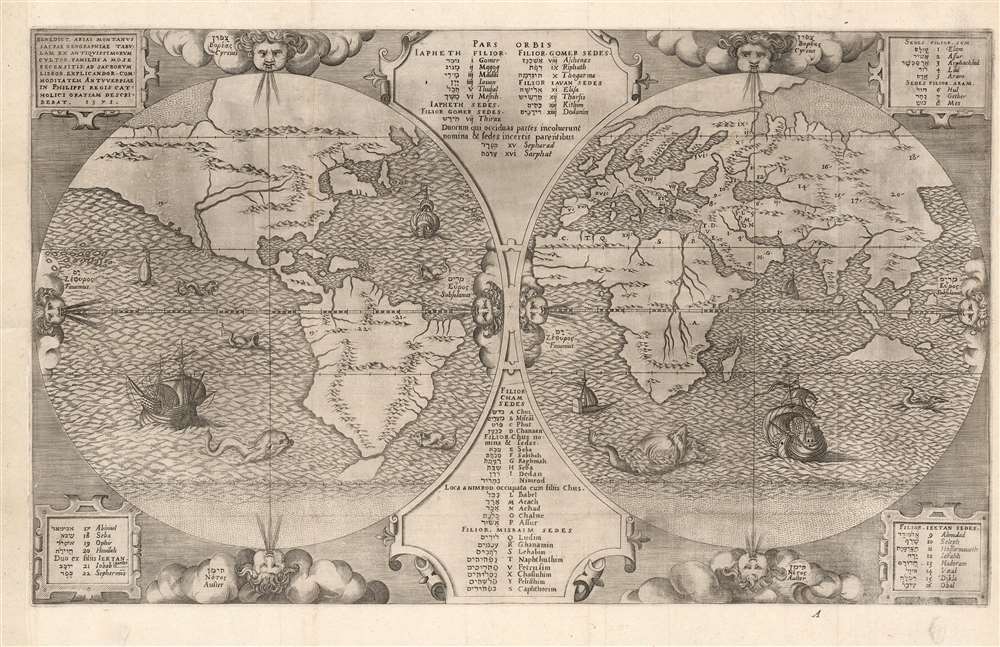
This is a scarce and important 1571 map of the world by Benedict Arias Montanus. Finely engraved and prepared for the eight-volume Plantin Polyglot Bible, this elegant map was intended to bring the new discoveries of the Americas into a coherent religious context. It further established the Native American population as Hebrew descendants of Noah, and thus Children of God whom the dedicatee of the Polyglot, Philip II of Spain, was obliged to convert. Although its alleged revelations of Australian geography have long been the map's cause celebre, these are overshadowed by the map's actual significance as a cartographic justification of Spanish Imperialism.
Complete volumes of the Biblia Sacra are reasonably well represented in institutional collections, though their dating is inconsistent We are aware of only six separate examples of this map cataloged in institutions, two of which prove on examination to be the 1660 third plate. The University of Washington, Princeton University, and the Israel Museum in Jerusalem possess examples of the first state. The British Library appears to have the second state.
The Map
The map is the first-known double-hemispheric world map in a Bible, and virtually the earliest acquirable full-size double-hemisphere map of the world printed overall, predated only by the smaller 1561 Ruscelli and the unacquirable 1555 Calapoda map. (The form was not an innovation, but did not appear in an 'atlas' until Ruscelli.) Montanus' map, appearing as it did in a Bible, was intended for religious study. Specifically, it was drawn to illustrate the re-population of the Earth by the descendants of Noah following the Deluge, and to include the population of the New World in that number. The names of these descendants and their tribes are listed in Hebrew, Latin, Greek, and Aramaic, with numbers and letters keying the names to locations. In particular, the settlements of Ophir, Jobab, and Sephermos - all sons of Shem - are in the Americas. Thus, this indicates, for the first time on a map, that after the Great Flood the children of Noah repopulated not only the Old World, but also the New. This was not an academic issue, particularly for Philip II: it is a clear statement of the humanity of the Native Americans, carrying with it Philip's responsibility to convert them.Gold in the West
Of the many numbered and named names on the map, it is notable that one - #19 Ophir - appears twice. The Biblical Ophir was famed for its wealth, and it was written (1 Kings 10:22) that King Solomon received a cargo of gold, silver, sandalwood, pearls, ivory, apes, and peacocks from that city every three years. Ophir's location is marked with the number '19' in South America in the region of Peru, as well as in North America in the vicinity of California. The co-location of Ophir does not seem to be an error, so much as a statement of uncertainty: explorers, after all, had not conclusively identified the true location Ophir, but by the 1570s the Spanish had been extracting vast wealth from Peru for nearly forty years, and they had continued to seek cities of gold further north throughout the period. It was a reasonable assumption that, were Ophir to be anywhere, it might have been in these remote parts of the Americas. It is possible (see below) that the location of Ophir in Peru is connected to the semi-legendary trade city of Cattigara, which in early 16th-century geography migrated from its classical location in Southeast Asia to the shores of the Sinus Magnus, and later to the Pacific Coast of South America.The Ruscelli Model
Montanus's delineation of the world was not invented: he was a scholar and orientalist but not a geographer. He relied on existing geographic frameworks, in this case, the 1561 Ruscelli. Features on the Montanus shared by the Ruscelli include:- A clear (or at least strongly implied) connection between North America and Asia.
- The distinctive river system extending from the Gulf of California into the middle of the continent, and the pattern of imaginary mountain ranges in North America.
- An insular Northeast, possibly derived from Gastaldi's connection of the Hudson River with the Saint Lawrence, and possibly influenced by the Sea of Verrazano.
- The overall shape of South America, including its pattern of mountains and rivers.
- An insular Tierra del Fuego.
- The depiction of the Arctic landmasses.
- The delineation of Africa, including the scattering of islands north of Madagascar.
- The absence on the map of the southern continent dominating the southern hemispheres of most other maps of the period, notably the Ortelius.
Remarkable Deviations
Geographically, the map diverges from Ruscelli in several areas. Both the Montanus and the Ruscelli show Tierra del Fuego as an island; the Ruscelli completes the bottom coast with a dotted line, indicating ambiguity; Montanus extended the incompleted coasts further south. Likewise, Montanus' southernmost East India island, likely Java, is without a southern shore and with its northern coasts extending broadly before fading into the ocean. The Ruscelli depiction of Java is much more limited, but its southern coast is dotted in the same manner as Tierra del Fuego. Viewed in context with maps more contemporaneous than the Ruscelli, it appears most likely that Montanus was familiar with the southern continent appearing (for example) on the Ortelius, and was amending his model to make it more consistent with contemporaneous scholarship by leaving the possibility open that such a Terra Australis might exist. Ortelius, with whom Montanus was friendly, connected both Tierra del Fuego and New Guinea to a Terra Australis Nondum Cognita.. Terra Australis itself was a supposed massive continent occupying much of the southern hemisphere presumed to exist based upon the venerable writings of Aristotle. Most maps following Magellan's 1522 circumnavigation follow the model laid down by Oronce Fine in 1531, which connected Tierra De Fuego to Terra Australis. This remained the convention until the early 17th century when cartographers assimilated the discoveries of Sir Francis Drake.But Australia?
The landmass appearing - incomplete - in the Southeast Asian archipelago has unleashed an unconscionable volume of ink over the years with respect to its 'Australitude', about which even Shirley was dubious.There is an unusual island shown in the position of Australia which has given rise to speculation, although in common with other spurious land masses off the east coast of America(By this, Shirley means the insular Northeast)
it probably represents no more than the engraver' license.In this last, Shirley is unfair. Montanus, although starting from (and mostly adhering to) the Ruscelli map, was able to make his map more consistent with contemporaneous cartographic thinking by leaving his southernmost landmasses ambiguous as to their extent. So while it is not impossible that Montanus, or for that matter Ortelius, had been informed of some otherwise unrecorded Portuguese or Spanish discovery of land in the vicinity of Australia prior to the Dutch, it is not likely that it is represented here.
Earlier Seeds
The notion that Terra Australis might include Java or some other Southeast Asian island may be a legacy of the Dieppe School Maps which, dating to the 1540s, illustrated a large landmass just south of the Island of Java called Java La Grande or even Land of Java. Typically in these manuscript maps Java La Grande is shown connected to some version of Terra Australis extending to the South Polar regions. The landmass, in both the Ruscelli and the Montanus, shares the northernmost terminus of the Dieppe School maps, but they do not resemble the long, narrow form indicated on them.Marco?
It is unclear what informed the Dieppe School cartographers with respect to Java Grande. It may be that they were interpreting part of the Marco Polo narrative, referring to land to the south of Java which he describes as 'an extensive and rich province that forms a part of the mainland.' It is also possible that Ruscelli was aware of Ludovico di Varthema's reports from his 1505 visit to Java, referring to people far to the south who traveled by the stars (indigenous Australian navigators). It is also possible that Java Grande reflects actual observations of the Australian mainland by Portuguese (or possibly French) navigators on their way to or from the Indies. Navigators in the early 16th century guarded their secrets closely, and so it is not unreasonable that there would be no surviving mention of either the voyages or their discoveries. So, while it is unlikely that Montanus (or Ruscelli for that matter) was representing an actual discovery of Australia, it reflects an ongoing cartographic thread that may have its roots in actual discovery.Ophir and the Land Bridge to America
One key distinction between the Montanus and the Ruscelli is that although both show Asia and America to be contiguous, the Montanus does so much more decisively: the 1561 Ruscelli connects the two with a dotted Pacific coast marked 'Littus Incognitum' (unknown coast) whereas the Montanus does so with solid coastline, absent any caveat. This was fundamentally important to Montanus - he explicitly proposed that Native Americans were descendants of post-flood Hebrews who migrated to the Americas via an Asian land bridge. His goal here is thus to reconcile the discoveries in the New World with the Bible, in which it was written that the whole population of the world was descended from the children of Noah. A land connection between Asia and America provided a necessary explanation for both the migration of human beings from the Biblical lands to the New World, and also for the routes by which Ophir's gold (and monkeys, and peacocks) would be delivered to King Solomon, in Jerusalem. Other candidates for the location of the historical Ophir had been the fabled trade city of Cattigara, which appeared on the far shore of the Sinus Magnus on early maps. With the discovery and early mapping of the Americas, Cattigara began to be illustrated on the Pacific coast of South America, and the appearance of Ophir in that vicinity on Montanus' map is consistent. As for the Ruscelli, this region bears the legend 'Cast. del Oro', thus reinforcing Montanus' connection of the place with Ophir.Fine Engraving
The map itself is beautifully engraved. The waved and stippled oceans are populated with sea monsters and sailing ships, and the four cardinal directions are marked with wind-heads on each hemisphere. The variations in the engraving of these, in particular, aid the scholar in differentiating the different versions of this map that were engraved over the course of the map's century-long publication history.Publication History and Census
This map exists in three known plates, the first of which is known in two states.- 1571 First Plate, State 1
- 1572 First Plate, State 2 (Our example)
- 1572+ (?) Second Plate
- c. 1660 Third Plate
Complete volumes of the Biblia Sacra are reasonably well represented in institutional collections, though their dating is inconsistent We are aware of only six separate examples of this map cataloged in institutions, two of which prove on examination to be the 1660 third plate. The University of Washington, Princeton University, and the Israel Museum in Jerusalem possess examples of the first state. The British Library appears to have the second state.
Cartographer
Benedict Arias Montanus (1527 - 1598), also known as Benito Arias Montano, was a Spanish orientalist and polymath active in Spain during the second half of the 16th century. Montanus studied in Seville and Alcala and joined the Benedicting order in 1559. He later became a clerical member of the militant monastic Order of St. James. Arias Montanus is best known for editing the eight-volume Antwerp Polyglot Bible. This work contains several important maps, including a world map that some consider to be the first mapping of Australia (although it was printed well before Australia as officially discovered). Arias Montanus was a friend and correspondent with Abraham Ortelius, who encouraged his interest in cartography. His Polyglot Bible however came under scrutiny of the Spanish and Roman inquisitions for its liberal use of rabbinical texts to elucidate parts of the Bible. He was cleared of charges in 1580 and accepted a post as Royal Chaplain to Philip II of Spain. Afterwards he became the superintendent of the Escorial Library and a master of Oriental languages. More by this mapmaker...
Source
Arias, Benedictus Montanus, Biblia Sacra, Hebraice, Chaldaice, Graece… , (The Polyglot Bible), Volume 8, (Antwerp), 1572.
Condition
Very good. Original fold lines. Left margin extended with no loss. Some wear at junctures of folds; else excellent.
References
OCLC 558030918. Brekka, Pamela Merrill, The Antwerp Polyglot Bible (1572): Visual Corpus, New World 'Hebrew-Indian' Map, and the Religious Crosscurrents of Imperial Spain Dissertation, Graduate School of the University of Florida, 2012. Shirley, Rodney W., The Mapping of the World: Early Printed World Maps 1472-1700, no. 125, plate 107. State 2, plate 1. Suarez, T, The Early Mapping of the Pacific, page 79. Australia in Maps: Great Maps in Australia's History from the National Library's Collection, pages 24-25.