This item has been sold, but you can get on the Waitlist to be notified if another example becomes available, or purchase a digital scan.
1839 Gilbert World Map (Comparative Mountains Rivers, Republic of Texas)
World-gilbert-1838$625.00

Title
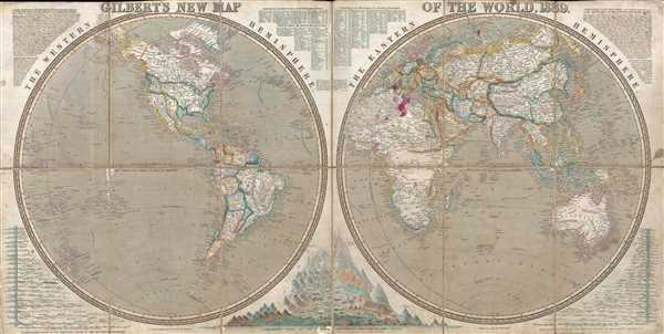
Gilbert's New Map of the World, 1839.
1838 (dated) 18.5 x 37 in (46.99 x 93.98 cm) 1 : 47850000
1838 (dated) 18.5 x 37 in (46.99 x 93.98 cm) 1 : 47850000
Description
This is a scarce and fascinating 1839 separate issue James Gilbert and Joshua Archer world map in two hemispheres. The map depicts the world split into the Eastern and the Western hemispheres. Several different intriguing details are included here, such as Texas as a republic, the extension of the northern border of the United States well into modern British Columbia, which led to the 54° 40' dispute, and the inclusion of comparative tables of the mountains and rivers of the world.
Perhaps the most innovative aspect of this particular map is the integration of the comparative mountains and rivers charts alongside the world map. Typically, comparative mountains and rivers charts were added to 19th century atlases as separate plates. This chart, on the other hand, adds them to the world map using a sophisticated system that divides both mountains and rivers by hemisphere. As such, the cartographer was extremely prescient and this map remarkably advanced for an 1839 production. To our knowledge, the next published map of the world to embrace such an integration did not appear until the 1880s. A reference chart for the mountains is situated along the top border between the two hemispheres (the numbers in the reference chart match the numbers on the mountains) and the chart itself is located along the bottom border between them. The two rivers charts are situated in the lower left and right corners, both of which note the cities located along the banks of the rivers and the body of water into which the river empties.
The inclusion of the Republic of Texas on this map is of exceptional interest. Since Gilbert's New Map of the World is not an American map, but an English one, the choice to include Texas as a Republic is significant. The Republic of Texas had only been declared in 1836 and, although it maintained a consulate in London, was not officially recognized by most European powers. Gilbert's addition of the secessionist republic as such both suggests that he may have been a Texas advocate and that he was embracing the most advanced cartographic information available.
The extension of the Pacific Northwest border of the United States is not depicted at the 49th parallel, which is the contemporary border between the United States and Canada, but rather at the parallel 54°40' north, which was the border with Russian America and well into modern day British Columbia. This is highly unusual for a British map and suggests the cartographer may have been an American sympathizer. The Oregon Question was disputed for decades between the United States and Great Britain. The basis for the dispute was mostly economic. The early 19th century fur trade in the Pacific Northwest was booming, which meant that both British and American companies and citizens wanted access to this area. American interest was also influenced by Manifest Destiny, the founding of the Astoria settlement by John Jacob Astor, and the drive for Westward Expansion. Although a border was agreed upon at the 49th parallel by 1846, the crisis was not fully resolved until 1872.
Countries are differentiated by color and are highly detailed. Myriad cities are labeled, as well as locations along all the coastlines, rivers, lakes, and mountain ranges. Routes followed by several explorers, including Captains Gores and Cook, are illustrated.
Extremely rare, one example of this map is identifiable in public collections and we have been able to pinpoint only a single example in private hands. It would be a wonderful addition to any collection, in particular those focused on the 19th century evolution of comparative mountains and rivers charts. This map was drawn and engraved by Joshua Archer and published by James Gilbert and E. Grattan in 1839.
CartographerS
James Gilbert (fl. c. 1839-1850) was an English cartographer active in London. Little is known about Gilbert himself, nonetheless the promotional material for his maps is quite laudatory. More by this mapmaker...
Joshua Archer (c. 1792 - 1863) was an English cartographer, copperplate printer, and engraver active in London. He was born at Barnstaple in Devon. He produced maps for Robert Wilkinson, William Pinnock, Ernest Hawkins, and the ‘British Magazine’. Like most engravers, Archer struggled financially and declared bankruptcy in 1835. In the 1841 Census he was recorded simply as an engraver and as living with his wife Jane and a son and was in prison for debt in 1845. In the 1861 Census, he was recorded as a map and chart engraver, and as living with Jane, a son John Archer (also a map and chart engraver), Albert Archer (a map and chart draughtsman), and his wife and three children. Joshua Archer’s death was registered at Islington. Learn More...
Condition
Very good. Backed on linen. Wear along the fold lines with some slight loss. Red ink stain located in eastern hemisphere, North Africa. Blank on verso.
References
OCLC 222961048.