1630 / 1641 Hondius / Jansson Map of the World
World-hondius-1630
Title
1630 (dated) 15 x 21.5 in (38.1 x 54.61 cm) 1 : 50000000
Description
A Closer Look
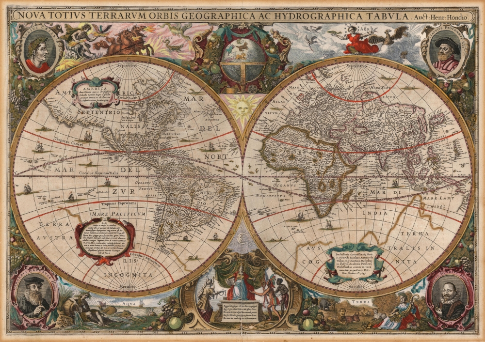
This map was produced as part of Hondius and Jansson's efforts to bring the work of Jodocus Hondius and Mercator up to date and make it more competitive with Blaeu's publications. This necessitated not only more up-to-date cartography but also more fashionable and elaborate decorative elements than the relatively staid map that appeared in the Mercator/Hondius atlas.The map is presented on two hemispheres: a celestial globe is depicted above the crux of the hemispheres. Below the crux, is a vignette of Europa, enthroned, with the avatars of Asia, America, and Africa approaching as supplicants rendering tribute. The quarters of the map present vignettes dedicated to the elements: Earth, Air, Fire, and Water. Medallions in each corner contain portraits of Julius Caesar, Claudius Ptolemy, and the mapmakers' precursors Gerard Mercator and Jodocus Hondius.
Cartographic Lineage
Many elements are drawn from the 1626 map engraved by Abraham Goos for John Speed. The details of the English colonies in North America, in Virginia and Plymouth are very clearly sourced from that work. Like Goos, the younger Hondius and Jansson drew on the 1617 Jodocus Hondius map, so the maps share many similarities. For example, in the North Atlantic, the fraudulent geography of Nicolo Zeno is made evident by the presence of the phantom island Frisland, east of Labrador. This shares space with the actual discoveries of Martin Frobisher from his 1576 voyage, including 'Queen Elizabeth's Foreland' on the coast of Greenland.The Island of California
This is the second acquirable world map to feature an insular California, closely following the Speed map. The presence of the island placed this map in the geographical vanguard. For the remainder of the century, more maps would show an insular California than not.But the present work differs sharply in several areas. On the Speed, Goos copied the 1617 Hondius' treatment of Japan and northeastern Asia, including an insular Korea and a narrow Strait of Anian separating Asia from America. In contrast, the present work features a peninsular Korea but a much-truncated northeastern coast, while the American Pacific Northwest is not shown at all in the Eastern Hemisphere. It is shown in the Western Hemisphere only as far as C. Mendocino. Indeed, this map removes all references not only to the Strait of Anian but also to the lands bearing that name either in America or Asia (where it appears on the Speed).
A First Glimpse of Australia
Hondius' 1630 map is also important in being the first atlas map to indicate a Dutch discovery of Australia and Willem Janszoon's 1605-1606 charting of the northern coastline along the west coast of Queensland.Tierra del Fuego, and Whittling Away Magellanica
Like most early maps of the world, Hondius' fills the southern part of the world with a massive 'Magallanica' - the Terra Australis Incognita, or the Southern Unknown Land. Hondius follows Speed in this, but where Speed's map revealed the Strait of Le Maire, Cape Hoorn, and Staten Island in very general terms, the present work contains a much more accurate depiction of the strait of Le Maire and Staten Island.This map also follows Speed in its curtailment of Magellanica in the Pacific at the Tropic of Capricorn to include the handful of Pacific Islands also revealed by Le Maire and Schouten's circumnavigation - 'Cocos Island' (Tafahi), 'Traitors Island' (Niuatoputapu), 'Island of Good Hope' (Niuafo'ou), and the Hoorn Islands (Futuna and Alofi). The presence of these islands counterindicated the existence, in that place, of a Terra Australis incognita.
New England
English efforts to colonize North America are memorialized here, naming New England and Virginia (including the Virginian Sea) and crediting the discovery of those lands to Captain John Smith. While the 1617 Hondius did include a depiction of Virginia (largely following the White map), the present map follows Speed's portrayal of Virginia and New England proper. Cape Cod is shown and named. The colony of New Plymouth is identified as well. I. Caupaw, derived from the name of the indigenous settlement 'Capaum,' is one of the earliest references to the island of Nantucket to appear on a world map. Another sign of the influence of the Speed map here is that the bulk of what was named Nova Francia on the 1617 Hondius is here named 'Nova Anglia.'Publication History and Census
This map was engraved for inclusion in the Hondius/Janssonius atlases, appearing first in the 1631 Appendix. The present example, bearing Jansson's imprint and the date 1641, is the second of four states of this map; it corresponds typographically to the 1646 Latin edition of the Atlas Novus. The map in its various editions is well represented in institutional collections.CartographerS
Henricus Hondius II (1597 – August 16, 1651) was a Dutch engraver, cartographer and publisher. The son of the cartographer Jodocus Hondius, Henricus took over the business after father died in 1612, co-ran the business with his brother Jodocus II. In 1628 Henricus partnered with Jan Janssonius and together they continued the business, with Jansson’s name appearing on the Atlasas co-publisher after 1633. Eventually, about 50 editions of the Atlas were released in the main European languages. In the Islamic world, the atlas was partially translated by the Turkish scholar Katip Çelebi. The series is sometimes called the 'Mercator/Hondius/Jansson' series because of Jansson's later contributions. More by this mapmaker...
Jan Jansson or Johannes Janssonius (1588 - 1664) was born in Arnhem, Holland. He was the son of a printer and bookseller and in 1612 married into the cartographically prominent Hondius family. Following his marriage he moved to Amsterdam where he worked as a book publisher. It was not until 1616 that Jansson produced his first maps, most of which were heavily influenced by Blaeu. In the mid 1630s Jansson partnered with his brother-in-law, Henricus Hondius, to produce his important work, the eleven volume Atlas Major. About this time, Jansson's name also begins to appear on Hondius reissues of notable Mercator/Hondius atlases. Jansson's last major work was his issue of the 1646 full edition of Jansson's English Country Maps. Following Jansson's death in 1664 the company was taken over by Jansson's brother-in-law Johannes Waesberger. Waesberger adopted the name of Jansonius and published a new Atlas Contractus in two volumes with Jansson's other son-in-law Elizée Weyerstraet with the imprint 'Joannis Janssonii haeredes' in 1666. These maps also refer to the firm of Janssonius-Waesbergius. The name of Moses Pitt, an English map publisher, was added to the Janssonius-Waesbergius imprint for maps printed in England for use in Pitt's English Atlas. Learn More...


